
FCCInfo.com
A Service of Cavell, Mertz & Associates, Inc.
(855) FCC-INFO
|
|
WLWD-LD from 10/12/2010 WLWD-LD from 01/03/2006 WLWD-LD from 10/31/1989 |
|
|
||||||||||||||||
|
|
Status: License Application Accepted: 04/28/2022 License Expires: 10/01/2029 File Number: -0000189783 FCC Website Links: LMS Facility Details This Application Other WLWD-LD Applications Including Superseded Applications Mailing Address Correspondence for WLWD-LD Correspondence related to application -0000189783 Service Contour - Open Street Map or USGS Map (51 dBu) Service Contour - KML / Google Earth (51 dBu) Rabbit Ears Info Search for WLWD-LD Site Location: 39-43-28.6 N 84-15-17.6 W (NAD 83) Site Location: 39-43-28.4 N 84-15-17.8 W (Converted to NAD 27) ERP: 6.5 kW Polarization: Horizontally polarized Electrical Beam Tilt: 1 degree R/C AGL: 250 m (820 ft.) R/C AMSL: 522.8 m (1715 ft.) Emission Mask: Full Service Site Elevation: 272.8 m. (895 ft.) Height Overall*: 351.7 m (1154 ft.) (* As Filed In This Application, may differ from ASR Data, Below.) Directional Antenna - Antenna Make/Model: Systems With Reliability Inc. SWEDL16EC/24 Antenna ID: 1009519 Polarization: Horizontally polarized | ||||||||||||||||||
| Antenna Data for Antenna Id: 1009519 WLWD-LD LD File: -0000189783 Systems With Reliability Inc. - SWEDL16EC/24 Service: LD Standard Pattern: N Pattern and Field Values Include a 40° Clockwise Rotation | 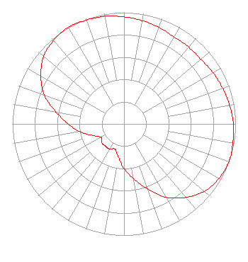 | ||||||||||||||||||
| Azimuth | Ratio | Azimuth | Ratio | Azimuth | Ratio | Azimuth | Ratio | ||||||||||||
| 0 | 0.960 | 10 | 0.940 | 20 | 0.920 | 30 | 0.900 | ||||||||||||
| 40 | 0.900 | 50 | 0.900 | 60 | 0.920 | 70 | 0.940 | ||||||||||||
| 80 | 0.960 | 90 | 0.980 | 100 | 0.990 | 110 | 1.000 | ||||||||||||
| 120 | 0.980 | 130 | 0.940 | 140 | 0.860 | 150 | 0.760 | ||||||||||||
| 160 | 0.620 | 170 | 0.500 | 180 | 0.400 | 190 | 0.300 | ||||||||||||
| 200 | 0.240 | 210 | 0.260 | 220 | 0.260 | 230 | 0.260 | ||||||||||||
| 240 | 0.240 | 250 | 0.300 | 260 | 0.400 | 270 | 0.500 | ||||||||||||
| 280 | 0.620 | 290 | 0.760 | 300 | 0.860 | 310 | 0.940 | ||||||||||||
| 320 | 0.980 | 330 | 1.000 | 340 | 0.990 | 350 | 0.980 | ||||||||||||
Structure Registration Number 1222924 Structure Type: GTOWER Registered To: American Towers LLC Structure Address: 2045 S. Gettysburg Ave. (#050893 / Dayton/ S Gettyburg) Dayton, OH County Name: Montgomery County ASR Issued: 03/29/2013 Date Built: 08/24/2001 Site Elevation: 272.8 m (895 ft.) Structure Height: 307.8 m (1010 ft.) Height Overall: 351.7 m (1154 ft.) Overall Height AMSL: 624.5 m (2049 ft.) FAA Determination: 03/14/2013 FAA Study #: 2013-AGL-2613-OE FAA Circular #: 70/7460-1K Paint & Light FAA Chapters: 4, 7, 12 PRIOR STUDY 2012-AGL-148-OE 39-43-28.6 N 84-15-17.6 W (NAD 83) 39-43-28.4 N 84-15-17.8 W (Converted to NAD 27) |
3901 Highway 121 South Bedford, TX 76021 Phone: 817-571-1229 Not-for-Profit | Title: Manager Date: 04/28/2022 Application Certifier WORD OF GOD FELLOWSHIP, INC. Word Of God Fellowship, Inc. 3901 Highway 121 South Bedford, TX 76021 Applicant RICHARD C Goetz R & L Media Systems Inc 135 N Country Club Dr Hendersonville, TN 37075 BROADCAST CONSULTANT Robert L. Olender Koerner & Olender P.c. 7020 Richard Drive Bethesda, MD 20817 LEGAL REPRESENTATIVE | |||||||||||||||||