
FCCInfo.com
A Service of Cavell, Mertz & Associates, Inc.
(855) FCC-INFO
|
|
W24CP-D from 02/23/2000 W24CP-D from 03/16/1992 |
|
|
||||||||||||||||
|
|
Status: STA – Special Temporary Authority (Licensed And Silent) Application Accepted: 05/11/2022 STA Expires: 09/06/2022 File Number: -0000190492 FCC Website Links: LMS Facility Details This Application Other W24CP-D Applications Including Superseded Applications Mailing Address Correspondence for W24CP-D Correspondence related to application -0000190492 Service Contour - Open Street Map or USGS Map (51 dBu) Service Contour - KML / Google Earth (51 dBu) Rabbit Ears Info Search for W24CP-D Site Location: 35-52-15.7 N 79-09-39.0 W (NAD 83) Site Location: 35-52-15.2 N 79-09-40.0 W (Converted to NAD 27) ERP: 14.46 kW Polarization: Horizontally polarized R/C AGL: 320 m (1050 ft.) R/C AMSL: 527.3 m (1730 ft.) Emission Mask: Full Service Site Elevation: 207.3 m. (680 ft.) Height Overall*: 334.4 m (1097 ft.) (* As Filed In This Application, may differ from ASR Data, Below.) Directional Antenna - Antenna Make/Model: Systems With Reliability Inc. 1X PANGL Antenna ID: 119159 Polarization: Horizontally polarized | ||||||||||||||||||
| Antenna Data for Antenna Id: 119159 W24CP-D LD File: -0000190492 Systems With Reliability Inc. - 1X PANGL Service: LD Standard Pattern: Y Pattern and Field Values Include a 120° Clockwise Rotation | 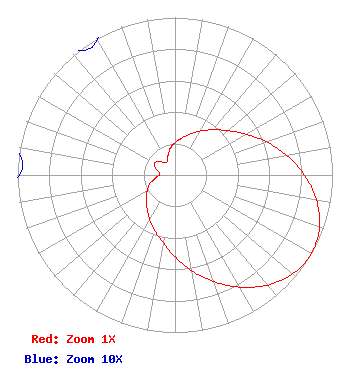 | ||||||||||||||||||
| Azimuth | Ratio | Azimuth | Ratio | Azimuth | Ratio | Azimuth | Ratio | ||||||||||||
| 0 | 0.205 | 10 | 0.237 | 20 | 0.276 | 30 | 0.323 | ||||||||||||
| 40 | 0.375 | 50 | 0.438 | 60 | 0.520 | 70 | 0.617 | ||||||||||||
| 80 | 0.721 | 90 | 0.822 | 100 | 0.912 | 110 | 0.976 | ||||||||||||
| 120 | 1.000 | 130 | 0.976 | 140 | 0.912 | 150 | 0.822 | ||||||||||||
| 160 | 0.721 | 170 | 0.617 | 180 | 0.520 | 190 | 0.438 | ||||||||||||
| 200 | 0.375 | 210 | 0.323 | 220 | 0.276 | 230 | 0.237 | ||||||||||||
| 240 | 0.205 | 250 | 0.172 | 260 | 0.130 | 270 | 0.099 | ||||||||||||
| 280 | 0.103 | 290 | 0.133 | 300 | 0.151 | 310 | 0.133 | ||||||||||||
| 320 | 0.103 | 330 | 0.099 | 340 | 0.130 | 350 | 0.172 | ||||||||||||
Structure Registration Number 1005059 Structure Type: GTOWER Registered To: American Towers LLC Structure Address: 4215 Jones Ferry Road (311110) Chapel Hill, NC County Name: Orange County ASR Issued: 03/19/2024 Date Built: 01/01/1984 Site Elevation: 207.3 m (680 ft.) Structure Height: 317 m (1040 ft.) Height Overall: 334.4 m (1097 ft.) Overall Height AMSL: 541.7 m (1777 ft.) FAA Determination: 05/30/2023 FAA Study #: 2022-ASO-18994-OE FAA Circular #: 70/7460-1L Paint & Light FAA Chapters: 4, 9, 12 PRIOR STUDY 2017-ASO-740-OE 35-52-15.7 N 79-09-39.0 W (NAD 83) 35-52-15.2 N 79-09-40.0 W (Converted to NAD 27) |
Hurst, TX 76054 Phone: 214-770-7770 Corporation | Title: Ceo Date: 05/11/2022 Application Certifier EDGE SPECTRUM, INC. Edge Spectrum, Inc. Hurst, TX 76054 Applicant Susan Hansen B. W. St. Clair 2305 Vida Shaw Rd New Iberia, LA 70563 Consultant Randy Weiss Edge Spectrum, Inc. Hurst, TX 76054 CEO Caleb Weiss Ark Multicasting, Inc. Cedar Hill, TX 75106 President | |||||||||||||||||