
FCCInfo.com
A Service of Cavell, Mertz & Associates, Inc.
(855) FCC-INFO
|
|
WOOH-LD from 05/29/2012 |
|
|
||||||||||||||||
|
|
Status: License Application Accepted: 06/21/2022 License Expires: 10/01/2029 File Number: -0000193625 FCC Website Links: LMS Facility Details This Application Other WOOH-LD Applications Including Superseded Applications Mailing Address Correspondence for WOOH-LD Correspondence related to application -0000193625 Service Contour - Open Street Map or USGS Map (51 dBu) Service Contour - KML / Google Earth (51 dBu) Rabbit Ears Info Search for WOOH-LD Site Location: 40-00-36.7 N 83-11-18.8 W (NAD 83) Site Location: 40-00-36.5 N 83-11-19.1 W (Converted to NAD 27) ERP: 15 kW Polarization: Horizontally polarized R/C AGL: 64.1 m (210 ft.) R/C AMSL: 350 m (1148 ft.) Emission Mask: Full Service Site Elevation: 285.9 m. (938 ft.) Height Overall*: 69.2 m (227 ft.) (* As Filed In This Application, may differ from ASR Data, Below.) Directional Antenna - Antenna Make/Model: Propagation System Inc PSILP12EC Antenna ID: 1009686 Polarization: Horizontally polarized | ||||||||||||||||||
| Antenna Data for Antenna Id: 1009686 WOOH-LD LD File: -0000193625 Propagation System Inc - PSILP12EC Service: LD Standard Pattern: N Pattern and Field Values Include a 95° Clockwise Rotation | 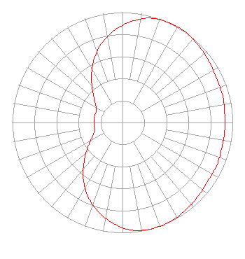 | ||||||||||||||||||
| Azimuth | Ratio | Azimuth | Ratio | Azimuth | Ratio | Azimuth | Ratio | ||||||||||||
| 5 | 0.920 | 15 | 0.980 | 25 | 1.000 | 35 | 1.000 | ||||||||||||
| 45 | 0.980 | 55 | 0.960 | 65 | 0.940 | 75 | 0.940 | ||||||||||||
| 85 | 0.930 | 95 | 0.930 | 105 | 0.930 | 115 | 0.940 | ||||||||||||
| 125 | 0.940 | 135 | 0.960 | 145 | 0.980 | 155 | 1.000 | ||||||||||||
| 165 | 1.000 | 175 | 0.980 | 185 | 0.920 | 195 | 0.840 | ||||||||||||
| 205 | 0.740 | 215 | 0.620 | 225 | 0.490 | 235 | 0.380 | ||||||||||||
| 245 | 0.300 | 255 | 0.260 | 265 | 0.260 | 275 | 0.260 | ||||||||||||
| 285 | 0.260 | 295 | 0.260 | 305 | 0.300 | 315 | 0.380 | ||||||||||||
| 325 | 0.490 | 335 | 0.620 | 345 | 0.740 | 355 | 0.840 | ||||||||||||
Structure Registration Number 1013752 Structure Type: TOWER Registered To: American Towers LLC Structure Address: 3005 Alton- Darby Rd (hilliard # 90106) Hilliard, OH County Name: Franklin County ASR Issued: 01/15/2013 Date Built: 05/29/2002 Site Elevation: 285.9 m (938 ft.) Structure Height: 68 m (223 ft.) Height Overall: 69.2 m (227 ft.) Overall Height AMSL: 355.1 m (1165 ft.) FAA Determination: 05/29/2002 FAA Study #: 02-AGL-2533-OE FAA Circular #: 70/7460-1K Paint & Light FAA Chapters: 4, 8, 12 40-00-36.7 N 83-11-18.8 W (NAD 83) 40-00-36.5 N 83-11-19.1 W (Converted to NAD 27) |
Chattanooga, TN 37401 Phone: 423-468-5100 Limited Liability Company | Title: Coo Date: 06/21/2022 Application Certifier Digital Networks-northeast, Llc Chattanooga, TN 37401 Applicant Timothy Z Sawyer T Z Sawyer Technical Consultants 2130 Hutchison Grove Court Falls Church, VA 22043 Technical Consultant Aaron P Shainis, Esq Shainis & Peltzman Chartered 1850 M Street Nw Suite 240 Washington, DC 20036 FCC Counsel | |||||||||||||||||