
FCCInfo.com
A Service of Cavell, Mertz & Associates, Inc.
(855) FCC-INFO
|
|
from 09/21/2020 from 09/09/1992 |
|
|
||||||||||||||||
|
|
Status: License Application Accepted: 06/28/2022 License Expires: 06/01/2029 File Number: -0000194105 FCC Website Links: LMS Facility Details This Application Other KVPO-LD Applications Including Superseded Applications Mailing Address Correspondence for KVPO-LD Correspondence related to application -0000194105 Service Contour - Open Street Map or USGS Map (51 dBu) Service Contour - KML / Google Earth (51 dBu) Rabbit Ears Info Search for KVPO-LD Site Location: 32-44-14.2 N 93-39-24.7 W (NAD 83) Site Location: 32-44-13.7 N 93-39-24.1 W (Converted to NAD 27) ERP: 2 kW Polarization: Horizontally polarized R/C AGL: 30 m (98 ft.) R/C AMSL: 126.3 m (414 ft.) Emission Mask: Full Service Site Elevation: 96.3 m. (316 ft.) Height Overall*: 100.6 m (330 ft.) (* As Filed In This Application, may differ from ASR Data, Below.) Directional Antenna - Antenna Make/Model: Scala PR-TV x2 Array 1@190 1@320 Antenna ID: 1008730 Polarization: Horizontally polarized | ||||||||||||||||||
| Antenna Data for Antenna Id: 1008730 KVPO-LD LD File: -0000194105 Scala - PR-TV x2 Array 1@190 1@320 Service: LD Standard Pattern: N | 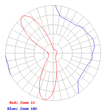 | ||||||||||||||||||
| Azimuth | Ratio | Azimuth | Ratio | Azimuth | Ratio | Azimuth | Ratio | ||||||||||||
| 0 | 0.112 | 10 | 0.081 | 20 | 0.076 | 30 | 0.075 | ||||||||||||
| 40 | 0.076 | 50 | 0.082 | 60 | 0.083 | 70 | 0.088 | ||||||||||||
| 80 | 0.088 | 90 | 0.083 | 100 | 0.082 | 110 | 0.076 | ||||||||||||
| 120 | 0.075 | 130 | 0.076 | 140 | 0.081 | 150 | 0.112 | ||||||||||||
| 160 | 0.186 | 170 | 0.442 | 180 | 0.813 | 185 | 0.944 | ||||||||||||
| 190 | 1.000 | 195 | 0.948 | 200 | 0.820 | 210 | 0.458 | ||||||||||||
| 220 | 0.202 | 230 | 0.132 | 240 | 0.104 | 250 | 0.098 | ||||||||||||
| 260 | 0.098 | 270 | 0.104 | 280 | 0.132 | 290 | 0.202 | ||||||||||||
| 300 | 0.458 | 310 | 0.820 | 315 | 0.948 | 320 | 1.000 | ||||||||||||
| 325 | 0.944 | 330 | 0.813 | 340 | 0.442 | 350 | 0.186 | ||||||||||||
Structure Registration Number 1057682 Structure Type: GTOWER Registered To: Alltel Corporation Structure Address: Midway Cell Site Benton, LA County Name: Bossier Parish ASR Issued: 05/25/2021 Date Built: 01/15/1999 Site Elevation: 96.3 m (316 ft.) Structure Height: 97.5 m (320 ft.) Height Overall: 100.6 m (330 ft.) Overall Height AMSL: 196.9 m (646 ft.) FAA Determination: 05/12/2021 FAA Study #: 2021-ASW-6271-OE FAA Circular #: 70/7460-1J Paint & Light FAA Chapters: 4, 8, 13 OM&L to remain the same as prior study = A MED-DUAL SYSTEM 32-44-14.2 N 93-39-24.7 W (NAD 83) 32-44-13.7 N 93-39-24.1 W (Converted to NAD 27) |
Po Box 11409 Chattanooga, TN 37401 Phone: 423-468-5100 Limited Liability Company | Title: Chief Engineer Date: 06/28/2022 Application Certifier Digital Networks-southwest, Llc Chattanooga, TN 37401 Applicant Aaron P Shainis Shainis & Peltzman, Chartered 1850 M St. Nw Suite 240 Washington, DC 20036 FCC Legal Counsel | |||||||||||||||||