
FCCInfo.com
A Service of Cavell, Mertz & Associates, Inc.
(855) FCC-INFO
|
|
KFJX from 09/20/1996 |
Virtual Channel 14 |
|
||||||||||||||||
|
|
Repacking Information: No changes Status: License Application Accepted: 07/11/2022 License Expires: 06/01/2022 File Number: -0000194731 FCC Website Links: LMS Facility Details This Application Other KFJX Applications Including Superseded Applications Mailing Address Correspondence for KFJX Correspondence related to application -0000194731 Service Contour - Open Street Map or USGS Map (36 dBu) Service Contour - KML / Google Earth (36 dBu) Public Inspection Files Rabbit Ears Info Search for KFJX Site Location: 37-13-15.0 N 94-42-26.0 W (NAD 83) Site Location: 37-13-14.8 N 94-42-25.2 W (Converted to NAD 27) ERP: 45.1 kW Polarization: Elliptically polarized HAAT: 337 m (1106 ft.) Electrical Beam Tilt: 0.5 degrees R/C AGL: 336.5 m (1104 ft.) R/C AMSL: 607.7 m (1994 ft.) Site Elevation: 271.2 m. (890 ft.) Height Overall*: 344.1 m (1129 ft.) (* As Filed In This Application, may differ from ASR Data, Below.) Directional Antenna - Antenna Make/Model: DIELECTRIC THV-8A13-R C145 Antenna ID: 1005210 Polarization: Elliptically polarized | ||||||||||||||||||
| Antenna Data for Antenna Id: 1005210 KFJX DT File: -0000194731 DIELECTRIC - THV-8A13-R C145 Service: DT Standard Pattern: Y Pattern and Field Values Include a 180° Clockwise Rotation | 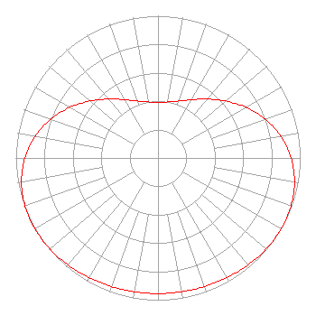 | ||||||||||||||||||
| Azimuth | Ratio | Azimuth | Ratio | Azimuth | Ratio | Azimuth | Ratio | ||||||||||||
| 0 | 0.392 | 10 | 0.400 | 20 | 0.426 | 30 | 0.473 | ||||||||||||
| 40 | 0.541 | 50 | 0.623 | 60 | 0.713 | 70 | 0.801 | ||||||||||||
| 80 | 0.877 | 90 | 0.936 | 100 | 0.975 | 110 | 0.995 | ||||||||||||
| 120 | 1.000 | 130 | 0.994 | 140 | 0.983 | 150 | 0.971 | ||||||||||||
| 160 | 0.962 | 170 | 0.956 | 180 | 0.954 | 190 | 0.956 | ||||||||||||
| 200 | 0.962 | 210 | 0.971 | 220 | 0.983 | 230 | 0.994 | ||||||||||||
| 240 | 1.000 | 250 | 0.995 | 260 | 0.975 | 270 | 0.936 | ||||||||||||
| 280 | 0.877 | 290 | 0.801 | 300 | 0.713 | 310 | 0.623 | ||||||||||||
| 320 | 0.541 | 330 | 0.473 | 340 | 0.426 | 350 | 0.400 | ||||||||||||
Structure Registration Number 1032005 Structure Type: GTOWER Registered To: QueenB Television of Kansas/Missouri, LLC Structure Address: Int Hwy 69 & Lawton Rd 4 Mi W Of Lawton Ks Pittsburg, KS County Name: Cherokee County ASR Issued: 06/22/2022 Date Built: 06/30/2022 Site Elevation: 271.2 m (890 ft.) Structure Height: 310.3 m (1018 ft.) Height Overall: 344.1 m (1129 ft.) Overall Height AMSL: 615.3 m (2019 ft.) FAA Determination: 06/17/2022 FAA Study #: 2022-ACE-2964-OE FAA Circular #: 70/7460-1M Paint & Light FAA Chapters: 4, 9, 15 PRIOR STUDY 2017-ACE-6793-OE 37-13-15.0 N 94-42-26.0 W (NAD 83) 37-13-14.8 N 94-42-25.2 W (Converted to NAD 27) |
525 Blackburn Drive Augusta, GA 30907 Phone: 706-922-5644 Limited Liability Company | Title: President Date: 07/11/2022 Application Certifier Sagamorehill Of Missouri Licenses, Llc 525 Blackburn Drive Augusta, GA 30907 Applicant Wayne D. Johnsen, Esq Wiley Rein Llp 2050 M Street, N.w. Washington, DC 20036 Erik C Swanson, PE Hatfield & Dawson 9500 Greenwood Ave N Seattle, WA 98103 Consulting Engineer | |||||||||||||||||