
FCCInfo.com
A Service of Cavell, Mertz & Associates, Inc.
(855) FCC-INFO
|
|
WDMI-LD from 06/29/2004 WDMI-LD from 06/13/1990 WDMI-LD from 05/24/1990 WDMI-LD from 06/15/1984 |
|
|
||||||||||||||||
|
|
Status: License Application Accepted: 07/05/2022 License Expires: 04/01/2030 File Number: -0000194480 FCC Website Links: LMS Facility Details This Application Other WDMI-LD Applications Including Superseded Applications Mailing Address Correspondence for WDMI-LD Correspondence related to application -0000194480 Service Contour - Open Street Map or USGS Map (51 dBu) Service Contour - KML / Google Earth (51 dBu) Rabbit Ears Info Search for WDMI-LD Site Location: 45-04-07.1 N 93-10-35.1 W (NAD 83) Site Location: 45-04-07.2 N 93-10-34.3 W (Converted to NAD 27) ERP: 15 kW Polarization: Circularly polarized Electrical Beam Tilt: 0.5 degrees R/C AGL: 160 m (525 ft.) R/C AMSL: 441 m (1447 ft.) Emission Mask: Full Service Site Elevation: 281 m. (922 ft.) Height Overall*: 190.5 m (625 ft.) (* As Filed In This Application, may differ from ASR Data, Below.) Directional Antenna - Antenna Make/Model: Systems With Reliability Inc. SWEDL12WCRR/26-CP Antenna ID: 1009742 Polarization: Circularly polarized | ||||||||||||||||||
| Antenna Data for Antenna Id: 1009742 WDMI-LD LD File: -0000194480 Systems With Reliability Inc. - SWEDL12WCRR/26-CP Service: LD Standard Pattern: N Pattern and Field Values Include a 265° Clockwise Rotation | 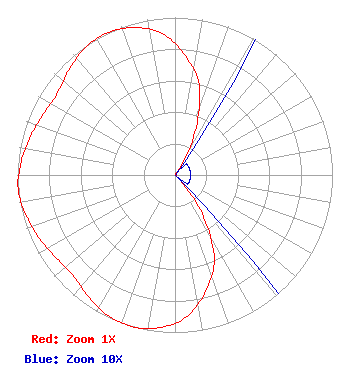 | ||||||||||||||||||
| Azimuth | Ratio | Azimuth | Ratio | Azimuth | Ratio | Azimuth | Ratio | ||||||||||||
| 5 | 0.760 | 15 | 0.590 | 25 | 0.300 | 35 | 0.010 | ||||||||||||
| 45 | 0.010 | 55 | 0.010 | 65 | 0.010 | 75 | 0.010 | ||||||||||||
| 85 | 0.010 | 95 | 0.010 | 105 | 0.010 | 115 | 0.010 | ||||||||||||
| 125 | 0.010 | 135 | 0.010 | 145 | 0.300 | 155 | 0.590 | ||||||||||||
| 165 | 0.760 | 175 | 0.900 | 185 | 0.970 | 195 | 1.000 | ||||||||||||
| 205 | 0.990 | 215 | 0.950 | 225 | 0.910 | 235 | 0.920 | ||||||||||||
| 245 | 0.950 | 255 | 0.980 | 265 | 1.000 | 275 | 0.980 | ||||||||||||
| 285 | 0.950 | 295 | 0.920 | 305 | 0.910 | 315 | 0.950 | ||||||||||||
| 325 | 0.990 | 335 | 1.000 | 345 | 0.970 | 355 | 0.900 | ||||||||||||
Structure Registration Number 1060523 Structure Type: TOWER Registered To: ARDEN TOWERS INC Structure Address: 1777 14th St Arden Hills, MN County Name: Ramsey County ASR Issued: 04/19/2011 Date Built: 04/20/2011 Site Elevation: 281 m (922 ft.) Structure Height: 190.5 m (625 ft.) Height Overall: 190.5 m (625 ft.) Overall Height AMSL: 471.5 m (1547 ft.) FAA Determination: 03/10/2011 FAA Study #: 2011-AGL-1809-OE Paint & Light FAA Chapters: A2, H, 1, 3, 4, 13, 21, 23 Continue As Is OM&L = A MED-DUAL SYSTEM 45-04-07.1 N 93-10-35.1 W (NAD 83) 45-04-07.2 N 93-10-34.3 W (Converted to NAD 27) |
3901 Highway 121 South Bedford, TX 76021 Phone: 817-571-1229 Not-for-Profit | Title: Manager Date: 07/05/2022 Application Certifier WORD OF GOD FELLOWSHIP, INC. Word Of God Fellowship, Inc. 3901 Highway 121 South Bedford, TX 76021 Applicant RICHARD C. Goetz Rl Media Systems 135 N Country Club Dr Hendersonville, TN 37075 BROADCAST CONSULTANT Robert L. Olender, ESQ Koerner & Olender P.c. 7020 Richard Drive Bethesda, MD 20817 LEGAL REPRESENTATIVE | |||||||||||||||||