
FCCInfo.com
A Service of Cavell, Mertz & Associates, Inc.
(855) FCC-INFO
|
|
WTKJ-LD from 01/01/2006 WTKJ-LD from 10/19/2004 |
|
|
||||||||||||||||
|
|
Status: License (Licensed And Silent) Application Accepted: 07/11/2022 License Expires: 06/01/2023 File Number: -0000194804 FCC Website Links: LMS Facility Details This Application Other WTKJ-LD Applications Including Superseded Applications Mailing Address Correspondence for WTKJ-LD Correspondence related to application -0000194804 Service Contour - Open Street Map or USGS Map (51 dBu) Service Contour - KML / Google Earth (51 dBu) Rabbit Ears Info Search for WTKJ-LD Site Location: 43-58-04.6 N 75-48-21.2 W (NAD 83) Site Location: 43-58-04.4 N 75-48-22.5 W (Converted to NAD 27) ERP: 1.5 kW Polarization: Horizontally polarized Electrical Beam Tilt: 1.75 degrees R/C AGL: 51 m (167 ft.) R/C AMSL: 358.8 m (1177 ft.) Emission Mask: Stringent Site Elevation: 307.8 m. (1010 ft.) Height Overall*: 59.4 m (195 ft.) (* As Filed In This Application, may differ from ASR Data, Below.) Directional Antenna - Antenna Make/Model: Electronics Research Inc. AL8-2 Antenna ID: 1009766 Polarization: Horizontally polarized | ||||||||||||||||||
| Antenna Data for Antenna Id: 1009766 WTKJ-LD LD File: -0000194804 Electronics Research Inc. - AL8-2 Service: LD Standard Pattern: N | 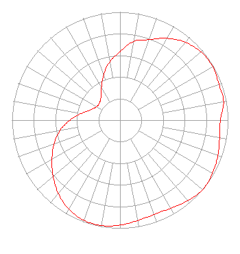 | ||||||||||||||||||
| Azimuth | Ratio | Azimuth | Ratio | Azimuth | Ratio | Azimuth | Ratio | ||||||||||||
| 0 | 0.633 | 10 | 0.740 | 20 | 0.793 | 30 | 0.874 | ||||||||||||
| 40 | 0.940 | 50 | 0.980 | 60 | 0.991 | 70 | 0.975 | ||||||||||||
| 80 | 0.974 | 90 | 0.929 | 100 | 0.937 | 110 | 0.964 | ||||||||||||
| 120 | 0.989 | 130 | 1.000 | 140 | 0.973 | 150 | 0.940 | ||||||||||||
| 160 | 0.928 | 170 | 0.943 | 180 | 0.971 | 190 | 0.990 | ||||||||||||
| 200 | 0.985 | 210 | 0.950 | 220 | 0.888 | 230 | 0.809 | ||||||||||||
| 240 | 0.727 | 250 | 0.650 | 260 | 0.565 | 270 | 0.463 | ||||||||||||
| 280 | 0.360 | 290 | 0.285 | 300 | 0.250 | 310 | 0.247 | ||||||||||||
| 320 | 0.275 | 330 | 0.343 | 340 | 0.443 | 350 | 0.546 | ||||||||||||
Structure Registration Number 1207013 Structure Type: TOWER Registered To: K2 Towers II, LLC Structure Address: Miser Road Watertown, NY County Name: Jefferson County ASR Issued: 05/13/2022 Date Built: 01/01/1998 Site Elevation: 307.8 m (1010 ft.) Structure Height: 59.4 m (195 ft.) Height Overall: 59.4 m (195 ft.) Overall Height AMSL: 367.2 m (1205 ft.) FAA Determination: 11/16/1999 FAA Study #: 99-AEA-2926-OE Paint & Light FAA Chapters: NONE PRIOR FAA # 96-AEA-1759-OE 43-58-04.6 N 75-48-21.2 W (NAD 83) 43-58-04.4 N 75-48-22.5 W (Converted to NAD 27) |
888c 8th Ave Suite 733 New York, NY 10019 Phone: 212-580-1349 Limited Liability Company | Title: Ceo Date: 07/11/2022 Application Certifier EDGE SPECTRUM, INC. Edge Spectrum, Inc. Hurst, TX 76054 Applicant Susan Hansen B. W. St. Clair 2305 Vida Shaw Rd. New Iberia, LA 70563 Consultant Ari Meltzer Wiley Rein Llp 2050 M Street Nw Washington, DC 20036 Randy Weiss Edge Spectrum, Inc. Hurst, TX 76054 CEO Caleb Weiss Ark Multicasting, Inc. Cedar Hill, TX 75106 President Josh Weiss Ark Multicasting, Inc. Cedar Hill, TX 75106 CEO | |||||||||||||||||