
FCCInfo.com
A Service of Cavell, Mertz & Associates, Inc.
(855) FCC-INFO
|
|
|
|
|
||||||||||||||||
|
|
Status: License (Licensed And Silent) Application Accepted: 07/14/2022 License Expires: 10/01/2030 File Number: -0000194988 FCC Website Links: LMS Facility Details This Application Other K29KY-D Applications Including Superseded Applications Mailing Address Correspondence for K29KY-D Correspondence related to application -0000194988 Service Contour - Open Street Map or USGS Map (51 dBu) Service Contour - KML / Google Earth (51 dBu) Rabbit Ears Info Search for K29KY-D Site Location: 43-11-29.2 N 112-20-40.9 W (NAD 83) Site Location: 43-11-29.5 N 112-20-38.0 W (Converted to NAD 27) ERP: 0.042 kW Polarization: Horizontally polarized R/C AGL: 5.5 m (18 ft.) R/C AMSL: 1374 m (4508 ft.) Emission Mask: Stringent Site Elevation: 1368.5 m. (4490 ft.) Height Overall*: 62.8 m (206 ft.) (* As Filed In This Application, may differ from ASR Data, Below.) Directional Antenna - Antenna Make/Model: Samco SAM-560 Antenna ID: 1009756 Polarization: Horizontally polarized | ||||||||||||||||||
| Antenna Data for Antenna Id: 1009756 K29KY-D LD File: -0000194988 Samco - SAM-560 Service: LD Standard Pattern: Y Pattern and Field Values Include a 200.0° Clockwise Rotation | 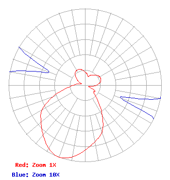 | ||||||||||||||||||
| Azimuth | Ratio | Azimuth | Ratio | Azimuth | Ratio | Azimuth | Ratio | ||||||||||||
| 0 | 0.170 | 10 | 0.150 | 20 | 0.120 | 30 | 0.150 | ||||||||||||
| 40 | 0.170 | 50 | 0.200 | 60 | 0.220 | 70 | 0.220 | ||||||||||||
| 80 | 0.200 | 90 | 0.150 | 100 | 0.100 | 110 | 0.050 | ||||||||||||
| 120 | 0.150 | 130 | 0.150 | 140 | 0.250 | 150 | 0.450 | ||||||||||||
| 160 | 0.650 | 170 | 0.750 | 180 | 0.850 | 190 | 0.950 | ||||||||||||
| 200 | 1.000 | 210 | 0.950 | 220 | 0.850 | 230 | 0.750 | ||||||||||||
| 240 | 0.650 | 250 | 0.450 | 260 | 0.250 | 270 | 0.150 | ||||||||||||
| 280 | 0.100 | 290 | 0.050 | 300 | 0.100 | 310 | 0.150 | ||||||||||||
| 320 | 0.200 | 330 | 0.220 | 340 | 0.220 | 350 | 0.200 | ||||||||||||
Structure Registration Number 1040445 Structure Type: TOWER Registered To: American Towers LLC Structure Address: 290 N. Ash Street (blackfoot #89402) Blackfoot, ID County Name: Bingham County ASR Issued: 01/15/2013 Date Built: 02/01/1958 Site Elevation: 1368.5 m (4490 ft.) Structure Height: 61.6 m (202 ft.) Height Overall: 62.8 m (206 ft.) Overall Height AMSL: 1431.3 m (4696 ft.) FAA Determination: 12/01/2005 FAA Study #: 2005-ANM-2367-OE FAA Circular #: 70/7460-1H Paint & Light FAA Chapters: 4, 6, 13 OM&L to remain the same as prior study = 24-HR MED-STROBES 43-11-29.2 N 112-20-40.9 W (NAD 83) 43-11-29.5 N 112-20-38.0 W (Converted to NAD 27) |
P.o. Box 15009 Fresno, CA 93702 Phone: 866-436-6388 Limited Liability Company | Title: Officer Date: 07/14/2022 Application Certifier Sawtooth Mountains Broadcast & Wireless Corp. 943 W. Overland Road Meridian, ID 83642 Applicant BROOKS HARLOW, HARLOW Sawtooth Mountains Broadcast & Wireless Corp. 12703 Fox Woods Dr Herndon, VA 20171 Benjamin Pidek, P.E Ben Pidek Consulting, Llc 7670 Coventry Dr. Temperance, MI 48182 Consulting Engineer | |||||||||||||||||