
FCCInfo.com
A Service of Cavell, Mertz & Associates, Inc.
(855) FCC-INFO
|
|
|
Virtual Channel 5 |
|
||||||||||||||||||||||
|
|
Repacking Information: No changes Status: License Application Accepted: 08/15/2022 License Expires: 10/01/2028 File Number: -0000197623 FCC Website Links: LMS Facility Details This Application Other WDTV Applications Including Superseded Applications Mailing Address Correspondence for WDTV Correspondence related to application -0000197623 Service Contour - Open Street Map or USGS Map (41 dBu) Service Contour - KML / Google Earth (41 dBu) Public Inspection Files History Cards for WDTV Rabbit Ears Info Search for WDTV Site Location: 39-18-02.0 N 80-20-36.0 W (NAD 83) Site Location: 39-18-01.7 N 80-20-36.7 W (Converted to NAD 27) ERP: 935 kW Polarization: Elliptically polarized HAAT: 228.1 m (748 ft.) Electrical Beam Tilt: 0.5 degrees R/C AGL: 172.9 m (567 ft.) R/C AMSL: 587.4 m (1927 ft.) Site Elevation: 414.5 m. (1360 ft.) Height Overall*: 192.7 m (632 ft.) (* As Filed In This Application, may differ from ASR Data, Below.) Directional Antenna - Antenna Make/Model: Dielectric TFU-29EST/VP-R 4C140 Antenna ID: 1009925 Polarization: Elliptically polarized
| ||||||||||||||||||||||||
| Antenna Data for Antenna Id: 1009925 WDTV DT File: -0000197623 Dielectric - TFU-29EST/VP-R 4C140 Service: DT Standard Pattern: N Pattern and Field Values Include a 155° Clockwise Rotation | 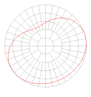 | ||||||||||||||||||||||||
| Azimuth | Ratio | Azimuth | Ratio | Azimuth | Ratio | Azimuth | Ratio | ||||||||||||||||||
| 5 | 0.594 | 15 | 0.664 | 25 | 0.742 | 35 | 0.820 | ||||||||||||||||||
| 45 | 0.890 | 55 | 0.945 | 65 | 0.982 | 75 | 1.000 | ||||||||||||||||||
| 80 | 1.000 | 85 | 1.000 | 95 | 0.987 | 105 | 0.966 | ||||||||||||||||||
| 115 | 0.943 | 125 | 0.922 | 135 | 0.907 | 145 | 0.898 | ||||||||||||||||||
| 155 | 0.895 | 165 | 0.898 | 175 | 0.907 | 185 | 0.922 | ||||||||||||||||||
| 195 | 0.943 | 205 | 0.966 | 215 | 0.987 | 225 | 1.000 | ||||||||||||||||||
| 230 | 1.000 | 235 | 1.000 | 245 | 0.982 | 255 | 0.945 | ||||||||||||||||||
| 265 | 0.890 | 275 | 0.820 | 285 | 0.742 | 295 | 0.664 | ||||||||||||||||||
| 305 | 0.594 | 315 | 0.538 | 325 | 0.503 | 335 | 0.490 | ||||||||||||||||||
| 345 | 0.503 | 355 | 0.538 | ||||||||||||||||||||||
Structure Registration Number 1034466 Structure Type: TOWER Registered To: Gray Media Group, Inc. Structure Address: North 16 Extended Clarksburg, WV County Name: Harrison County ASR Issued: 09/09/2020 Date Built: 10/26/1992 Site Elevation: 414.5 m (1360 ft.) Structure Height: 182.9 m (600 ft.) Height Overall: 192.7 m (632 ft.) Overall Height AMSL: 607.2 m (1992 ft.) FAA Determination: 10/05/1979 FAA Study #: 79-AEA-704-OE Paint & Light FAA Chapters: 1, 3, 5, 14, 21 RED LIGHTS/PAINT 39-18-02.0 N 80-20-36.0 W (NAD 83) 39-18-01.7 N 80-20-36.7 W (Converted to NAD 27) |
4370 Peachtree Rd Ne Atlanta, GA 30319 Phone: 404-504-9828 Limited Liability Company | Title: Assistant Secretary Date: 08/15/2022 Application Certifier GRAY TELEVISION LICENSEE, LLC Gray Television Licensee, Llc 4370 Peachtree Rd Ne Atlanta, GA 30319 Applicant DAVID BURKE Gray Television Licensee, Llc 201 Monroe St. Montgomery, AL 36104 SENIOR VICE PRESIDENT AND CTO Joseph M. Davis, P.E. Chesapeake Rf Consultants, Llc 207 Old Dominion Road Yorktown, VA 23692 Consulting Engineer Joan Stewart Wiley Rein Llp 2050 M Street, Nw Washington, DC 20036 | |||||||||||||||||||||||
| |||||||||||||||||||||||||