
FCCInfo.com
A Service of Cavell, Mertz & Associates, Inc.
(855) FCC-INFO
|
|
|
Virtual Channel 8 |  |
|
|||||||||||||||||||||
|
|
Repacking Information: No changes Status: License Application Accepted: 10/11/2022 License Expires: 06/01/2030 File Number: -0000202189 FCC Website Links: LMS Facility Details This Application Other KPTS Applications Including Superseded Applications Mailing Address Correspondence for KPTS Correspondence related to application -0000202189 Service Contour - Open Street Map or USGS Map (36 dBu) Service Contour - KML / Google Earth (36 dBu) Public Inspection Files History Cards for KPTS Rabbit Ears Info Search for KPTS Site Location: 38-03-21.4 N 97-46-36.1 W (NAD 83) Site Location: 38-03-21.4 N 97-46-34.9 W (Converted to NAD 27) ERP: 32 kW Polarization: Horizontally polarized HAAT: 244 m (801 ft.) R/C AGL: 226.1 m (742 ft.) R/C AMSL: 704.6 m (2312 ft.) Site Elevation: 478.5 m. (1570 ft.) Height Overall*: 238.3 m (782 ft.) (* As Filed In This Application, may differ from ASR Data, Below.) Directional Antenna - Antenna Make/Model: RCA Corp. TF-12AH Antenna ID: 87205 Polarization: Horizontally polarized | ||||||||||||||||||||||||
| Antenna Data for Antenna Id: 87205 KPTS DT File: -0000202189 RCA Corp. - TF-12AH Service: DT Standard Pattern: Y | 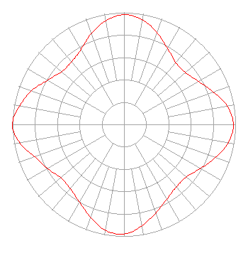 | ||||||||||||||||||||||||
| Azimuth | Ratio | Azimuth | Ratio | Azimuth | Ratio | Azimuth | Ratio | ||||||||||||||||||
| 0 | 0.980 | 10 | 0.950 | 20 | 0.870 | 30 | 0.780 | ||||||||||||||||||
| 40 | 0.720 | 50 | 0.720 | 60 | 0.770 | 70 | 0.850 | ||||||||||||||||||
| 80 | 0.940 | 90 | 0.980 | 100 | 0.950 | 110 | 0.870 | ||||||||||||||||||
| 120 | 0.790 | 130 | 0.730 | 140 | 0.730 | 150 | 0.770 | ||||||||||||||||||
| 160 | 0.840 | 170 | 0.920 | 180 | 0.980 | 190 | 0.960 | ||||||||||||||||||
| 200 | 0.880 | 210 | 0.800 | 220 | 0.750 | 230 | 0.740 | ||||||||||||||||||
| 240 | 0.790 | 250 | 0.850 | 260 | 0.950 | 270 | 1.000 | ||||||||||||||||||
| 280 | 0.950 | 290 | 0.880 | 300 | 0.790 | 310 | 0.730 | ||||||||||||||||||
| 320 | 0.730 | 330 | 0.770 | 340 | 0.860 | 350 | 0.940 | ||||||||||||||||||
Structure Registration Number 1037798 Structure Type: GTOWER Registered To: Kansas Public Telecommunications Service, Inc. Structure Address: East 4th Street And Buhler Road; 8.2 Miles East Of Hutchinson, KS County Name: Reno County ASR Issued: 04/21/2015 Date Built: 05/01/1953 Site Elevation: 478.5 m (1570 ft.) Structure Height: 214.1 m (702 ft.) Height Overall: 238.3 m (782 ft.) Overall Height AMSL: 716.8 m (2352 ft.) FAA Determination: 12/17/1997 FAA Study #: 97-ACE-1571-OE FAA Circular #: 70/7460-1J Paint & Light FAA Chapters: 3, 4, 5, 13 38-03-21.4 N 97-46-36.1 W (NAD 83) 38-03-21.4 N 97-46-34.9 W (Converted to NAD 27) |
320 W. 21st Street N. Wichita, KS 67203 Phone: 316-838-3090 Not-for-Profit | Title: President And Ceo Date: 10/11/2022 Application Certifier Kansas Public Telecommunications Service, Inc. 320 W. 21st Street N. Wichita, KS 67203 Applicant Derek Teslik Gray Miller Persh Llp 2233 Wisconsin Avenue Nw Ste. 226 Washington, DC 20007 | |||||||||||||||||||||||
|
| ||||||||||||||||||||||||
