
FCCInfo.com
A Service of Cavell, Mertz & Associates, Inc.
(855) FCC-INFO
|
|
K43JV from 09/24/1992 |
|
|
||||||||||||||||
|
|
Status: Construction Permit (Licensed And Silent) Application Accepted: 08/12/2022 K43JV CP Expires: 08/01/2024 File Number: -0000197498 FCC Website Links: LMS Facility Details This Application Other K43JV Applications Including Superseded Applications Mailing Address Correspondence for K43JV Correspondence related to application -0000197498 Service Contour - Open Street Map or USGS Map (51 dBu) Service Contour - KML / Google Earth (51 dBu) Rabbit Ears Info Search for K43JV Site Location: 40-16-23.8 N 111-55-29.6 W (NAD 83) Site Location: 40-16-24.0 N 111-55-26.8 W (Converted to NAD 27) ERP: 1.5 kW Polarization: Elliptically polarized R/C AGL: 15 m (49 ft.) R/C AMSL: 2314 m (7592 ft.) Emission Mask: Full Service Site Elevation: 2299 m. (7543 ft.) Height Overall*: 21.9 m (72 ft.) (* As Filed In This Application, may differ from ASR Data, Below.) Directional Antenna - Antenna Make/Model: DIELECTRIC DLP-8B/VP Antenna ID: 1004884 Polarization: Elliptically polarized | ||||||||||||||||||
| Antenna Data for Antenna Id: 1004884 K43JV LD File: -0000197498 DIELECTRIC - DLP-8B/VP Service: LD Standard Pattern: Y Pattern and Field Values Include a 100° Clockwise Rotation | 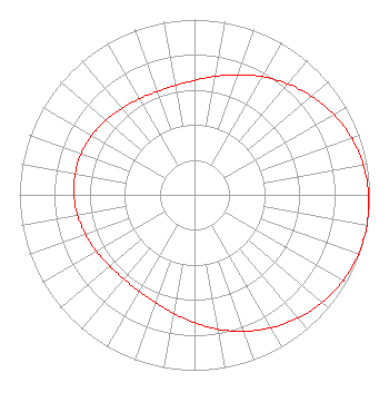 | ||||||||||||||||||
| Azimuth | Ratio | Azimuth | Ratio | Azimuth | Ratio | Azimuth | Ratio | ||||||||||||
| 0 | 0.653 | 10 | 0.686 | 20 | 0.729 | 30 | 0.778 | ||||||||||||
| 40 | 0.828 | 50 | 0.875 | 60 | 0.918 | 70 | 0.953 | ||||||||||||
| 80 | 0.979 | 90 | 0.995 | 100 | 1.000 | 110 | 0.995 | ||||||||||||
| 120 | 0.979 | 130 | 0.953 | 140 | 0.918 | 150 | 0.875 | ||||||||||||
| 160 | 0.828 | 170 | 0.778 | 180 | 0.729 | 190 | 0.686 | ||||||||||||
| 200 | 0.653 | 210 | 0.633 | 220 | 0.627 | 230 | 0.632 | ||||||||||||
| 240 | 0.646 | 250 | 0.662 | 260 | 0.678 | 270 | 0.689 | ||||||||||||
| 280 | 0.692 | 290 | 0.689 | 300 | 0.678 | 310 | 0.662 | ||||||||||||
| 320 | 0.646 | 330 | 0.632 | 340 | 0.627 | 350 | 0.633 | ||||||||||||
Structure Registration Number 1206227 Structure Type: TOWER Registered To: Line One Inc Structure Address: Lake Mountain Provo, UT County Name: Utah County ASR Issued: 11/17/1999 Date Built: 05/01/2000 Site Elevation: 2299 m (7543 ft.) Structure Height: 19 m (62 ft.) Height Overall: 21.9 m (72 ft.) Overall Height AMSL: 2320.9 m (7615 ft.) FAA Determination: 04/10/1998 FAA Study #: 97-ANM-1553-OE Paint & Light FAA Chapters: NONE 40-16-23.8 N 111-55-29.6 W (NAD 83) 40-16-24.0 N 111-55-26.8 W (Converted to NAD 27) |
Hurst, TX 76054 Phone: 214-770-7770 Corporation | Title: Ceo Date: 08/12/2022 Application Certifier EDGE SPECTRUM, INC. Edge Spectrum, Inc. Hurst, TX 76054 Applicant Josh Weiss Ark Multicasting, Inc. Cedar Hill, TX 75106 CEO Susan Hansen B. W. St. Clair 2305 Vida Shaw Rd. New Iberia, LA 70563 Consultant Ari Meltzer Wiley Rein Llp 2050 M Street, Nw Washington, DC 20036 Caleb Weiss Ark Multicasting, Inc. Cedar Hill, TX 75106 President Randy Weiss Edge Spectrum, Inc. Hurst, TX 76054 CEO | |||||||||||||||||