
FCCInfo.com
A Service of Cavell, Mertz & Associates, Inc.
(855) FCC-INFO
|
|
|
|
|
||||||||||||||||
|
|
Status: License Application Accepted: 08/19/2022 License Expires: 12/03/2029 File Number: -0000197912 FCC Website Links: LMS Facility Details This Application Other WZEO-LD Applications Including Superseded Applications Mailing Address Correspondence for WZEO-LD Correspondence related to application -0000197912 Service Contour - Open Street Map or USGS Map (51 dBu) Service Contour - KML / Google Earth (51 dBu) Rabbit Ears Info Search for WZEO-LD Site Location: 43-44-52.3 N 91-17-54.6 W (NAD 83) Site Location: 43-44-52.4 N 91-17-54.1 W (Converted to NAD 27) ERP: 15 kW Polarization: Circularly polarized R/C AGL: 115 m (377 ft.) R/C AMSL: 473.4 m (1553 ft.) Emission Mask: Full Service Site Elevation: 358.4 m. (1176 ft.) Height Overall*: 153.9 m (505 ft.) (* As Filed In This Application, may differ from ASR Data, Below.) Directional Antenna - Antenna Make/Model: JAMPRO JA-SS-12/26 SCO Antenna ID: 1009952 Polarization: Circularly polarized | ||||||||||||||||||
| Antenna Data for Antenna Id: 1009952 WZEO-LD LD File: -0000197912 JAMPRO - JA-SS-12/26 SCO Service: LD Standard Pattern: N Pattern and Field Values Include a 17° Clockwise Rotation | 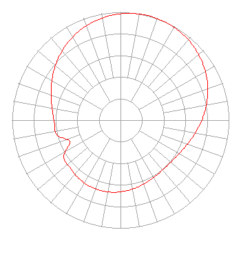 | ||||||||||||||||||
| Azimuth | Ratio | Azimuth | Ratio | Azimuth | Ratio | Azimuth | Ratio | ||||||||||||
| 7 | 0.994 | 17 | 1.000 | 27 | 0.994 | 37 | 0.978 | ||||||||||||
| 47 | 0.951 | 57 | 0.915 | 67 | 0.871 | 77 | 0.820 | ||||||||||||
| 87 | 0.767 | 97 | 0.715 | 107 | 0.668 | 117 | 0.631 | ||||||||||||
| 127 | 0.609 | 137 | 0.602 | 147 | 0.608 | 157 | 0.623 | ||||||||||||
| 167 | 0.642 | 177 | 0.659 | 187 | 0.672 | 197 | 0.676 | ||||||||||||
| 207 | 0.672 | 217 | 0.659 | 227 | 0.642 | 237 | 0.623 | ||||||||||||
| 247 | 0.508 | 257 | 0.602 | 267 | 0.609 | 277 | 0.631 | ||||||||||||
| 287 | 0.668 | 297 | 0.715 | 307 | 0.767 | 317 | 0.820 | ||||||||||||
| 327 | 0.871 | 337 | 0.915 | 347 | 0.951 | 357 | 0.978 | ||||||||||||
Structure Registration Number 1026950 Structure Type: GTOWER Registered To: American Towers LLC Structure Address: 1.3 Miles West Of Sr 26 7 Km S (372424 / Talon) Hokah, MN County Name: Houston County ASR Issued: 04/21/2021 Date Built: 07/27/1998 Site Elevation: 358.4 m (1176 ft.) Structure Height: 152.1 m (499 ft.) Height Overall: 153.9 m (505 ft.) Overall Height AMSL: 512.3 m (1681 ft.) FAA Determination: 04/19/2021 FAA Study #: 2021-AGL-2500-OE FAA Circular #: 70/7460-1L Paint & Light FAA Chapters: 4, 8, 12 PRIOR STUDIES 2009-AGL-580-OE / 2015-AGL-16241-OE 43-44-52.3 N 91-17-54.6 W (NAD 83) 43-44-52.4 N 91-17-54.1 W (Converted to NAD 27) |
1187 N Willow Ave Suite 103 #143 Clovis, CA 93611 Phone: 559-412-2825 Limited Liability Company | Title: Managing Member/coo Date: 08/19/2022 Application Certifier My Central Valley, Llc 1187 N Willow Ave Suite 103 #143 Clovis, CA 93611 Applicant Thomas Driggers My Central Valley, Llc 1187 N Willow Ave Suite 103 #143 Clovis, CA 93611 CTO/Engineer Scott Woodworth Edinger Associates Pllc 1725 I Street, Nw Suite 300 Washington, DC 20006 | |||||||||||||||||