
FCCInfo.com
A Service of Cavell, Mertz & Associates, Inc.
(855) FCC-INFO
|
|
W35DX-D from 06/25/2019 K49EP-D from 10/23/2015 |
|
|
||||||||||||||||
|
|
Status: Application Application Accepted: 08/23/2022 License Expires: 09/06/2022 File Number: -0000198135 FCC Website Links: LMS Facility Details This Application Other W35DX-D Applications Including Superseded Applications Mailing Address Correspondence for W35DX-D Correspondence related to application -0000198135 Service Contour - Open Street Map or USGS Map (51 dBu) Service Contour - KML / Google Earth (51 dBu) Rabbit Ears Info Search for W35DX-D Site Location: 37-44-47.4 N 87-25-08.3 W (NAD 83) Site Location: 37-44-47.2 N 87-25-08.3 W (Converted to NAD 27) ERP: 0.1 kW Polarization: Horizontally polarized R/C AGL: 6 m (20 ft.) R/C AMSL: 163 m (535 ft.) Emission Mask: Simple Site Elevation: 157 m. (515 ft.) Height Overall*: 99.1 m (325 ft.) (* As Filed In This Application, may differ from ASR Data, Below.) Directional Antenna - Antenna Make/Model: SBP UPSL Antenna ID: 100733 Polarization: Horizontally polarized | ||||||||||||||||||
| Antenna Data for Antenna Id: 100733 W35DX-D LD File: -0000198135 SBP - UPSL Service: LD Standard Pattern: Y Pattern and Field Values Include a 325° Clockwise Rotation | 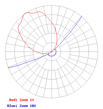 | ||||||||||||||||||
| Azimuth | Ratio | Azimuth | Ratio | Azimuth | Ratio | Azimuth | Ratio | ||||||||||||
| 5 | 0.555 | 15 | 0.410 | 25 | 0.280 | 35 | 0.190 | ||||||||||||
| 45 | 0.048 | 55 | 0.010 | 65 | 0.010 | 75 | 0.010 | ||||||||||||
| 85 | 0.010 | 95 | 0.010 | 105 | 0.010 | 115 | 0.010 | ||||||||||||
| 125 | 0.010 | 135 | 0.010 | 145 | 0.010 | 155 | 0.010 | ||||||||||||
| 165 | 0.010 | 175 | 0.010 | 185 | 0.010 | 195 | 0.010 | ||||||||||||
| 205 | 0.010 | 215 | 0.010 | 225 | 0.010 | 235 | 0.010 | ||||||||||||
| 245 | 0.048 | 255 | 0.190 | 265 | 0.280 | 275 | 0.410 | ||||||||||||
| 285 | 0.550 | 295 | 0.710 | 305 | 0.880 | 315 | 0.917 | ||||||||||||
| 325 | 1.000 | 335 | 0.917 | 345 | 0.880 | 355 | 0.710 | ||||||||||||
Structure Registration Number 1223383 Structure Type: TOWER Registered To: American Towers LLC Structure Address: 1682 Highway 416 East (audubon Ky, # 88557) Henderson, KY County Name: Henderson County ASR Issued: 01/15/2013 Date Built: 03/07/2001 Site Elevation: 157 m (515 ft.) Structure Height: 99.1 m (325 ft.) Height Overall: 99.1 m (325 ft.) Overall Height AMSL: 256.1 m (840 ft.) FAA Determination: 12/05/2003 FAA Study #: 2003-ASO-5669-OE FAA Circular #: 70/7460-1H Paint & Light FAA Chapters: 4, 8, 13 OM&L to remain the same as prior study = A MED-DUAL SYSTEM 37-44-47.4 N 87-25-08.3 W (NAD 83) 37-44-47.2 N 87-25-08.3 W (Converted to NAD 27) |
406 Copeland Drive Cedar Hill, TX 75104 Phone: 972-291-3750 Limited Liability Company | Title: Member/manager Date: 08/23/2022 Application Certifier EICB-TV EAST, LLC Eicb-tv East, Llc 406 Copeland Drive Cedar Hill, TX 75104 Applicant Susan Hansen B. W. St. Clair 2305 Vida Shaw Rd New Iberia, LA 70563 CONSULTANT Ari Meltzer Wiley Rein Llp 2050 M St Nw Washington, DC 20036 Josh Weiss Ark Multicasting, Inc. Cedar Hill, TX 75106 CEO Caleb Weiss Ark Mediacom, Inc. Cedar Hill, TX 75106 President | |||||||||||||||||