
FCCInfo.com
A Service of Cavell, Mertz & Associates, Inc.
(855) FCC-INFO
|
|
WWCW from 04/04/1983 |
Post-repack Channel 21 Virtual Channel 21 |  |
|
||||||||||||||||
|
|
Repacking Information: Pre-Repack Channel: 20 Post-Repack Channel: 21 Post-Repack ERP: 938 kW Phase: 5 Completion Deadline: 9/11/2019 Upstream/Downstream Dependencies Other Linked Stations Find nearby TV Facilities Status: License Application Accepted: 09/07/2022 License Expires: 10/01/2028 File Number: -0000199504 FCC Website Links: LMS Facility Details This Application Other WWCW Applications Including Superseded Applications Mailing Address Correspondence for WWCW Correspondence related to application -0000199504 Service Contour - Open Street Map or USGS Map (41 dBu) Service Contour - KML / Google Earth (41 dBu) Public Inspection Files Rabbit Ears Info Search for WWCW Site Location: 37-19-15.0 N 79-37-57.0 W (NAD 83) Site Location: 37-19-14.5 N 79-37-57.9 W (Converted to NAD 27) ERP: 938 kW Polarization: Horizontally polarized HAAT: 503.1 m (1651 ft.) Electrical Beam Tilt: 0.65 degrees R/C AGL: 259.8 m (852 ft.) R/C AMSL: 833.7 m (2735 ft.) Site Elevation: 573.9 m. (1883 ft.) Height Overall*: 275.5 m (904 ft.) (* As Filed In This Application, may differ from ASR Data, Below.) Directional Antenna - Antenna Make/Model: Electronics Research Inc. ATW23H4-HTC1-20/21H Antenna ID: 1010036 Polarization: Horizontally polarized | |||||||||||||||||||
| Antenna Data for Antenna Id: 1010036 WWCW DT File: -0000199504 Electronics Research Inc. - ATW23H4-HTC1-20/21H Service: DT Standard Pattern: N | 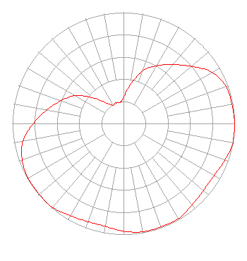 | |||||||||||||||||||
| Azimuth | Ratio | Azimuth | Ratio | Azimuth | Ratio | Azimuth | Ratio | |||||||||||||
| 0 | 0.230 | 10 | 0.350 | 20 | 0.500 | 30 | 0.600 | |||||||||||||
| 40 | 0.690 | 50 | 0.800 | 60 | 0.920 | 70 | 0.980 | |||||||||||||
| 80 | 0.990 | 90 | 1.000 | 100 | 1.000 | 110 | 0.970 | |||||||||||||
| 120 | 0.940 | 130 | 0.940 | 140 | 0.960 | 150 | 0.990 | |||||||||||||
| 160 | 0.990 | 170 | 0.990 | 180 | 0.970 | 190 | 0.940 | |||||||||||||
| 200 | 0.940 | 210 | 0.960 | 220 | 0.990 | 230 | 0.990 | |||||||||||||
| 240 | 0.990 | 250 | 0.970 | 260 | 0.920 | 270 | 0.810 | |||||||||||||
| 280 | 0.700 | 290 | 0.600 | 300 | 0.500 | 310 | 0.360 | |||||||||||||
| 320 | 0.240 | 330 | 0.190 | 340 | 0.200 | 350 | 0.190 | |||||||||||||
Structure Registration Number 1026679 Structure Type: TOWER Registered To: Nexstar Media Inc. Structure Address: 9.98 Km W Of Bedford County At Flattop Mountain Bedford, VA County Name: Bedford County ASR Issued: 05/28/2021 Date Built: 06/17/1993 Site Elevation: 573.9 m (1883 ft.) Structure Height: 253 m (830 ft.) Height Overall: 275.5 m (904 ft.) Overall Height AMSL: 849.4 m (2787 ft.) FAA Determination: 06/09/1997 FAA Study #: 97-AEA-0744-OE FAA Circular #: 70/7460-1J Paint & Light FAA Chapters: 4, 7, 13 37-19-15.0 N 79-37-57.0 W (NAD 83) 37-19-14.5 N 79-37-57.9 W (Converted to NAD 27) |
545 E. John Carpenter Freeway Suite 700 Irving, TX 75062 Phone: 972-373-8800 Corporation | Title: Associate General Counsel Date: 09/07/2022 Application Certifier Nexstar Media Inc. 545 E. John Carpenter Freeway Suite 700 Irving, TX 75062 Applicant William T. Godfrey, Jr Kessler And Gehman Associates, Inc. Kessler And Gehman Associates, Inc. 507-d Nw 60th Street Gainesville, FL 32607 Consulting Engineers Jason Roberts Nexstar Media Inc. 545 E John Carpenter Freeway Suite 700 Irving, TX 75062 Associate General Counsel | ||||||||||||||||||
| ||||||||||||||||||||
