
FCCInfo.com
A Service of Cavell, Mertz & Associates, Inc.
(855) FCC-INFO
|
|
K22OB-D from 02/25/2010 |
|
|
||||||||||||||||
|
|
Status: License Application Accepted: 09/22/2022 License Expires: 02/01/2023 File Number: -0000200779 FCC Website Links: LMS Facility Details This Application Other K22OB-D Applications Including Superseded Applications Mailing Address Correspondence for K22OB-D Correspondence related to application -0000200779 Service Contour - Open Street Map or USGS Map (51 dBu) Service Contour - KML / Google Earth (51 dBu) Rabbit Ears Info Search for K22OB-D Site Location: 42-26-47.0 N 123-03-26.3 W (NAD 83) Site Location: 42-26-47.6 N 123-03-22.1 W (Converted to NAD 27) ERP: 0.1 kW Polarization: Horizontally polarized Electrical Beam Tilt: 1.75 degrees R/C AGL: 30 m (98 ft.) R/C AMSL: 771.4 m (2531 ft.) Emission Mask: Full Service Site Elevation: 741.4 m. (2432 ft.) Height Overall*: 35.6 m (117 ft.) (* As Filed In This Application, may differ from ASR Data, Below.) Directional Antenna - Antenna Make/Model: Propagation System Inc PSIUCB4EC Antenna ID: 95158 Polarization: Horizontally polarized | ||||||||||||||||||
| Antenna Data for Antenna Id: 95158 K22OB-D LD File: -0000200779 Propagation System Inc - PSIUCB4EC Service: LD Standard Pattern: Y Pattern and Field Values Include a 85° Clockwise Rotation | 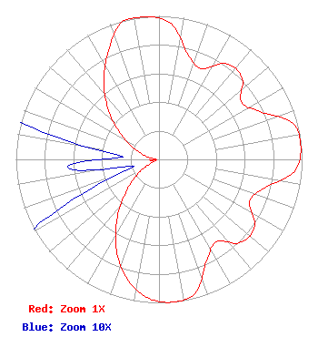 | ||||||||||||||||||
| Azimuth | Ratio | Azimuth | Ratio | Azimuth | Ratio | Azimuth | Ratio | ||||||||||||
| 5 | 0.950 | 15 | 0.765 | 25 | 0.698 | 35 | 0.815 | ||||||||||||
| 45 | 0.816 | 55 | 0.702 | 65 | 0.782 | 75 | 0.967 | ||||||||||||
| 85 | 0.995 | 95 | 0.950 | 105 | 0.765 | 115 | 0.698 | ||||||||||||
| 125 | 0.815 | 135 | 0.816 | 145 | 0.702 | 155 | 0.782 | ||||||||||||
| 165 | 0.967 | 175 | 1.000 | 185 | 0.967 | 195 | 0.861 | ||||||||||||
| 205 | 0.701 | 215 | 0.513 | 225 | 0.330 | 235 | 0.182 | ||||||||||||
| 245 | 0.066 | 255 | 0.018 | 265 | 0.064 | 275 | 0.026 | ||||||||||||
| 285 | 0.101 | 295 | 0.208 | 305 | 0.345 | 315 | 0.507 | ||||||||||||
| 325 | 0.673 | 335 | 0.835 | 345 | 0.995 | 355 | 1.000 | ||||||||||||
Structure Registration Number 1230251 Structure Type: TOWER Registered To: SpectraSite Communications, LLC. through American Towers, LLC. Structure Address: 1700 West 7th Street Gold Hill, OR County Name: Jackson County ASR Issued: 01/16/2013 Date Built: 10/01/2001 Site Elevation: 741.4 m (2432 ft.) Structure Height: 30.4 m (100 ft.) Height Overall: 35.6 m (117 ft.) Overall Height AMSL: 777 m (2549 ft.) FAA Determination: 06/12/2003 FAA Study #: 2003-ANM-1116-OE FAA Circular #: 70/7460-1K Paint & Light FAA Chapters: 4, 5, 12 PRIOR STUDY 2001-ANM-3529-OE 42-26-47.0 N 123-03-26.3 W (NAD 83) 42-26-47.6 N 123-03-22.1 W (Converted to NAD 27) |
23145 Alfalfa Market Road Bend, OR 97701 Phone: 541-639-6090 Limited Liability Company | Title: President Date: 09/22/2022 Application Certifier SPECTRUM EVOLUTION, INC. Spectrum Evolution, Inc. 855 Harbor Court Southlake, TX 76092 Applicant Jesus Ortega Broadcast Engineering Services 60891 Robinette Road Saint Helens, OR 97501 ENGINEERING CONSULTANT Kathleen Victory Fletcher, Heald, & Hildreth, P.l.c. 1300 North 17th Street Suite 1100 Arlington, VA 22209 | |||||||||||||||||
