
FCCInfo.com
A Service of Cavell, Mertz & Associates, Inc.
(855) FCC-INFO
|
|
KRJR-LD from 05/12/2006 KRJR-LD from 08/30/2002 KRJR-LD from 02/08/1990 |
|
|
||||||||||||||||
|
|
Status: License Application Accepted: 11/14/2022 License Expires: 12/01/2022 File Number: -0000203475 FCC Website Links: LMS Facility Details This Application Other KRJR-LD Applications Including Superseded Applications Mailing Address Correspondence for KRJR-LD Correspondence related to application -0000203475 Service Contour - Open Street Map or USGS Map (48 dBu) Service Contour - KML / Google Earth (48 dBu) Rabbit Ears Info Search for KRJR-LD Site Location: 38-38-53.0 N 121-28-41.4 W (NAD 83) Site Location: 38-38-53.3 N 121-28-37.6 W (Converted to NAD 27) ERP: 3 kW Polarization: Circularly polarized R/C AGL: 151 m (495 ft.) R/C AMSL: 158.3 m (519 ft.) Emission Mask: Full Service Site Elevation: 7.3 m. (24 ft.) Height Overall*: 165.2 m (542 ft.) (* As Filed In This Application, may differ from ASR Data, Below.) Directional Antenna - Antenna Make/Model: Systems With Reliability Inc. SWCVL4EC Antenna ID: 1010219 Polarization: Circularly polarized | ||||||||||||||||||
| Antenna Data for Antenna Id: 1010219 KRJR-LD LD File: -0000203475 Systems With Reliability Inc. - SWCVL4EC Service: LD Standard Pattern: N Pattern and Field Values Include a 60° Clockwise Rotation | 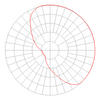 | ||||||||||||||||||
| Azimuth | Ratio | Azimuth | Ratio | Azimuth | Ratio | Azimuth | Ratio | ||||||||||||
| 0 | 1.000 | 10 | 1.000 | 20 | 1.000 | 30 | 1.000 | ||||||||||||
| 40 | 1.000 | 50 | 1.000 | 60 | 1.000 | 70 | 1.000 | ||||||||||||
| 80 | 1.000 | 90 | 1.000 | 100 | 1.000 | 110 | 1.000 | ||||||||||||
| 120 | 1.000 | 130 | 1.000 | 140 | 0.980 | 150 | 0.860 | ||||||||||||
| 160 | 0.670 | 170 | 0.520 | 180 | 0.420 | 190 | 0.330 | ||||||||||||
| 200 | 0.260 | 210 | 0.200 | 220 | 0.170 | 230 | 0.170 | ||||||||||||
| 240 | 0.170 | 250 | 0.170 | 260 | 0.170 | 270 | 0.200 | ||||||||||||
| 280 | 0.260 | 290 | 0.330 | 300 | 0.420 | 310 | 0.520 | ||||||||||||
| 320 | 0.670 | 330 | 0.860 | 340 | 0.960 | 350 | 1.000 | ||||||||||||
Structure Registration Number 1038784 Structure Type: LTOWER Registered To: American Towers LLC Structure Address: 719 North Market Blvd. Sacramento, CA County Name: Sacramento County ASR Issued: 11/18/2022 Date Built: 12/10/1987 Site Elevation: 7.3 m (24 ft.) Structure Height: 164.3 m (539 ft.) Height Overall: 165.2 m (542 ft.) Overall Height AMSL: 172.5 m (566 ft.) FAA Determination: 11/10/2022 FAA Study #: 2022-AWP-10560-OE Paint & Light FAA Chapters: 1, 3, 4, 13, 21 Continue As Is OM&L = PAINT/RED LIGHTS 38-38-53.0 N 121-28-41.4 W (NAD 83) 38-38-53.3 N 121-28-37.6 W (Converted to NAD 27) |
3901 Highway 121 South Bedford, TX 76021 Phone: 817-571-1229 Applicant | Title: Manager Date: 11/14/2022 Application Certifier WORD OF GOD FELLOWSHIP, INC. Word Of God Fellowship, Inc. 3901 Highway 121 South Bedford, TX 76021 Applicant RICHARD C GOETZ R & L Media Systems 135 N Country Club Dr Hendersonville, TN 37075 BROADCAST CONSULTANT Ari Meltzer Wiley Rein Llp 2050 M Street Nw Washington, DC 20036 ARNOLD TORRES Word Of God Fellowship, Inc. 3901 Highway 121 South Bedford, TX 76021 | |||||||||||||||||