
FCCInfo.com
A Service of Cavell, Mertz & Associates, Inc.
(855) FCC-INFO
|
|
WUPL from 11/21/1994 |
Post-repack Channel 17 Virtual Channel 54 |  |
|
||||||||||||||||
|
|
Repacking Information: Pre-Repack Channel: 24 Post-Repack Channel: 17 Post-Repack ERP: 848 kW Phase: 7 Completion Deadline: 1/17/2020 Upstream/Downstream Dependencies Other Linked Stations Find nearby TV Facilities Status: License Application Accepted: 11/16/2022 License Expires: 06/01/2021 File Number: -0000203658 FCC Website Links: LMS Facility Details This Application Other WUPL Applications Including Superseded Applications Mailing Address Correspondence for WUPL Correspondence related to application -0000203658 Service Contour - Open Street Map or USGS Map (41 dBu) Service Contour - KML / Google Earth (41 dBu) Public Inspection Files Rabbit Ears Info Search for WUPL Site Location: 29-54-22.9 N 90-02-22.1 W (NAD 83) Site Location: 29-54-22.2 N 90-02-21.8 W (Converted to NAD 27) ERP: 850 kW Polarization: Elliptically polarized HAAT: 295.8 m (970 ft.) Electrical Beam Tilt: 0.75 degrees R/C AGL: 295.7 m (970 ft.) R/C AMSL: 296 m (971 ft.) Site Elevation: 0.3 m. (1 ft.) Height Overall*: 319.4 m (1048 ft.) (* As Filed In This Application, may differ from ASR Data, Below.) Directional Antenna - Antenna Make/Model: Dielectric TFU-21JSC/VP-R C180 Antenna ID: 1010239 Polarization: Elliptically polarized | |||||||||||||||||||
| Antenna Data for Antenna Id: 1010239 WUPL DT File: -0000203658 Dielectric - TFU-21JSC/VP-R C180 Service: DT Standard Pattern: N | 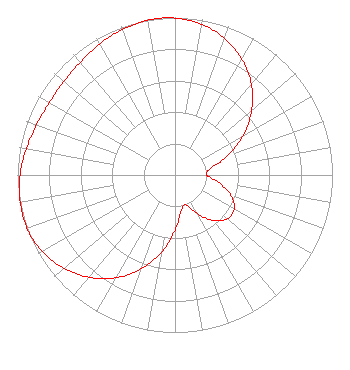 | |||||||||||||||||||
| Azimuth | Ratio | Azimuth | Ratio | Azimuth | Ratio | Azimuth | Ratio | |||||||||||||
| 0 | 0.996 | 10 | 0.972 | 20 | 0.922 | 30 | 0.849 | |||||||||||||
| 40 | 0.753 | 50 | 0.635 | 60 | 0.499 | 70 | 0.353 | |||||||||||||
| 80 | 0.228 | 90 | 0.201 | 100 | 0.284 | 110 | 0.378 | |||||||||||||
| 120 | 0.433 | 130 | 0.433 | 140 | 0.378 | 150 | 0.284 | |||||||||||||
| 160 | 0.201 | 170 | 0.228 | 180 | 0.353 | 190 | 0.499 | |||||||||||||
| 200 | 0.635 | 210 | 0.753 | 220 | 0.849 | 230 | 0.922 | |||||||||||||
| 240 | 0.972 | 250 | 1.000 | 260 | 0.998 | 270 | 0.983 | |||||||||||||
| 280 | 0.959 | 290 | 0.935 | 300 | 0.921 | 310 | 0.921 | |||||||||||||
| 320 | 0.935 | 330 | 0.959 | 340 | 0.983 | 350 | 0.998 | |||||||||||||
| 354 | 1.000 | |||||||||||||||||||
Structure Registration Number 1220144 Structure Type: TOWER Registered To: WWL-TV, Inc. Structure Address: No. 4 Cooper Road (off Whitney Avenue) Gretna, LA County Name: Jefferson Parish ASR Issued: 02/13/2019 Date Built: 12/14/2001 Site Elevation: 0.3 m (1 ft.) Structure Height: 319.4 m (1048 ft.) Height Overall: 319.4 m (1048 ft.) Overall Height AMSL: 319.7 m (1049 ft.) FAA Determination: 09/08/2000 FAA Study #: 00-ASW-4167-OE FAA Circular #: 70/7460-1K Paint & Light FAA Chapters: 4, 9, 12 Removed expiration date from determination. Scenario 1./jjs/case#635066 29-54-22.9 N 90-02-22.1 W (NAD 83) 29-54-22.2 N 90-02-21.8 W (Converted to NAD 27) |
Tegna Inc. 8350 Broad Street, Suite 2000 Tysons, VA 22102 Phone: 703-873-6606 Corporation | Title: Secretary Date: 11/16/2022 Application Certifier Belo Tv, Inc. Tegna Inc. 8350 Broad Street, Suite 2000 Tysons, VA 22102 Applicant Michael Beder, Esq. Tegna Inc. 8350 Broad Street, Suite 2000 Tysons, VA 22102 Associate General Counsel William T. Godfrey, Jr Kessler And Gehman Associates, Inc. Kessler And Gehman Associates, Inc. 507-d Nw 60th Street Gainesville, FL 32607 Consulting Engineers | ||||||||||||||||||
| ||||||||||||||||||||
