
FCCInfo.com
A Service of Cavell, Mertz & Associates, Inc.
(855) FCC-INFO
|
|
|
Post-repack Channel 34 Virtual Channel 3 |  |
|
|||||||||||||||||||||
|
|
Repacking Information: Pre-Repack Channel: 48 Post-Repack Channel: 34 Post-Repack ERP: 767 kW Phase: 7 Completion Deadline: 1/17/2020 Find nearby TV Facilities Status: License Application Accepted: 11/16/2022 License Expires: 12/01/2021 File Number: -0000203664 FCC Website Links: LMS Facility Details This Application Other WCIA Applications Including Superseded Applications Mailing Address Correspondence for WCIA Correspondence related to application -0000203664 Service Contour - Open Street Map or USGS Map (41 dBu) Service Contour - KML / Google Earth (41 dBu) Public Inspection Files History Cards for WCIA Rabbit Ears Info Search for WCIA Site Location: 40-06-21.0 N 88-27-00.0 W (NAD 83) Site Location: 40-06-20.9 N 88-26-59.8 W (Converted to NAD 27) ERP: 681 kW Polarization: Elliptically polarized HAAT: 285.1 m (935 ft.) Electrical Beam Tilt: 0.75 degrees R/C AGL: 281.1 m (922 ft.) R/C AMSL: 501.2 m (1644 ft.) Site Elevation: 220.1 m. (722 ft.) Height Overall*: 300.2 m (985 ft.) (* As Filed In This Application, may differ from ASR Data, Below.) Directional Antenna - Antenna Make/Model: Dielectric TFU-27ETT/VP-R 04 SP Antenna ID: 1010240 Polarization: Elliptically polarized | ||||||||||||||||||||||||
| Antenna Data for Antenna Id: 1010240 WCIA DT File: -0000203664 Dielectric - TFU-27ETT/VP-R 04 SP Service: DT Standard Pattern: N | 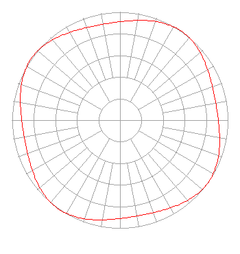 | ||||||||||||||||||||||||
| Azimuth | Ratio | Azimuth | Ratio | Azimuth | Ratio | Azimuth | Ratio | ||||||||||||||||||
| 0 | 0.910 | 10 | 0.936 | 20 | 0.971 | 30 | 0.996 | ||||||||||||||||||
| 35 | 1.000 | 40 | 0.996 | 50 | 0.971 | 60 | 0.936 | ||||||||||||||||||
| 70 | 0.910 | 80 | 0.901 | 90 | 0.910 | 100 | 0.936 | ||||||||||||||||||
| 110 | 0.971 | 120 | 0.996 | 125 | 1.000 | 130 | 0.996 | ||||||||||||||||||
| 140 | 0.971 | 150 | 0.936 | 160 | 0.910 | 170 | 0.901 | ||||||||||||||||||
| 180 | 0.910 | 190 | 0.936 | 200 | 0.971 | 210 | 0.996 | ||||||||||||||||||
| 215 | 1.000 | 220 | 0.996 | 230 | 0.971 | 240 | 0.936 | ||||||||||||||||||
| 250 | 0.910 | 260 | 0.901 | 270 | 0.910 | 280 | 0.936 | ||||||||||||||||||
| 290 | 0.971 | 300 | 0.996 | 305 | 1.000 | 310 | 0.996 | ||||||||||||||||||
| 320 | 0.971 | 330 | 0.936 | 340 | 0.910 | 350 | 0.901 | ||||||||||||||||||
Structure Registration Number 1016057 Structure Type: TOWER Registered To: Nexstar Media Inc. Structure Address: On St Hwy 10 10 Mi W Of Champaign Scott Township, IL County Name: Champaign County ASR Issued: 05/28/2021 Date Built: 01/01/1953 Site Elevation: 220.1 m (722 ft.) Structure Height: 269.6 m (885 ft.) Height Overall: 300.2 m (985 ft.) Overall Height AMSL: 520.3 m (1707 ft.) FAA Determination: 01/27/1997 FAA Study #: 96-AGL-4357-OE FAA Circular #: 70/7460-1J Paint & Light FAA Chapters: 3, 4, 5, 13 40-06-21.0 N 88-27-00.0 W (NAD 83) 40-06-20.9 N 88-26-59.8 W (Converted to NAD 27) |
545 E. John Carpenter Freeway Suite 700 Irving, TX 75062 Phone: 972-373-8800 Corporation | Title: Associate General Counsel Date: 11/16/2022 Application Certifier Nexstar Media Inc. 545 E. John Carpenter Freeway Suite 700 Irving, TX 75062 Applicant William T. Godfrey, Jr Kessler And Gehman Associates, Inc. Kessler And Gehman Associates, Inc. 507-d Nw 60th Street Gainesville, FL 32607 Consulting Engineers Jason Roberts Nexstar Media Inc. 545 E John Carpenter Freeway Suite 700 Irving, TX 75062 Associate General Counsel | |||||||||||||||||||||||
| |||||||||||||||||||||||||
