
FCCInfo.com
A Service of Cavell, Mertz & Associates, Inc.
(855) FCC-INFO
|
|
WSTE-DT from 02/18/1987 WSTE-DT from 03/28/1979 WSTE-DT from 07/21/1978 |
Virtual Channel 7 |
|
||||||||||||||||||||||||||||||||||||||||||||||||||||
|
|
Repacking Information: No changes Status: License Application Accepted: 10/17/2023 License Expires: 02/01/2029 File Number: -0000205614 FCC Website Links: LMS Facility Details This Application Other WSTE-DT Applications Including Superseded Applications Mailing Address Correspondence for WSTE-DT Correspondence related to application -0000205614 Service Contour - Open Street Map or USGS Map (36 dBu) Service Contour - KML / Google Earth (36 dBu) Public Inspection Files History Cards for WSTE-DT Rabbit Ears Info Search for WSTE-DT DTS Site Number: 4 Site Location: 18-27-14.0 N 66-45-15.0 W (NAD 83) Site Location: 18-27-21.2 N 66-45-16.4 W (Converted to NAD 27) ERP: 0.1 kW Polarization: Horizontally polarized HAAT: 65 m (213 ft.) R/C AGL: 85 m (279 ft.) R/C AMSL: 149 m (489 ft.) Site Elevation: 64 m. (210 ft.) Height Overall*: 91.1 m (299 ft.) (* As Filed In This Application, may differ from ASR Data, Below.) Directional Antenna - Antenna Make/Model: Alan Dick & Company Ltd. T7H1.3MS2S Antenna ID: 109675 Polarization: Horizontally polarized | ||||||||||||||||||||||||||||||||||||||||||||||||||||||
| Antenna Data for Antenna Id: 109675 WSTE-DT DD File: -0000205614 Alan Dick & Company Ltd. - T7H1.3MS2S Service: DD Standard Pattern: Y | 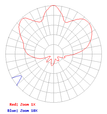 | ||||||||||||||||||||||||||||||||||||||||||||||||||||||
| Azimuth | Ratio | Azimuth | Ratio | Azimuth | Ratio | Azimuth | Ratio | ||||||||||||||||||||||||||||||||||||||||||||||||
| 0 | 1.000 | 10 | 0.870 | 20 | 0.700 | 30 | 0.790 | ||||||||||||||||||||||||||||||||||||||||||||||||
| 40 | 0.940 | 50 | 0.970 | 60 | 0.920 | 70 | 0.820 | ||||||||||||||||||||||||||||||||||||||||||||||||
| 80 | 0.680 | 90 | 0.450 | 100 | 0.250 | 110 | 0.240 | ||||||||||||||||||||||||||||||||||||||||||||||||
| 120 | 0.120 | 130 | 0.110 | 140 | 0.170 | 150 | 0.160 | ||||||||||||||||||||||||||||||||||||||||||||||||
| 160 | 0.110 | 170 | 0.150 | 180 | 0.210 | 190 | 0.240 | ||||||||||||||||||||||||||||||||||||||||||||||||
| 200 | 0.120 | 210 | 0.140 | 220 | 0.220 | 230 | 0.100 | ||||||||||||||||||||||||||||||||||||||||||||||||
| 240 | 0.100 | 250 | 0.280 | 260 | 0.410 | 270 | 0.540 | ||||||||||||||||||||||||||||||||||||||||||||||||
| 280 | 0.620 | 290 | 0.670 | 300 | 0.800 | 310 | 0.930 | ||||||||||||||||||||||||||||||||||||||||||||||||
| 320 | 0.960 | 330 | 0.780 | 340 | 0.720 | 350 | 0.890 | ||||||||||||||||||||||||||||||||||||||||||||||||
Structure Registration Number 1011025 Structure Type: TOWER Registered To: WSTE, LLC Structure Address: Rd 129 Ramal 653 Arecibo, PR County Name: Arecibo Municipio ASR Issued: 11/29/2023 Date Built: 01/01/1989 Site Elevation: 64 m (210 ft.) Structure Height: 90.5 m (297 ft.) Height Overall: 91.1 m (299 ft.) Overall Height AMSL: 155.1 m (509 ft.) FAA Determination: 07/05/1988 FAA Study #: 88-ASO-1455-OE FAA Circular #: 70/7460-1G Paint & Light FAA Chapters: 3, 4, 5, 9 RED LIGHTS/PAINT 18-27-14.0 N 66-45-15.0 W (NAD 83) 18-27-21.2 N 66-45-16.4 W (Converted to NAD 27) |
101 Constitution Avenue, Nw, Suite 800w Washington, DC 20001 Phone: 310-348-3600 Limited Liability Company | Title: Senior Vice President Us Regulatory Date: 12/15/2022 Application Certifier WLII/WSUR LICENSE PARTNERSHIP, G.P. Wlii/wsur License Partnership, G.p. 101 Constitution Avenue, Nw, Suite 800w Washington, DC 20001 Applicant MATTHEW S. DELNERO Covington & Burling Llp One Citycenter 850 Tenth Street, Nw Washington, DC 20001 | |||||||||||||||||||||||||||||||||||||||||||||||||||||
|
| ||||||||||||||||||||||||||||||||||||||||||||||||||||||