
FCCInfo.com
A Service of Cavell, Mertz & Associates, Inc.
(855) FCC-INFO
|
|
|
|
|
||||||||||||||||
|
|
Status: License Application Accepted: 11/21/2022 License Expires: 02/01/2029 File Number: -0000203935 FCC Website Links: LMS Facility Details This Application Other WJVF-LD Applications Including Superseded Applications Mailing Address Correspondence for WJVF-LD Correspondence related to application -0000203935 Service Contour - Open Street Map or USGS Map (51 dBu) Service Contour - KML / Google Earth (51 dBu) Rabbit Ears Info Search for WJVF-LD Site Location: 30-16-36.8 N 81-33-57.0 W (NAD 83) Site Location: 30-16-35.9 N 81-33-57.7 W (Converted to NAD 27) ERP: 15 kW Polarization: Horizontally polarized Electrical Beam Tilt: 1.0 degree R/C AGL: 228.1 m (748 ft.) R/C AMSL: 236 m (774 ft.) Emission Mask: Full Service Site Elevation: 7.9 m. (26 ft.) Height Overall*: 305.3 m (1002 ft.) (* As Filed In This Application, may differ from ASR Data, Below.) Directional Antenna - Antenna Make/Model: Propagation System Inc PSILP16EC-MOD Antenna ID: 1010259 Polarization: Horizontally polarized | ||||||||||||||||||
| Antenna Data for Antenna Id: 1010259 WJVF-LD LD File: -0000203935 Propagation System Inc - PSILP16EC-MOD Service: LD Standard Pattern: N Pattern and Field Values Include a 265° Clockwise Rotation | 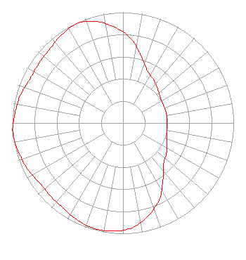 | ||||||||||||||||||
| Azimuth | Ratio | Azimuth | Ratio | Azimuth | Ratio | Azimuth | Ratio | ||||||||||||
| 5 | 0.770 | 15 | 0.630 | 25 | 0.520 | 35 | 0.480 | ||||||||||||
| 45 | 0.440 | 55 | 0.410 | 65 | 0.400 | 75 | 0.400 | ||||||||||||
| 85 | 0.400 | 95 | 0.400 | 105 | 0.410 | 115 | 0.440 | ||||||||||||
| 125 | 0.480 | 135 | 0.520 | 145 | 0.630 | 155 | 0.770 | ||||||||||||
| 165 | 0.870 | 175 | 0.950 | 185 | 0.980 | 195 | 0.990 | ||||||||||||
| 205 | 0.970 | 215 | 0.940 | 225 | 0.930 | 235 | 0.930 | ||||||||||||
| 245 | 0.960 | 255 | 0.980 | 265 | 1.000 | 275 | 0.980 | ||||||||||||
| 285 | 0.960 | 295 | 0.930 | 305 | 0.930 | 315 | 0.940 | ||||||||||||
| 325 | 0.970 | 335 | 0.990 | 345 | 0.950 | 355 | 0.870 | ||||||||||||
Structure Registration Number 1016457 Structure Type: GTOWER Registered To: American Towers LLC Structure Address: 9050 Hogan Road (#207748) Jacksonville, FL County Name: Duval County ASR Issued: 10/26/2022 Date Built: 07/01/1988 Site Elevation: 7.9 m (26 ft.) Structure Height: 289.8 m (951 ft.) Height Overall: 305.3 m (1002 ft.) Overall Height AMSL: 313.2 m (1028 ft.) FAA Determination: 11/16/2021 FAA Study #: 2021-ASO-25036-OE FAA Circular #: 70/7460-1M Paint & Light FAA Chapters: 4, 9, 15 PRIOR STUDY 1988-ASO-1533-OE 30-16-36.8 N 81-33-57.0 W (NAD 83) 30-16-35.9 N 81-33-57.7 W (Converted to NAD 27) |
Chattanooga, TN 37401 Phone: 423-468-5100 Limited Liability Company | Title: Coo Date: 11/21/2022 Application Certifier Digital Networks-southeast, Llc Chattanooga, TN 37401 Applicant Timothy Z Sawyer T Z Sawyer Technical Consultants 2130 Hutchison Grove Court Suite 100 Falls Church, VA 22043 Technical Consultant Aaron P Shainis Shainis & Peltzman, Chartered 1850 M Street Nw Suite 240 Washington, DC 20036 Legal Counsel | |||||||||||||||||