
FCCInfo.com
A Service of Cavell, Mertz & Associates, Inc.
(855) FCC-INFO
|
|
WIWN from 10/19/2004 WIWN from 08/02/1991 WIWN from 10/02/1989 |
Virtual Channel 68 |
|
||||||||||||||||
|
|
Repacking Information: No changes Status: Application Application Accepted: 11/29/2022 License Expires: 00/00/0000 File Number: -0000186370 FCC Website Links: LMS Facility Details This Application Other WIWN Applications Including Superseded Applications Mailing Address Correspondence for WIWN Correspondence related to application -0000186370 Service Contour - Open Street Map or USGS Map (36 dBu) Service Contour - KML / Google Earth (36 dBu) Public Inspection Files Rabbit Ears Info Search for WIWN Site Location: 43-05-46.2 N 87-54-15.0 W (NAD 83) Site Location: 43-05-46.2 N 87-54-14.7 W (Converted to NAD 27) ERP: 38 kW Polarization: Elliptically polarized HAAT: 338 m (1109 ft.) Electrical Beam Tilt: 2.0 degrees R/C AGL: 345.3 m (1133 ft.) R/C AMSL: 536.7 m (1761 ft.) Site Elevation: 191.4 m. (628 ft.) Height Overall*: 369.7 m (1213 ft.) (* As Filed In This Application, may differ from ASR Data, Below.) Directional Antenna - Antenna Make/Model: Alive ATC-BCE86CPSV1-7 Antenna ID: 1009404 Polarization: Elliptically polarized | ||||||||||||||||||
| Antenna Data for Antenna Id: 1009404 WIWN DT File: -0000186370 Alive - ATC-BCE86CPSV1-7 Service: DT Standard Pattern: N Pattern and Field Values Include a 210° Clockwise Rotation | 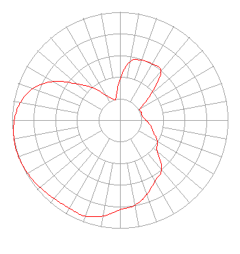 | ||||||||||||||||||
| Azimuth | Ratio | Azimuth | Ratio | Azimuth | Ratio | Azimuth | Ratio | ||||||||||||
| 0 | 0.380 | 10 | 0.551 | 20 | 0.590 | 30 | 0.600 | ||||||||||||
| 40 | 0.590 | 50 | 0.370 | 60 | 0.220 | 70 | 0.210 | ||||||||||||
| 80 | 0.210 | 90 | 0.240 | 100 | 0.287 | 110 | 0.330 | ||||||||||||
| 120 | 0.400 | 130 | 0.450 | 140 | 0.600 | 150 | 0.650 | ||||||||||||
| 160 | 0.730 | 170 | 0.800 | 180 | 0.830 | 190 | 0.900 | ||||||||||||
| 200 | 0.944 | 210 | 0.940 | 220 | 0.948 | 230 | 0.968 | ||||||||||||
| 240 | 0.986 | 250 | 1.000 | 260 | 0.997 | 270 | 0.979 | ||||||||||||
| 280 | 0.937 | 290 | 0.857 | 300 | 0.715 | 310 | 0.520 | ||||||||||||
| 320 | 0.390 | 330 | 0.270 | 340 | 0.210 | 350 | 0.210 | ||||||||||||
Structure Registration Number 1057482 Structure Type: GTOWER Registered To: Milwaukee Area Technical College District Board Structure Address: 4350a N Humboldt Ave/atc Site-milwaukee/#075054 Milwaukee-53212, WI County Name: Milwaukee County ASR Issued: 08/26/2022 Date Built: 05/27/2015 Site Elevation: 191.4 m (628 ft.) Structure Height: 334.9 m (1099 ft.) Height Overall: 369.7 m (1213 ft.) Overall Height AMSL: 561.1 m (1841 ft.) FAA Determination: 07/03/2014 FAA Study #: 2014-AGL-6435-OE FAA Circular #: 70/7460-1K Paint & Light FAA Chapters: 4, 9, 12 PRIOR STUDY 2013-AGL-9774-OE 43-05-46.2 N 87-54-15.0 W (NAD 83) 43-05-46.2 N 87-54-14.7 W (Converted to NAD 27) |
8919 World Ministry Avenue Baton Rouge, LA 70810 Phone: 225-768-8300 Not-for-Profit | Title: President Date: 11/29/2022 Application Certifier MILWAUKEE MEDIA LLC Milwaukee Media Llc P.o. Box 1756 Pacific Palisades, CA 90272 Applicant Ari Meltzer Wiley Rein Llp 2050 M Street Nw Washington, DC 20036 Greg Best Greg Best Consulting, Inc. 16100 Outlook Ave Stilwell, KS 66085 President | |||||||||||||||||