
FCCInfo.com
A Service of Cavell, Mertz & Associates, Inc.
(855) FCC-INFO
|
|
WANF-LD from 02/22/2011 |
|
|
||||||||||||||||
|
|
Status: License Application Accepted: 12/27/2022 License Expires: 08/01/2029 File Number: -0000205962 FCC Website Links: LMS Facility Details This Application Other WANF-LD Applications Including Superseded Applications Mailing Address Correspondence for WANF-LD Correspondence related to application -0000205962 Service Contour - Open Street Map or USGS Map (51 dBu) Service Contour - KML / Google Earth (51 dBu) Rabbit Ears Info Search for WANF-LD Site Location: 36-04-38.6 N 89-29-28.2 W (NAD 83) Site Location: 36-04-38.3 N 89-29-27.9 W (Converted to NAD 27) ERP: 10 kW Polarization: Horizontally polarized Electrical Beam Tilt: 0.5 degrees R/C AGL: 65.2 m (214 ft.) R/C AMSL: 206 m (676 ft.) Emission Mask: Full Service Site Elevation: 140.8 m. (462 ft.) Height Overall*: 79.2 m (260 ft.) (* As Filed In This Application, may differ from ASR Data, Below.) Directional Antenna - Antenna Make/Model: Dielectric TLP-6E Antenna ID: 1010337 Polarization: Horizontally polarized | ||||||||||||||||||
| Antenna Data for Antenna Id: 1010337 WANF-LD LD File: -0000205962 Dielectric - TLP-6E Service: LD Standard Pattern: N Pattern and Field Values Include a 110° Clockwise Rotation | 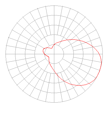 | ||||||||||||||||||
| Azimuth | Ratio | Azimuth | Ratio | Azimuth | Ratio | Azimuth | Ratio | ||||||||||||
| 0 | 0.190 | 10 | 0.222 | 20 | 0.254 | 30 | 0.301 | ||||||||||||
| 40 | 0.369 | 50 | 0.459 | 60 | 0.570 | 70 | 0.693 | ||||||||||||
| 80 | 0.820 | 90 | 0.928 | 100 | 0.988 | 110 | 1.000 | ||||||||||||
| 120 | 0.995 | 130 | 0.945 | 140 | 0.848 | 150 | 0.725 | ||||||||||||
| 160 | 0.590 | 170 | 0.457 | 180 | 0.346 | 190 | 0.277 | ||||||||||||
| 200 | 0.231 | 210 | 0.195 | 220 | 0.162 | 230 | 0.137 | ||||||||||||
| 240 | 0.127 | 250 | 0.139 | 260 | 0.166 | 270 | 0.198 | ||||||||||||
| 280 | 0.225 | 290 | 0.240 | 300 | 0.226 | 310 | 0.197 | ||||||||||||
| 320 | 0.164 | 330 | 0.136 | 340 | 0.128 | 350 | 0.153 | ||||||||||||
Structure Registration Number 1281655 Structure Type: TOWER Registered To: Global Tower, LLC. through American Towers, LLC Structure Address: 220 Perciful Road Dyersburg, TN County Name: Dyer County ASR Issued: 08/29/2014 Date Built: 02/24/2012 Site Elevation: 140.8 m (462 ft.) Structure Height: 79.2 m (260 ft.) Height Overall: 79.2 m (260 ft.) Overall Height AMSL: 220 m (722 ft.) FAA Determination: 11/14/2011 FAA Study #: 2011-ASO-6974-OE FAA Circular #: 70/7460-1K Paint & Light FAA Chapters: 4, 8, 12 Removed expiration date from determination. Scenario 1./jjs/case#635066 36-04-38.6 N 89-29-28.2 W (NAD 83) 36-04-38.3 N 89-29-27.9 W (Converted to NAD 27) |
4370 Peachtree Rd., Ne Atlanta, GA 30319 Phone: 404-504-9828 Limited Liability Company | Title: Assistant Secretary Date: 12/27/2022 Application Certifier Gray Television Licensee, Llc 4370 Peachtree Rd., Ne Atlanta, GA 30319 Applicant Joseph M. Davis, P.E. Chesapeake Rf Consultants, Llc 207 Old Dominion Road Yorktown, VA 23692 Consulting Engineer Joan Stewart Wiley Rein Llp 2050 M Street, Nw Washington, DC 20036 | |||||||||||||||||