
FCCInfo.com
A Service of Cavell, Mertz & Associates, Inc.
(855) FCC-INFO
|
|
KVTH-DT from 02/11/1994 KVTH-DT from 01/23/1984 |
Post-repack Channel 16 Virtual Channel 26 |
|
||||||||||||||||
|
|
Repacking Information: Pre-Repack Channel: 26 Post-Repack Channel: 16 Post-Repack ERP: 52.6 kW Phase: 1 Completion Deadline: 11/30/2018 Find nearby TV Facilities Status: License Application Accepted: 01/19/2023 License Expires: 06/01/2029 File Number: -0000207233 FCC Website Links: LMS Facility Details This Application Other KVTH-DT Applications Including Superseded Applications Mailing Address Correspondence for KVTH-DT Correspondence related to application -0000207233 Service Contour - Open Street Map or USGS Map (41 dBu) Service Contour - KML / Google Earth (41 dBu) Public Inspection Files Rabbit Ears Info Search for KVTH-DT Site Location: 34-22-20.0 N 93-02-49.0 W (NAD 83) Site Location: 34-22-19.7 N 93-02-48.4 W (Converted to NAD 27) ERP: 62 kW Polarization: Horizontally polarized HAAT: 224.7 m (737 ft.) Electrical Beam Tilt: 0.55 degrees R/C AGL: 91.4 m (300 ft.) R/C AMSL: 381 m (1250 ft.) Site Elevation: 289.6 m. (950 ft.) Height Overall*: 140.5 m (461 ft.) (* As Filed In This Application, may differ from ASR Data, Below.) Directional Antenna - Antenna Make/Model: Dielectric TFU-16WB-R S230 Antenna ID: 1010387 Polarization: Horizontally polarized | ||||||||||||||||||
| Antenna Data for Antenna Id: 1010387 KVTH-DT DX File: -0000207233 Dielectric - TFU-16WB-R S230 Service: DX Standard Pattern: N Pattern and Field Values Include a 190° Clockwise Rotation | 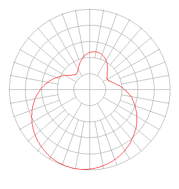 | ||||||||||||||||||
| Azimuth | Ratio | Azimuth | Ratio | Azimuth | Ratio | Azimuth | Ratio | ||||||||||||
| 0 | 0.458 | 10 | 0.474 | 20 | 0.458 | 30 | 0.412 | ||||||||||||
| 40 | 0.348 | 50 | 0.284 | 60 | 0.254 | 70 | 0.280 | ||||||||||||
| 80 | 0.348 | 90 | 0.434 | 100 | 0.523 | 110 | 0.600 | ||||||||||||
| 120 | 0.679 | 130 | 0.752 | 140 | 0.818 | 150 | 0.877 | ||||||||||||
| 160 | 0.926 | 170 | 0.965 | 180 | 0.990 | 190 | 1.000 | ||||||||||||
| 200 | 0.992 | 210 | 0.968 | 220 | 0.930 | 230 | 0.882 | ||||||||||||
| 240 | 0.824 | 250 | 0.758 | 260 | 0.686 | 270 | 0.606 | ||||||||||||
| 280 | 0.521 | 290 | 0.432 | 300 | 0.346 | 310 | 0.277 | ||||||||||||
| 320 | 0.252 | 330 | 0.284 | 340 | 0.348 | 350 | 0.413 | ||||||||||||
Structure Registration Number 1049466 Structure Type: TOWER Registered To: Victory Television Network, Inc. Structure Address: Jack Mountain, State Rd # 128; 10 Km South Of Hot Springs, AR County Name: Hot Spring County ASR Issued: 01/19/2016 Date Built: 01/01/1996 Site Elevation: 289.6 m (950 ft.) Structure Height: 122.2 m (401 ft.) Height Overall: 140.5 m (461 ft.) Overall Height AMSL: 430.1 m (1411 ft.) FAA Determination: 10/21/2010 FAA Study #: 2010-ASW-5757-OE FAA Circular #: 70/7460-1K Paint & Light FAA Chapters: 4, 6, 12 PRIOR STUDY 1998-ASW-427-OE 34-22-20.0 N 93-02-49.0 W (NAD 83) 34-22-19.7 N 93-02-48.4 W (Converted to NAD 27) |
P.o. Box 26207 Little Rock, AR 72221 Phone: 501-223-2525 Corporation | Title: President Date: 01/19/2023 Application Certifier VTN Victory Television Network, Inc. P.o. Box 26207 Little Rock, AR 72221 Applicant Gregory L. Masters, Esq Wiley Rein Llp 2050 M Street, N.w. Washington, DC 20036 | |||||||||||||||||