
FCCInfo.com
A Service of Cavell, Mertz & Associates, Inc.
(855) FCC-INFO
|
|
WAZS-LD from 03/16/2007 |
|
|
||||||||||||||||
|
|
Status: STA – Special Temporary Authority Application Accepted: 02/13/2023 STA Expires: 08/22/2023 File Number: -0000210693 FCC Website Links: LMS Facility Details This Application Other WAZS-LD Applications Including Superseded Applications Mailing Address Correspondence for WAZS-LD Correspondence related to application -0000210693 Service Contour - Open Street Map or USGS Map (51 dBu) Service Contour - KML / Google Earth (51 dBu) Rabbit Ears Info Search for WAZS-LD Site Location: 32-55-43.0 N 80-06-12.0 W (NAD 83) Site Location: 32-55-42.4 N 80-06-12.7 W (Converted to NAD 27) ERP: 0.04 kW Polarization: Horizontally polarized Electrical Beam Tilt: 0.5 degrees R/C AGL: 84.4 m (277 ft.) R/C AMSL: 93.8 m (308 ft.) Emission Mask: Stringent Site Elevation: 9.4 m. (31 ft.) Height Overall*: 100 m (328 ft.) (* As Filed In This Application, may differ from ASR Data, Below.) Directional Antenna - Antenna Make/Model: Aldena ATV-08-07-420 Antenna ID: 100207 Polarization: Horizontally polarized | ||||||||||||||||||
| Antenna Data for Antenna Id: 100207 WAZS-LD LD File: -0000210693 Aldena - ATV-08-07-420 Service: LD Standard Pattern: Y | 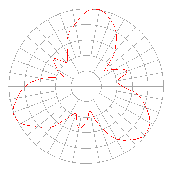 | ||||||||||||||||||
| Azimuth | Ratio | Azimuth | Ratio | Azimuth | Ratio | Azimuth | Ratio | ||||||||||||
| 0 | 0.955 | 10 | 1.000 | 20 | 0.912 | 30 | 0.785 | ||||||||||||
| 40 | 0.582 | 45 | 0.426 | 50 | 0.309 | 60 | 0.431 | ||||||||||||
| 70 | 0.562 | 80 | 0.422 | 90 | 0.473 | 100 | 0.684 | ||||||||||||
| 110 | 0.832 | 120 | 0.955 | 130 | 0.988 | 135 | 0.955 | ||||||||||||
| 140 | 0.902 | 150 | 0.785 | 160 | 0.569 | 170 | 0.331 | ||||||||||||
| 180 | 0.468 | 190 | 0.549 | 200 | 0.380 | 210 | 0.473 | ||||||||||||
| 220 | 0.692 | 225 | 0.767 | 230 | 0.822 | 240 | 0.966 | ||||||||||||
| 250 | 1.000 | 260 | 0.902 | 270 | 0.785 | 280 | 0.569 | ||||||||||||
| 290 | 0.309 | 300 | 0.431 | 310 | 0.543 | 315 | 0.479 | ||||||||||||
| 320 | 0.394 | 330 | 0.473 | 340 | 0.684 | 350 | 0.813 | ||||||||||||
Structure Registration Number 1054307 Structure Type: TOWER Registered To: THOMAS B. DANIELS Structure Address: N. Strayton Dr. 1.6 Km N. Of Ashley Church North Charleston, SC County Name: Dorchester County ASR Issued: 02/21/2001 Date Built: 02/15/2001 Site Elevation: 9.4 m (31 ft.) Structure Height: 99 m (325 ft.) Height Overall: 100 m (328 ft.) Overall Height AMSL: 109.4 m (359 ft.) FAA Determination: 03/27/2000 FAA Study #: 00-ASO-1299-OE Paint & Light FAA Chapters: A1, H, 3, 11, 21, 23 Removed expiration and final dates from determination. Scenario 2./jjs/case#635066 32-55-43.0 N 80-06-12.0 W (NAD 83) 32-55-42.4 N 80-06-12.7 W (Converted to NAD 27) |
4801 East Independence Blvd. Suite 815 Charlotte, NC 28212 Phone: 800-975-0760 Corporation | Title: Ceo Date: 02/13/2023 Application Certifier NORSAN COMMUNICATIONS AND MANAGEMENT, INC. Norsan Communications And Management, Inc. 4801 East Independence Blvd. Suite 815 Charlotte, NC 28212 Applicant Kevin T Fisher Smith And Fisher, Llc 4791 Wintergreen Court Woodbridge, VA 22192 Engineering Consultant John C Trent, Esq. Putbrese Hunsaker & Trent, P.c. 200 South Church Street Woodstock, VA 22664 FCC Counsel | |||||||||||||||||