
FCCInfo.com
A Service of Cavell, Mertz & Associates, Inc.
(855) FCC-INFO
|
|
KJYY-LD from 04/03/2017 KJYY-LD from 10/01/2013 KJYY-LD from 10/15/2009 KJYY-LD from 08/18/2004 KJYY-LD from 01/30/1987 |
Virtual Channel 29 |
|
|||||||||||||||||||
|
|
Status: License Application Accepted: 03/10/2023 License Expires: 02/03/2031 File Number: -0000212368 FCC Website Links: LMS Facility Details This Application Other KJYY-LD Applications Including Superseded Applications Mailing Address Correspondence for KJYY-LD Correspondence related to application -0000212368 Service Contour - Open Street Map or USGS Map (51 dBu) Service Contour - KML / Google Earth (51 dBu) Rabbit Ears Info Search for KJYY-LD Site Location: 45-30-57.8 N 122-44-03.1 W (NAD 83) Site Location: 45-30-58.4 N 122-43-58.7 W (Converted to NAD 27) ERP: 15 kW Polarization: Elliptically polarized Electrical Beam Tilt: 1.25 degrees R/C AGL: 248.1 m (814 ft.) R/C AMSL: 570.9 m (1873 ft.) Emission Mask: Full Service Site Elevation: 322.8 m. (1059 ft.) Height Overall*: 301.7 m (990 ft.) (* As Filed In This Application, may differ from ASR Data, Below.) Directional Antenna - Antenna Make/Model: ATC ATC-BCE514CT170-V4-29 Antenna ID: 1010536 Polarization: Elliptically polarized
| |||||||||||||||||||||
| Antenna Data for Antenna Id: 1010536 KJYY-LD LD File: -0000212368 ATC - ATC-BCE514CT170-V4-29 Service: LD Standard Pattern: N Pattern and Field Values Include a 12.5° Clockwise Rotation | 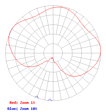 | |||||||||||||||||||||
| Azimuth | Ratio | Azimuth | Ratio | Azimuth | Ratio | Azimuth | Ratio | |||||||||||||||
| 2 | 0.957 | 12 | 0.975 | 22 | 0.957 | 32 | 0.912 | |||||||||||||||
| 42 | 0.867 | 52 | 0.856 | 62 | 0.893 | 72 | 0.954 | |||||||||||||||
| 82 | 1.000 | 92 | 0.991 | 102 | 0.942 | 112 | 0.870 | |||||||||||||||
| 122 | 0.797 | 132 | 0.719 | 142 | 0.608 | 152 | 0.443 | |||||||||||||||
| 162 | 0.241 | 172 | 0.200 | 182 | 0.100 | 192 | 0.125 | |||||||||||||||
| 202 | 0.100 | 212 | 0.200 | 222 | 0.241 | 232 | 0.443 | |||||||||||||||
| 242 | 0.608 | 252 | 0.719 | 262 | 0.797 | 272 | 0.870 | |||||||||||||||
| 282 | 0.942 | 292 | 0.991 | 302 | 1.000 | 312 | 0.954 | |||||||||||||||
| 322 | 0.893 | 332 | 0.856 | 342 | 0.867 | 352 | 0.912 | |||||||||||||||
Structure Registration Number 1207367 Structure Type: TOWER Registered To: Sylvan Tower Co., LLC Structure Address: 5516 Sw Barnes Rd. Portland, OR County Name: Multnomah County ASR Issued: 12/10/1999 Date Built: 02/09/2000 Site Elevation: 322.8 m (1059 ft.) Structure Height: 280.7 m (921 ft.) Height Overall: 301.7 m (990 ft.) Overall Height AMSL: 624.5 m (2049 ft.) FAA Determination: 10/19/1999 FAA Study #: 99-ANM-1012-OE FAA Circular #: 70/7460-1J Paint & Light FAA Chapters: 3, 4, 5, 13 45-30-57.8 N 122-44-03.1 W (NAD 83) 45-30-58.4 N 122-43-58.7 W (Converted to NAD 27) |
888c 8th Avenue Suite 733 New York, NY 10019 Phone: 212-580-1349 Limited Liability Company | Title: Member Date: 03/10/2023 Application Certifier Sagamorehill Of Portland Llc 888c 8th Avenue Suite 733 New York, NY 10019 Applicant Aaron P Shainis Shainis & Peltzman, Chartered 1850 M St Nw Suite 240 Washington, DC 20036 FCC Legal Counsel | ||||||||||||||||||||
| ||||||||||||||||||||||