
FCCInfo.com
A Service of Cavell, Mertz & Associates, Inc.
(855) FCC-INFO
|
|
KWRW-LD from 10/16/2015 KWRW-LD from 01/31/1989 KWRW-LD from 04/26/1988 KWRW-LD from 09/17/1986 |
|
|
||||||||||||||||||||
|
|
Status: Application Application Accepted: 04/11/2023 License Expires: 04/26/2024 File Number: -0000213713 FCC Website Links: LMS Facility Details This Application Other KWRW-LD Applications Including Superseded Applications Mailing Address Correspondence for KWRW-LD Correspondence related to application -0000213713 Service Contour - Open Street Map or USGS Map (51 dBu) Service Contour - KML / Google Earth (51 dBu) Rabbit Ears Info Search for KWRW-LD Site Location: 35-26-35.2 N 97-28-57.2 W (NAD 83) Site Location: 35-26-35.0 N 97-28-56.1 W (Converted to NAD 27) ERP: 15 kW Polarization: Horizontally polarized Electrical Beam Tilt: 1.0 degree R/C AGL: 112 m (367 ft.) R/C AMSL: 494.2 m (1621 ft.) Emission Mask: Full Service Site Elevation: 382.2 m. (1254 ft.) Height Overall*: 128 m (420 ft.) (* As Filed In This Application, may differ from ASR Data, Below.) Directional Antenna - Antenna Make/Model: Propagation System Inc PSILP16AW Antenna ID: 1010623 Polarization: Horizontally polarized
| ||||||||||||||||||||||
| Antenna Data for Antenna Id: 1010623 KWRW-LD LD File: -0000213713 Propagation System Inc - PSILP16AW Service: LD Standard Pattern: N Pattern and Field Values Include a 315° Clockwise Rotation | 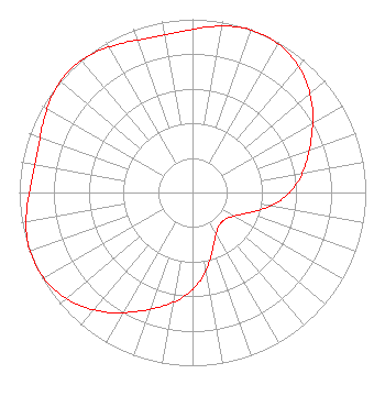 | ||||||||||||||||||||||
| Azimuth | Ratio | Azimuth | Ratio | Azimuth | Ratio | Azimuth | Ratio | ||||||||||||||||
| 5 | 0.959 | 15 | 0.990 | 25 | 0.997 | 35 | 0.975 | ||||||||||||||||
| 45 | 0.922 | 55 | 0.845 | 65 | 0.758 | 75 | 0.680 | ||||||||||||||||
| 85 | 0.605 | 95 | 0.510 | 105 | 0.397 | 115 | 0.302 | ||||||||||||||||
| 125 | 0.253 | 135 | 0.241 | 145 | 0.253 | 155 | 0.302 | ||||||||||||||||
| 165 | 0.397 | 175 | 0.510 | 185 | 0.605 | 195 | 0.680 | ||||||||||||||||
| 205 | 0.758 | 215 | 0.845 | 225 | 0.922 | 235 | 0.975 | ||||||||||||||||
| 245 | 0.997 | 255 | 0.990 | 265 | 0.959 | 275 | 0.929 | ||||||||||||||||
| 285 | 0.925 | 295 | 0.951 | 305 | 0.985 | 315 | 1.000 | ||||||||||||||||
| 325 | 0.985 | 335 | 0.951 | 345 | 0.925 | 355 | 0.929 | ||||||||||||||||
Structure Registration Number 1211048 Structure Type: GTOWER Registered To: American Towers LLC Structure Address: 1603 Se 22nd Street (373723) Oklahoma City, OK County Name: Oklahoma County ASR Issued: 01/26/2024 Date Built: 02/14/2000 Site Elevation: 382.2 m (1254 ft.) Structure Height: 122.8 m (403 ft.) Height Overall: 128 m (420 ft.) Overall Height AMSL: 510.2 m (1674 ft.) FAA Determination: 02/07/2023 FAA Study #: 2022-ASW-7467-OE FAA Circular #: 70/7460-1J Paint & Light FAA Chapters: 4, 8, 13 OM&L to remain the same as prior study = A MED-DUAL SYSTEM 35-26-35.2 N 97-28-57.2 W (NAD 83) 35-26-35.0 N 97-28-56.1 W (Converted to NAD 27) |
Chattanooga, TN 37401 Phone: 423-468-5100 Limited Liability Company | Title: Coo Date: 04/11/2023 Application Certifier Digital Networks-midwest, Llc Chattanooga, TN 37401 Applicant Timothy Z Sawyer T Z Sawyer Technical Consultants 2130 Hutchison Grove Court Suite 100 Falls Church, VA 22043 Technical Consultant Aaron P Shainis, Esq Shainis & Peltzman Chartered 1850 M Street Nw Suite 240 Washington, DC 20036 Legal Counsel | |||||||||||||||||||||