
FCCInfo.com
A Service of Cavell, Mertz & Associates, Inc.
(855) FCC-INFO
|
|
|
Post-repack Channel 29 Virtual Channel 14 |
|
|||||||||||||||||
|
|
Repacking Information: Pre-Repack Channel: 28 Post-Repack Channel: 29 Post-Repack ERP: 408 kW Phase: 6 Completion Deadline: 10/18/2019 Upstream/Downstream Dependencies Other Linked Stations Find nearby TV Facilities Status: License Application Accepted: 04/19/2023 License Expires: 10/01/2029 File Number: -0000214011 FCC Website Links: LMS Facility Details This Application Other WPTO Applications Including Superseded Applications Mailing Address Correspondence for WPTO Correspondence related to application -0000214011 Service Contour - Open Street Map or USGS Map (41 dBu) Service Contour - KML / Google Earth (41 dBu) Public Inspection Files History Cards for WPTO Rabbit Ears Info Search for WPTO Site Location: 39-07-27.0 N 84-31-18.0 W (NAD 83) Site Location: 39-07-26.8 N 84-31-18.2 W (Converted to NAD 27) ERP: 500 kW Polarization: Elliptically polarized HAAT: 279 m (915 ft.) Electrical Beam Tilt: 1 degree R/C AGL: 235 m (771 ft.) R/C AMSL: 490.4 m (1609 ft.) Site Elevation: 255.4 m. (838 ft.) Height Overall*: 289.6 m (950 ft.) (* As Filed In This Application, may differ from ASR Data, Below.) Directional Antenna - Antenna Make/Model: DIELECTRIC TFU-24DSB/VP-H (C) Antenna ID: 1010644 Polarization: Elliptically polarized | |||||||||||||||||||
| Antenna Data for Antenna Id: 1010644 WPTO DT File: -0000214011 DIELECTRIC - TFU-24DSB/VP-H (C) Service: DT Standard Pattern: N | 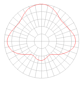 | |||||||||||||||||||
| Azimuth | Ratio | Azimuth | Ratio | Azimuth | Ratio | Azimuth | Ratio | |||||||||||||
| 0 | 1.000 | 10 | 0.977 | 20 | 0.917 | 30 | 0.842 | |||||||||||||
| 40 | 0.776 | 50 | 0.768 | 60 | 0.779 | 70 | 0.828 | |||||||||||||
| 80 | 0.885 | 90 | 0.911 | 100 | 0.880 | 110 | 0.788 | |||||||||||||
| 120 | 0.673 | 130 | 0.560 | 140 | 0.467 | 150 | 0.430 | |||||||||||||
| 160 | 0.452 | 170 | 0.495 | 180 | 0.521 | 190 | 0.511 | |||||||||||||
| 200 | 0.477 | 210 | 0.446 | 220 | 0.468 | 230 | 0.560 | |||||||||||||
| 240 | 0.688 | 250 | 0.810 | 260 | 0.891 | 270 | 0.918 | |||||||||||||
| 280 | 0.885 | 290 | 0.834 | 300 | 0.793 | 310 | 0.777 | |||||||||||||
| 320 | 0.816 | 330 | 0.885 | 340 | 0.949 | 350 | 0.984 | |||||||||||||
Structure Registration Number 1038226 Structure Type: LTOWER Registered To: Ohio/Oklahoma Hearst Television Inc. Structure Address: 2222 Chickasaw St Cincinnati, OH County Name: Hamilton County ASR Issued: 08/26/2020 Date Built: 10/03/2020 Site Elevation: 255.4 m (838 ft.) Structure Height: 273.1 m (896 ft.) Height Overall: 289.6 m (950 ft.) Overall Height AMSL: 545 m (1788 ft.) FAA Determination: 08/13/2020 FAA Study #: 2020-AGL-16564-OE FAA Circular #: 70/7460-1L Paint & Light FAA Chapters: 4, 9, 12 PRIOR STUDY 1997-AGL-5874-OE 39-07-27.0 N 84-31-18.0 W (NAD 83) 39-07-26.8 N 84-31-18.2 W (Converted to NAD 27) |
1223 Central Parkway Cincinnati, OH 45214 Phone: 513-345-6538 Not-for-Profit | Title: Cfo And Coo Date: 04/19/2023 Application Certifier Greater Cincinnati Televison Educational Foundation 1223 Central Parkway Cincinnati, OH 45214 Applicant Derek Teslik Gray Miller Persh Llp 2233 Wisconsin Avenue, Nw Ste. 226 Washington, DC 20007 Lee Weinel Greater Dayton Public Television, Inc. 110 S Jefferson St Dayton, OH 45402 Chief Financial Officer | ||||||||||||||||||
