
FCCInfo.com
A Service of Cavell, Mertz & Associates, Inc.
(855) FCC-INFO
|
|
KABI-LD from 08/14/2015 KABI-LD from 05/17/1999 |
|
|
|||||||||||||||||
|
|
Status: STA – Special Temporary Authority Application Accepted: 05/02/2023 STA Expires: 11/03/2023 File Number: -0000214432 FCC Website Links: LMS Facility Details This Application Other KABI-LD Applications Including Superseded Applications Mailing Address Correspondence for KABI-LD Correspondence related to application -0000214432 Service Contour - Open Street Map or USGS Map (51 dBu) Service Contour - KML / Google Earth (51 dBu) Rabbit Ears Info Search for KABI-LD Site Location: 32-45-34.0 N 100-54-47.0 W (NAD 83) Site Location: 32-45-33.6 N 100-54-45.6 W (Converted to NAD 27) ERP: 0.66 kW Polarization: Horizontally polarized Electrical Beam Tilt: .75 degrees R/C AGL: 79 m (259 ft.) R/C AMSL: 821.2 m (2694 ft.) Emission Mask: Stringent Site Elevation: 742.2 m. (2435 ft.) Height Overall*: 97.5 m (320 ft.) (* As Filed In This Application, may differ from ASR Data, Below.) Directional Antenna - Antenna Make/Model: R.F. Systems RD8-SK Antenna ID: 1010666 Polarization: Horizontally polarized
| |||||||||||||||||||
| Antenna Data for Antenna Id: 1010666 KABI-LD LD File: -0000214432 R.F. Systems - RD8-SK Service: LD Standard Pattern: N Pattern and Field Values Include a 184° Clockwise Rotation | 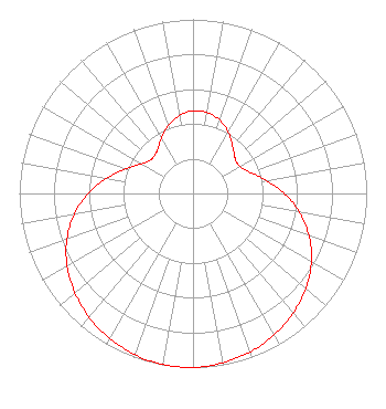 | |||||||||||||||||||
| Azimuth | Ratio | Azimuth | Ratio | Azimuth | Ratio | Azimuth | Ratio | |||||||||||||
| 4 | 0.476 | 14 | 0.465 | 24 | 0.433 | 34 | 0.386 | |||||||||||||
| 44 | 0.337 | 54 | 0.309 | 64 | 0.322 | 74 | 0.380 | |||||||||||||
| 84 | 0.467 | 94 | 0.565 | 104 | 0.659 | 114 | 0.743 | |||||||||||||
| 124 | 0.813 | 134 | 0.868 | 144 | 0.914 | 154 | 0.950 | |||||||||||||
| 164 | 0.976 | 174 | 0.994 | 184 | 1.000 | 194 | 0.994 | |||||||||||||
| 204 | 0.976 | 214 | 0.950 | 224 | 0.914 | 234 | 0.868 | |||||||||||||
| 244 | 0.813 | 254 | 0.743 | 264 | 0.659 | 274 | 0.565 | |||||||||||||
| 284 | 0.467 | 294 | 0.380 | 304 | 0.322 | 314 | 0.309 | |||||||||||||
| 324 | 0.337 | 334 | 0.386 | 344 | 0.433 | 354 | 0.465 | |||||||||||||
Structure Registration Number 1056573 Structure Type: TOWER Registered To: SNYDER BROADCASTING Structure Address: 1.1 Mi E Of Us-84, 0.25 Mi E Of Sr-208; In The City Limit Of Snyder, TX County Name: Scurry County ASR Issued: 09/28/1998 Site Elevation: 742.2 m (2435 ft.) Structure Height: 91.4 m (300 ft.) Height Overall: 97.5 m (320 ft.) Overall Height AMSL: 839.7 m (2755 ft.) FAA Determination: 08/19/1998 FAA Study #: 98-ASW-3077-OE FAA Circular #: Paint & Light FAA Chapters: 1, 3, 11, 21 OM&L TO REMAIN PAINT/RED LIGHTS AS PER PREV. 95-ASW-0655-OE. 32-45-34.0 N 100-54-47.0 W (NAD 83) 32-45-33.6 N 100-54-45.6 W (Converted to NAD 27) |
4370 Peachtree Road, Ne Atlanta, GA 30319 Phone: 404-504-9828 Limited Liability Company | Title: Assistant Secretary Date: 05/02/2023 Application Certifier Gray Television Licensee, Llc 4370 Peachtree Road, Ne Atlanta, GA 30319 Applicant Joan Stewart Wiley Rein Llp 2050 M Street, Nw Washington, DC 20006 | ||||||||||||||||||