
FCCInfo.com
A Service of Cavell, Mertz & Associates, Inc.
(855) FCC-INFO
|
|
WIDO-LD from 09/28/2010 |
|
|
|||||||||||||||||
|
|
Status: STA – Special Temporary Authority (Licensed And Silent) Application Accepted: 06/06/2023 STA Expires: 12/01/2023 File Number: -0000216275 FCC Website Links: LMS Facility Details This Application Other WIDO-LD Applications Including Superseded Applications Mailing Address Correspondence for WIDO-LD Correspondence related to application -0000216275 Service Contour - Open Street Map or USGS Map (51 dBu) Service Contour - KML / Google Earth (51 dBu) Rabbit Ears Info Search for WIDO-LD Site Location: 34-07-54.0 N 78-11-16.0 W (NAD 83) Site Location: 34-07-53.4 N 78-11-17.0 W (Converted to NAD 27) ERP: 0.2 kW Polarization: Horizontally polarized R/C AGL: 11 m (36 ft.) R/C AMSL: 30.2 m (99 ft.) Emission Mask: Stringent Site Elevation: 19.2 m. (63 ft.) Height Overall*: 595.6 m (1954 ft.) (* As Filed In This Application, may differ from ASR Data, Below.) Directional Antenna - Antenna Make/Model: ELTI ELTI UHF Panel Antenna ID: 1008435 Polarization: Horizontally polarized
| |||||||||||||||||||
| Antenna Data for Antenna Id: 1008435 WIDO-LD LD File: -0000216275 ELTI - ELTI UHF Panel Service: LD Standard Pattern: Y Pattern and Field Values Include a 90° Clockwise Rotation | 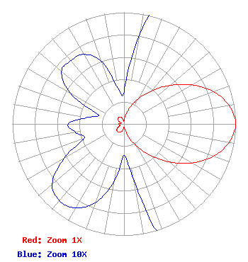 | |||||||||||||||||||
| Azimuth | Ratio | Azimuth | Ratio | Azimuth | Ratio | Azimuth | Ratio | |||||||||||||
| 0 | 0.029 | 10 | 0.082 | 20 | 0.158 | 30 | 0.263 | |||||||||||||
| 40 | 0.389 | 50 | 0.537 | 60 | 0.700 | 70 | 0.851 | |||||||||||||
| 80 | 0.955 | 90 | 1.000 | 100 | 0.955 | 110 | 0.851 | |||||||||||||
| 120 | 0.700 | 130 | 0.531 | 140 | 0.367 | 150 | 0.232 | |||||||||||||
| 160 | 0.132 | 170 | 0.052 | 180 | 0.028 | 190 | 0.053 | |||||||||||||
| 200 | 0.075 | 210 | 0.087 | 220 | 0.090 | 230 | 0.084 | |||||||||||||
| 240 | 0.062 | 250 | 0.038 | 260 | 0.044 | 270 | 0.050 | |||||||||||||
| 280 | 0.033 | 290 | 0.025 | 300 | 0.056 | 310 | 0.073 | |||||||||||||
| 320 | 0.074 | 330 | 0.072 | 340 | 0.060 | 350 | 0.033 | |||||||||||||
Structure Registration Number 1008242 Structure Type: GTOWER Registered To: Brunswick County Tower, LLC Structure Address: 4.7 Km Ssw Of Int Of Sr 1410 & Sr 1413 Winnabow, NC County Name: Brunswick County ASR Issued: 05/13/2015 Date Built: 06/17/1981 Site Elevation: 19.2 m (63 ft.) Structure Height: 548 m (1798 ft.) Height Overall: 595.6 m (1954 ft.) Overall Height AMSL: 614.8 m (2017 ft.) FAA Determination: 12/06/2002 FAA Study #: 2002-ASO-6761-OE FAA Circular #: 70/7460-1 Paint & Light FAA Chapters: A1, B, G, H PRIOR STUDY 1996-ASO-2598-OE OM&L TO REMAIN 24 HR HI STROBES PER PRIOR STUDY 34-07-54.0 N 78-11-16.0 W (NAD 83) 34-07-53.4 N 78-11-17.0 W (Converted to NAD 27) |
14 Tuxedo Drive Beaufort, SC 29907 Phone: 717-226-3535 Limited Liability Company | Title: Managing Member Date: 06/06/2023 Application Certifier Lowcountry 34 Media, Llc 14 Tuxedo Drive Beaufort, SC 29907 Applicant Davina Sashkin, Esq Wilkinson Barker Knauer, Llp 1800 M Street, Nw Suite 800n Washington, DC 20036 | ||||||||||||||||||