
FCCInfo.com
A Service of Cavell, Mertz & Associates, Inc.
(855) FCC-INFO
|
|
K43LK-D from 07/21/2009 K43LK-D from 08/05/2008 K43LK-D from 09/21/2005 |
|
|
||||||||||||||||
|
|
Status: License Application Accepted: 08/01/2023 License Expires: 06/01/2022 File Number: -0000218713 FCC Website Links: LMS Facility Details This Application Other K34NE-D Applications Including Superseded Applications Mailing Address Correspondence for K34NE-D Correspondence related to application -0000218713 Service Contour - Open Street Map or USGS Map (51 dBu) Service Contour - KML / Google Earth (51 dBu) Rabbit Ears Info Search for K34NE-D Site Location: 34-36-27.0 N 98-16-27.0 W (NAD 83) Site Location: 34-36-26.7 N 98-16-25.8 W (Converted to NAD 27) ERP: 2.5 kW Polarization: Elliptically polarized R/C AGL: 151 m (495 ft.) R/C AMSL: 526 m (1726 ft.) Emission Mask: Stringent Site Elevation: 375 m. (1230 ft.) Height Overall*: 152 m (499 ft.) (* As Filed In This Application, may differ from ASR Data, Below.) Directional Antenna - Antenna Make/Model: Kathrein 1x1 UVTC-01/X/R Antenna ID: 1009961 Polarization: Elliptically polarized | ||||||||||||||||||
| Antenna Data for Antenna Id: 1009961 K34NE-D LD File: -0000218713 Kathrein - 1x1 UVTC-01/X/R Service: LD Standard Pattern: N | 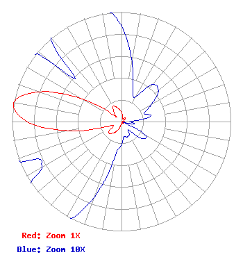 | ||||||||||||||||||
| Azimuth | Ratio | Azimuth | Ratio | Azimuth | Ratio | Azimuth | Ratio | ||||||||||||
| 0 | 0.087 | 10 | 0.055 | 20 | 0.030 | 30 | 0.026 | ||||||||||||
| 40 | 0.044 | 50 | 0.044 | 60 | 0.032 | 70 | 0.022 | ||||||||||||
| 80 | 0.027 | 90 | 0.008 | 100 | 0.012 | 110 | 0.002 | ||||||||||||
| 120 | 0.025 | 130 | 0.024 | 140 | 0.010 | 150 | 0.014 | ||||||||||||
| 160 | 0.015 | 170 | 0.014 | 180 | 0.021 | 190 | 0.032 | ||||||||||||
| 200 | 0.074 | 210 | 0.110 | 220 | 0.141 | 230 | 0.152 | ||||||||||||
| 240 | 0.084 | 250 | 0.132 | 260 | 0.487 | 270 | 0.860 | ||||||||||||
| 280 | 1.000 | 290 | 0.795 | 300 | 0.415 | 310 | 0.081 | ||||||||||||
| 320 | 0.102 | 330 | 0.156 | 340 | 0.142 | 350 | 0.112 | ||||||||||||
Structure Registration Number 1011804 Structure Type: TOWER Registered To: PATRICK, ARTHUR DBA = LAWTON COMMUNICATIONS Structure Address: 7 Mi E Hwy 7 To Trail Ridge Rd N 1 Mi W 2950' Lawton, OK County Name: Comanche County ASR Issued: 01/13/1997 Date Built: 07/01/1983 Site Elevation: 375 m (1230 ft.) Structure Height: 146 m (479 ft.) Height Overall: 152 m (499 ft.) Overall Height AMSL: 527 m (1729 ft.) FAA Determination: 03/30/1983 FAA Study #: 83-ASW-0459-OE FAA Circular #: 70/7460-1F Paint & Light FAA Chapters: 3, 4, 5, 9 34-36-27.0 N 98-16-27.0 W (NAD 83) 34-36-26.7 N 98-16-25.8 W (Converted to NAD 27) |
Hurst, TX 76054 Phone: 214-770-7770 Corporation | Title: Ceo Date: 08/01/2023 Application Certifier EDGE SPECTRUM, INC. Edge Spectrum, Inc. Hurst, TX 76054 Applicant Susan Hansen B. W. St. Clair 2305 Vida Shaw Rd. New Iberia, LA 70563 Consultant Ari Meltzer Wiley Rein Llp 2050 M St Nw Washington, DC 20036 Caleb Weiss Ark Multicasting, Inc. Cedar Hill, TX 75106 President Randy Weiss Edge Spectrum, Inc. Hurst, TX 76054 CEO Josh Weiss Ark Multicasting, Inc. Cedar Hill, TX 75106 CEO | |||||||||||||||||