
FCCInfo.com
A Service of Cavell, Mertz & Associates, Inc.
(855) FCC-INFO
|
|
KQDK-CD from 06/17/2008 KQDK-CD from 02/18/2000 KQDK-CD from 11/22/1999 KQDK-CD from 11/15/1999 |
Post-repack Channel 16 |  |
|
|||||||||||||||
|
|
Repacking Information: Pre-Repack Channel: 39 Post-Repack Channel: 16 Post-Repack ERP: 0.605 kW Phase: 2 Completion Deadline: 4/12/2019 Find nearby TV Facilities Status: Construction Permit Application Accepted: 08/28/2023 KQDK-CD CP Expires: 08/30/2026 File Number: -0000219959 FCC Website Links: LMS Facility Details This Application Other KQDK-CD Applications Including Superseded Applications Mailing Address Correspondence for KQDK-CD Correspondence related to application -0000219959 Service Contour - Open Street Map or USGS Map (51 dBu) Service Contour - KML / Google Earth (51 dBu) Public Inspection Files Rabbit Ears Info Search for KQDK-CD Site Location: 39-43-44.1 N 105-14-10.0 W (NAD 83) Site Location: 39-43-44.1 N 105-14-08.0 W (Converted to NAD 27) ERP: 15 kW Polarization: Horizontally polarized Electrical Beam Tilt: 1.5 degrees R/C AGL: 27.4 m (90 ft.) R/C AMSL: 2267.1 m (7438 ft.) Emission Mask: Full Service Site Elevation: 2239.7 m. (7348 ft.) Height Overall*: 49 m (161 ft.) (* As Filed In This Application, may differ from ASR Data, Below.) Directional Antenna - Antenna Make/Model: Dielectric TUL-C2-04/08M-T Antenna ID: 1011041 Polarization: Horizontally polarized | ||||||||||||||||||
| Antenna Data for Antenna Id: 1011041 KQDK-CD DC File: -0000219959 Dielectric - TUL-C2-04/08M-T Service: DC Standard Pattern: N Pattern and Field Values Include a 138° Clockwise Rotation | 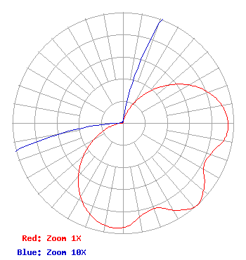 | ||||||||||||||||||
| Azimuth | Ratio | Azimuth | Ratio | Azimuth | Ratio | Azimuth | Ratio | ||||||||||||
| 8 | 0.010 | 18 | 0.077 | 28 | 0.192 | 38 | 0.339 | ||||||||||||
| 48 | 0.500 | 58 | 0.657 | 68 | 0.793 | 78 | 0.893 | ||||||||||||
| 88 | 0.946 | 98 | 0.936 | 108 | 0.849 | 118 | 0.827 | ||||||||||||
| 128 | 0.931 | 138 | 1.000 | 148 | 0.931 | 158 | 0.827 | ||||||||||||
| 168 | 0.849 | 178 | 0.936 | 188 | 0.946 | 198 | 0.893 | ||||||||||||
| 208 | 0.793 | 218 | 0.657 | 228 | 0.500 | 238 | 0.339 | ||||||||||||
| 248 | 0.192 | 258 | 0.077 | 268 | 0.010 | 278 | 0.001 | ||||||||||||
| 288 | 0.001 | 298 | 0.001 | 308 | 0.001 | 318 | 0.001 | ||||||||||||
| 328 | 0.001 | 338 | 0.001 | 348 | 0.001 | 358 | 0.001 | ||||||||||||
Structure Registration Number 1023423 Structure Type: GTOWER Registered To: VB-S1 Assets, LLC Structure Address: On Lookout Mountain 3.2 Km Sw Golden, CO County Name: Jefferson County ASR Issued: 04/01/2022 Date Built: 01/01/1973 Site Elevation: 2239.7 m (7348 ft.) Structure Height: 49 m (161 ft.) Height Overall: 49 m (161 ft.) Overall Height AMSL: 2288.7 m (7509 ft.) FAA Determination: 04/02/2015 FAA Study #: 2015-ANM-299-OE Paint & Light FAA Chapters: NONE 39-43-44.1 N 105-14-10.0 W (NAD 83) 39-43-44.1 N 105-14-08.0 W (Converted to NAD 27) |
Clearwater, FL 33758 Phone: 727-535-5622 Not-for-Profit | Title: President Date: 08/28/2023 Application Certifier Christian Television Network Christian Television Corporation, Inc. Clearwater, FL 33758 Applicant Louis R duTreil, Jr Dutreil Lundin & Rackley Inc P.o. Box 161 Osprey, FL 34229 Technical Consultant Joseph C Chautin, III Hardy, Carey, Chautin & Balkin, Llp 1080 West Causeway Approach Mandeville, LA 70471 Attorney | |||||||||||||||||