
FCCInfo.com
A Service of Cavell, Mertz & Associates, Inc.
(855) FCC-INFO
|
|
W31EJ-D from 05/24/2011 W31EJ-D from 09/28/2010 |
|
|
||||||||||||||||
|
|
Status: License Application Accepted: 09/05/2023 License Expires: 02/01/2029 File Number: -0000220416 FCC Website Links: LMS Facility Details This Application Other W31EJ-D Applications Including Superseded Applications Mailing Address Correspondence for W31EJ-D Correspondence related to application -0000220416 Service Contour - Open Street Map or USGS Map (51 dBu) Service Contour - KML / Google Earth (51 dBu) Rabbit Ears Info Search for W31EJ-D Site Location: 18-21-27.8 N 64-58-17.4 W (NAD 83) Site Location: 18-21-35.0 N 64-58-18.9 W (Converted to NAD 27) ERP: 3 kW Polarization: Horizontally polarized R/C AGL: 14 m (46 ft.) R/C AMSL: 454 m (1490 ft.) Emission Mask: Simple Site Elevation: 440 m. (1444 ft.) Height Overall*: 75 m (246 ft.) (* As Filed In This Application, may differ from ASR Data, Below.) Directional Antenna - Antenna Make/Model: Kathrein 75010210 Antenna ID: 1003083 Polarization: Horizontally polarized
| ||||||||||||||||||
| Antenna Data for Antenna Id: 1003083 W31EJ-D LD File: -0000220416 Kathrein - 75010210 Service: LD Standard Pattern: Y Pattern and Field Values Include a 110° Clockwise Rotation | 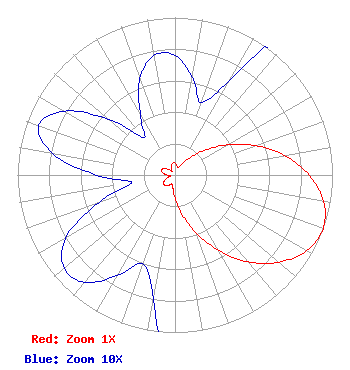 | ||||||||||||||||||
| Azimuth | Ratio | Azimuth | Ratio | Azimuth | Ratio | Azimuth | Ratio | ||||||||||||
| 0 | 0.076 | 10 | 0.063 | 20 | 0.049 | 30 | 0.070 | ||||||||||||
| 40 | 0.139 | 50 | 0.242 | 60 | 0.384 | 70 | 0.543 | ||||||||||||
| 80 | 0.708 | 90 | 0.851 | 100 | 0.958 | 110 | 1.000 | ||||||||||||
| 120 | 0.964 | 130 | 0.861 | 140 | 0.721 | 150 | 0.553 | ||||||||||||
| 160 | 0.392 | 170 | 0.253 | 180 | 0.147 | 190 | 0.080 | ||||||||||||
| 200 | 0.060 | 210 | 0.074 | 220 | 0.089 | 230 | 0.092 | ||||||||||||
| 240 | 0.080 | 250 | 0.052 | 260 | 0.028 | 270 | 0.050 | ||||||||||||
| 280 | 0.079 | 290 | 0.092 | 300 | 0.081 | 310 | 0.055 | ||||||||||||
| 320 | 0.031 | 330 | 0.044 | 340 | 0.065 | 350 | 0.077 | ||||||||||||
Structure Registration Number 1238843 Structure Type: TOWER Registered To: Crown Kinder LLC Structure Address: Crown Mountain Charlotte Amalie, VI County Name: St. Thomas Island ASR Issued: 05/13/2003 Site Elevation: 440 m (1444 ft.) Structure Height: 75 m (246 ft.) Height Overall: 75 m (246 ft.) Overall Height AMSL: 515 m (1690 ft.) FAA Determination: 04/01/2003 FAA Study #: 2002-ASO-5614-OE FAA Circular #: 70/7460-1K Paint & Light FAA Chapters: 4, 8, 12 Removed expiration date from determination. Scenario 1./jjs/case#635066 18-21-27.8 N 64-58-17.4 W (NAD 83) 18-21-35.0 N 64-58-18.9 W (Converted to NAD 27) |
Po Box 903 Saint Just, PR 00978 Phone: 787-761-2833 Corporation | Title: President Date: 09/05/2023 Application Certifier TV RED DE PUERTO RICO INC Tv Red De Puerto Rico Inc Po Box 903 Saint Just, PR 00978 Applicant JORGE R FIGUEROA Tv Red De Puerto Rico Inc Po Box 903 Saint Just, PR 00978 GRAFTON OLIVERA Grafton Olivera, P.e. Consulting Engineer 5119 60th Drive E Bradenton, FL 34203 TECHNICAL CONSULTANT | |||||||||||||||||