
FCCInfo.com
A Service of Cavell, Mertz & Associates, Inc.
(855) FCC-INFO
|
|
WFTY-DT from 01/01/2004 WFTY-DT from 11/01/2001 WFTY-DT from 12/29/1992 WFTY-DT from 01/23/1987 WFTY-DT from 01/10/1979 |
Virtual Channel 67 |
|
|||||||||||||||||||
|
|
Repacking Information: No changes Status: License Application Accepted: 09/25/2023 License Expires: 06/01/2023 File Number: -0000221435 FCC Website Links: LMS Facility Details This Application Other WFTY-DT Applications Including Superseded Applications Mailing Address Correspondence for WFTY-DT Correspondence related to application -0000221435 Service Contour - Open Street Map or USGS Map (41 dBu) Service Contour - KML / Google Earth (41 dBu) Public Inspection Files Rabbit Ears Info Search for WFTY-DT Site Location: 40-53-23.0 N 72-57-11.0 W (NAD 83) Site Location: 40-53-22.6 N 72-57-12.6 W (Converted to NAD 27) ERP: 82 kW Polarization: Elliptically polarized HAAT: 203.7 m (668 ft.) Electrical Beam Tilt: 0.75 degrees R/C AGL: 185.6 m (609 ft.) R/C AMSL: 228.6 m (750 ft.) Site Elevation: 43 m. (141 ft.) Height Overall*: 207.6 m (681 ft.) (* As Filed In This Application, may differ from ASR Data, Below.) Directional Antenna - Antenna Make/Model: Andrew ATW22H3-ESP5-23H Antenna ID: 1011114 Polarization: Elliptically polarized | |||||||||||||||||||||
| Antenna Data for Antenna Id: 1011114 WFTY-DT DX File: -0000221435 Andrew - ATW22H3-ESP5-23H Service: DX Standard Pattern: N | 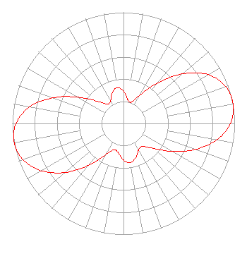 | |||||||||||||||||||||
| Azimuth | Ratio | Azimuth | Ratio | Azimuth | Ratio | Azimuth | Ratio | |||||||||||||||
| 0 | 0.290 | 10 | 0.219 | 20 | 0.203 | 30 | 0.296 | |||||||||||||||
| 40 | 0.475 | 50 | 0.693 | 60 | 0.878 | 70 | 0.976 | |||||||||||||||
| 80 | 1.000 | 90 | 0.961 | 100 | 0.851 | 110 | 0.686 | |||||||||||||||
| 120 | 0.504 | 130 | 0.350 | 140 | 0.270 | 150 | 0.273 | |||||||||||||||
| 160 | 0.325 | 170 | 0.359 | 180 | 0.329 | 190 | 0.268 | |||||||||||||||
| 200 | 0.252 | 210 | 0.329 | 220 | 0.494 | 230 | 0.687 | |||||||||||||||
| 240 | 0.851 | 250 | 0.960 | 260 | 0.999 | 270 | 0.966 | |||||||||||||||
| 280 | 0.859 | 290 | 0.675 | 300 | 0.472 | 310 | 0.315 | |||||||||||||||
| 320 | 0.229 | 330 | 0.233 | 340 | 0.294 | 350 | 0.328 | |||||||||||||||
Structure Registration Number 1007666 Structure Type: TOWER Registered To: Univision Television Group, Inc. Structure Address: 607 Middle Country Rd Middle Island, NY County Name: Suffolk County ASR Issued: 10/18/2007 Date Built: 10/04/1984 Site Elevation: 43 m (141 ft.) Structure Height: 195.2 m (640 ft.) Height Overall: 207.6 m (681 ft.) Overall Height AMSL: 250.6 m (822 ft.) FAA Determination: 09/08/2006 FAA Study #: 2006-AEA-3199-OE FAA Circular #: 70/7460-1K Paint & Light FAA Chapters: 4, 7, 12 PRIOR STUDY 1996-AEA-2255-OE 40-53-23.0 N 72-57-11.0 W (NAD 83) 40-53-22.6 N 72-57-12.6 W (Converted to NAD 27) |
101 Constitution Avenue, Nw, Suite 800w Washington, DC 20001 Phone: 310-348-3600 Limited Liability Company | Title: Senior Vice President Us Regulatory Date: 09/25/2023 Application Certifier UNIVISION NEW YORK LLC Univision New York Llc 101 Constitution Avenue, Nw, Suite 800w Washington, DC 20001 Applicant MATTHEW S. DELNERO Covington & Burling Llp One Citycenter 850 Tenth Street, Nw Washington, DC 20001 Joseph L Seccia, P.E. Televisaunivision 9405 Nw 41st St Miami, FL 33178 Regional Director, RF Transmission | ||||||||||||||||||||
| ||||||||||||||||||||||