
FCCInfo.com
A Service of Cavell, Mertz & Associates, Inc.
(855) FCC-INFO
|
|
WMFD-TV from 07/24/1987 WMFD-TV from 01/10/1986 |
Virtual Channel 68 |  |
|
|||||||||||||||
|
|
Repacking Information: No changes Status: License Application Accepted: 10/04/2023 License Expires: 10/01/2029 File Number: -0000222027 FCC Website Links: LMS Facility Details This Application Other WMFD-TV Applications Including Superseded Applications Mailing Address Correspondence for WMFD-TV Correspondence related to application -0000222027 Service Contour - Open Street Map or USGS Map (36 dBu) Service Contour - KML / Google Earth (36 dBu) Public Inspection Files Rabbit Ears Info Search for WMFD-TV Site Location: 40-45-50.0 N 82-37-04.0 W (NAD 83) Site Location: 40-45-49.8 N 82-37-04.4 W (Converted to NAD 27) ERP: 16.4 kW Polarization: Horizontally polarized HAAT: 180 m (591 ft.) R/C AGL: 137 m (449 ft.) R/C AMSL: 557.6 m (1829 ft.) Site Elevation: 420.6 m. (1380 ft.) Height Overall*: 143.9 m (472 ft.) (* As Filed In This Application, may differ from ASR Data, Below.) Directional Antenna - Antenna Make/Model: KATHREIN K52 34 527 Panel Antenna ID: 1011146 Polarization: Horizontally polarized | ||||||||||||||||||
| Antenna Data for Antenna Id: 1011146 WMFD-TV DT File: -0000222027 KATHREIN - K52 34 527 Panel Service: DT Standard Pattern: N | 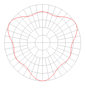 | ||||||||||||||||||
| Azimuth | Ratio | Azimuth | Ratio | Azimuth | Ratio | Azimuth | Ratio | ||||||||||||
| 0 | 0.806 | 10 | 0.788 | 20 | 0.761 | 30 | 0.785 | ||||||||||||
| 40 | 0.872 | 50 | 0.961 | 60 | 1.000 | 70 | 0.961 | ||||||||||||
| 80 | 0.871 | 90 | 0.785 | 100 | 0.761 | 110 | 0.788 | ||||||||||||
| 120 | 0.806 | 130 | 0.788 | 140 | 0.761 | 150 | 0.785 | ||||||||||||
| 160 | 0.871 | 170 | 0.961 | 180 | 1.000 | 190 | 0.961 | ||||||||||||
| 200 | 0.872 | 210 | 0.785 | 220 | 0.761 | 230 | 0.788 | ||||||||||||
| 240 | 0.806 | 250 | 0.789 | 260 | 0.761 | 270 | 0.785 | ||||||||||||
| 280 | 0.872 | 290 | 0.961 | 300 | 1.000 | 310 | 0.961 | ||||||||||||
| 320 | 0.872 | 330 | 0.785 | 340 | 0.761 | 350 | 0.789 | ||||||||||||
Structure Registration Number 1013230 Structure Type: GTOWER Registered To: MID STATE TELEVISION INC Structure Address: 2900 Park Ave W Ontario, OH County Name: Richland County ASR Issued: 12/13/2012 Date Built: 02/15/2013 Site Elevation: 420.6 m (1380 ft.) Structure Height: 143.9 m (472 ft.) Height Overall: 143.9 m (472 ft.) Overall Height AMSL: 564.5 m (1852 ft.) FAA Determination: 12/10/2012 FAA Study #: 2012-AGL-10203-OE FAA Circular #: 70/7460-1G Paint & Light FAA Chapters: 3, 4, 5, 9 PRIOR STUDY 1989-AGL-379-OE CHAPTERS 3,4,5,9 (1G) ADD SPECIAL CONDITION FOR LIGHTING DEVIATION. 40-45-50.0 N 82-37-04.0 W (NAD 83) 40-45-49.8 N 82-37-04.4 W (Converted to NAD 27) |
2900 Park Avenue West Mansfield, OH 44906 Phone: 419-529-5900 Corporation | Title: President Date: 10/04/2023 Application Certifier MID-STATE TELEVISION, INC. Mid-state Television, Inc. 2900 Park Avenue West Mansfield, OH 44906 Applicant Anne Goodwin Crump Fletcher, Heald & Hildreth, P.l.c. 1300 N. 17th Street Eleventh Floor Arlington, VA 22209 | |||||||||||||||||
| |||||||||||||||||||