
FCCInfo.com
A Service of Cavell, Mertz & Associates, Inc.
(855) FCC-INFO
|
|
W31FE-D from 06/10/2020 W31FE-D from 09/19/2001 |
|
|
|||||||||||||||||
|
|
Status: Construction Permit Application Accepted: 10/06/2023 W31FE-D CP Expires: 05/06/2025 File Number: -0000222213 FCC Website Links: LMS Facility Details This Application Other W31FE-D Applications Including Superseded Applications Mailing Address Correspondence for W31FE-D Correspondence related to application -0000222213 Service Contour - Open Street Map or USGS Map (51 dBu) Service Contour - KML / Google Earth (51 dBu) Rabbit Ears Info Search for W31FE-D Site Location: 31-57-03.4 N 81-19-10.1 W (NAD 83) Site Location: 31-57-02.6 N 81-19-10.7 W (Converted to NAD 27) ERP: 15 kW Polarization: Horizontally polarized Electrical Beam Tilt: 0.75 degrees R/C AGL: 85 m (279 ft.) R/C AMSL: 88.9 m (292 ft.) Emission Mask: Full Service Site Elevation: 3.9 m. (13 ft.) Height Overall*: 93.8 m (308 ft.) (* As Filed In This Application, may differ from ASR Data, Below.) Directional Antenna - Antenna Make/Model: Propagation System Inc PSILP12OI Antenna ID: 1011157 Polarization: Horizontally polarized
| |||||||||||||||||||
| Antenna Data for Antenna Id: 1011157 W31FE-D LD File: -0000222213 Propagation System Inc - PSILP12OI Service: LD Standard Pattern: N Pattern and Field Values Include a 198.0° Clockwise Rotation | 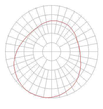 | |||||||||||||||||||
| Azimuth | Ratio | Azimuth | Ratio | Azimuth | Ratio | Azimuth | Ratio | |||||||||||||
| 8 | 0.670 | 18 | 0.670 | 28 | 0.670 | 38 | 0.660 | |||||||||||||
| 48 | 0.640 | 58 | 0.620 | 68 | 0.600 | 78 | 0.600 | |||||||||||||
| 88 | 0.610 | 98 | 0.630 | 108 | 0.660 | 118 | 0.710 | |||||||||||||
| 128 | 0.760 | 138 | 0.820 | 148 | 0.870 | 158 | 0.910 | |||||||||||||
| 168 | 0.950 | 178 | 0.980 | 188 | 1.000 | 198 | 1.000 | |||||||||||||
| 208 | 1.000 | 218 | 0.980 | 228 | 0.950 | 238 | 0.910 | |||||||||||||
| 248 | 0.870 | 258 | 0.820 | 268 | 0.760 | 278 | 0.710 | |||||||||||||
| 288 | 0.660 | 298 | 0.630 | 308 | 0.610 | 318 | 0.600 | |||||||||||||
| 328 | 0.600 | 338 | 0.620 | 348 | 0.640 | 358 | 0.660 | |||||||||||||
Structure Registration Number 1023937 Structure Type: GTOWER Registered To: American Towers LLC Structure Address: 9386 Ford Ave. (88521) Richmond Hill, GA County Name: Bryan County ASR Issued: 10/24/2023 Date Built: 11/03/1993 Site Elevation: 3.9 m (13 ft.) Structure Height: 88.4 m (290 ft.) Height Overall: 93.9 m (308 ft.) Overall Height AMSL: 97.8 m (321 ft.) FAA Determination: 04/30/2004 FAA Study #: 2004-ASO-1706-OE FAA Circular #: 70/7460-1K Paint & Light FAA Chapters: 4, 8, 12 PRIOR STUDY 2002-ASO-1438-OE 31-57-03.5 N 81-19-10.1 W (NAD 83) 31-57-02.7 N 81-19-10.7 W (Converted to NAD 27) |
Chattanooga, TN 37401 Phone: 423-468-5100 Limited Liability Company | Title: Coo Date: 10/06/2023 Application Certifier DIGITAL NETWORKS-SOUTHEAST, LLC Digital Networks-southeast, Llc Chattanooga, TN 37401 Applicant Timothy Z Sawyer T Z Sawyer Technical Consultants 2130 Hutchison Grove Court Suite 100 Falls Church, VA 22043 Technical Consultant Aaron P Shainis Shainis & Peltzman, Chartered 1850 M St. Nw Suite 240 Washington, DC 20036 FCC Legal Counsel | ||||||||||||||||||