
FCCInfo.com
A Service of Cavell, Mertz & Associates, Inc.
(855) FCC-INFO
|
|
WYCN-LD from 10/06/2016 WYCN-LD from 02/14/2002 WYCN-LD from 05/12/1992 |
Virtual Channel 8 |
|
|||||||||||||||||||
|
|
Status: License Application Accepted: 11/03/2023 License Expires: 04/01/2031 File Number: -0000224675 FCC Website Links: LMS Facility Details This Application Other WYCN-LD Applications Including Superseded Applications Mailing Address Correspondence for WYCN-LD Correspondence related to application -0000224675 Service Contour - Open Street Map or USGS Map (51 dBu) Service Contour - KML / Google Earth (51 dBu) Rabbit Ears Info Search for WYCN-LD Site Location: 41-59-49.4 N 71-09-14.3 W (NAD 83) Site Location: 41-59-49.0 N 71-09-16.1 W (Converted to NAD 27) ERP: 12.66 kW Polarization: Elliptically polarized Electrical Beam Tilt: 1.45 degrees R/C AGL: 56.9 m (187 ft.) R/C AMSL: 86.2 m (283 ft.) Emission Mask: Stringent Site Elevation: 29.3 m. (96 ft.) Height Overall*: 60.4 m (198 ft.) (* As Filed In This Application, may differ from ASR Data, Below.) Directional Antenna - Antenna Make/Model: Dielectric TLP-4F/VP-R Antenna ID: 1011231 Polarization: Elliptically polarized
| |||||||||||||||||||||
| Antenna Data for Antenna Id: 1011231 WYCN-LD LD File: -0000224675 Dielectric - TLP-4F/VP-R Service: LD Standard Pattern: N | 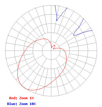 | |||||||||||||||||||||
| Azimuth | Ratio | Azimuth | Ratio | Azimuth | Ratio | Azimuth | Ratio | |||||||||||||||
| 0 | 0.137 | 10 | 0.074 | 12 | 0.071 | 20 | 0.098 | |||||||||||||||
| 30 | 0.138 | 33 | 0.141 | 40 | 0.130 | 50 | 0.078 | |||||||||||||||
| 55 | 0.060 | 60 | 0.078 | 70 | 0.161 | 80 | 0.238 | |||||||||||||||
| 90 | 0.290 | 100 | 0.323 | 110 | 0.351 | 120 | 0.385 | |||||||||||||||
| 130 | 0.426 | 140 | 0.471 | 150 | 0.517 | 160 | 0.566 | |||||||||||||||
| 170 | 0.625 | 180 | 0.706 | 190 | 0.810 | 200 | 0.915 | |||||||||||||||
| 210 | 0.986 | 216 | 1.000 | 220 | 0.995 | 230 | 0.938 | |||||||||||||||
| 240 | 0.837 | 250 | 0.728 | 260 | 0.634 | 270 | 0.563 | |||||||||||||||
| 280 | 0.505 | 290 | 0.454 | 300 | 0.406 | 310 | 0.364 | |||||||||||||||
| 320 | 0.329 | 330 | 0.300 | 340 | 0.264 | 350 | 0.211 | |||||||||||||||
Structure Registration Number 1049262 Structure Type: LTOWER Registered To: CCATT LLC Structure Address: 308 E. Main Street Norton, MA County Name: Bristol County ASR Issued: 01/30/2019 Date Built: 05/28/1998 Site Elevation: 29.3 m (96 ft.) Structure Height: 59.4 m (195 ft.) Height Overall: 60.4 m (198 ft.) Overall Height AMSL: 89.7 m (294 ft.) FAA Determination: 08/15/2018 FAA Study #: 2018-ANE-4325-OE Paint & Light FAA Chapters: NONE PRIOR STUDY 2000-ANE-103-OE 41-59-49.4 N 71-09-14.3 W (NAD 83) 41-59-49.0 N 71-09-16.1 W (Converted to NAD 27) |
300 New Jersey Avenue, Nw Suite 700 Washington, DC 20001 Phone: 202-524-6413 Limited Partnership | Title: Assistant Secretary Date: 11/03/2023 Application Certifier Station Venture Operations, Lp 300 New Jersey Avenue, Nw Suite 700 Washington, DC 20001 Applicant Angela Y. Ball Nbcuniversal, Llc 300 New Jersey Avenue, Nw Suite 700 Washington, DC 20001 Assistant Secretary H. Douglas Lung Nbcuniversal, Llc Honomu, HI 96728 Corporate Engineering Manager | ||||||||||||||||||||
| ||||||||||||||||||||||