
FCCInfo.com
A Service of Cavell, Mertz & Associates, Inc.
(855) FCC-INFO
|
|
|
Post-repack Channel 29 Virtual Channel 50 |
|
||||||||||||||||
|
|
Repacking Information: Pre-Repack Channel: 50 Post-Repack Channel: 29 Post-Repack ERP: 7.34 kW Phase: 2 Completion Deadline: 4/12/2019 Find nearby TV Facilities Status: Construction Permit Application Accepted: 12/18/2023 KKAI CP Expires: 02/21/2027 File Number: -0000232286 FCC Website Links: LMS Facility Details This Application Other KKAI Applications Including Superseded Applications Mailing Address Correspondence for KKAI Correspondence related to application -0000232286 Service Contour - Open Street Map or USGS Map (41 dBu) Service Contour - KML / Google Earth (41 dBu) Public Inspection Files Rabbit Ears Info Search for KKAI DTS Site Number: 2 Site Location: 21-24-11.8 N 158-05-52.8 W (NAD 83) Site Location: 21-24-23.2 N 158-06-02.7 W (Converted to NAD 27) ERP: 39.6 kW Polarization: Horizontally polarized HAAT: 697.6 m (2289 ft.) R/C AGL: 20.5 m (67 ft.) R/C AMSL: 849.6 m (2787 ft.) Site Elevation: 829.1 m. (2720 ft.) Height Overall*: 48.8 m (160 ft.) (* As Filed In This Application, may differ from ASR Data, Below.) Directional Antenna - Antenna Make/Model: Aldena 6-Bay Very Narrow Cardioid Antenna ID: 1011311 Polarization: Horizontally polarized | ||||||||||||||||||
| Antenna Data for Antenna Id: 1011311 KKAI DD File: -0000232286 Aldena - 6-Bay Very Narrow Cardioid Service: DD Standard Pattern: N Pattern and Field Values Include a 100° Clockwise Rotation | 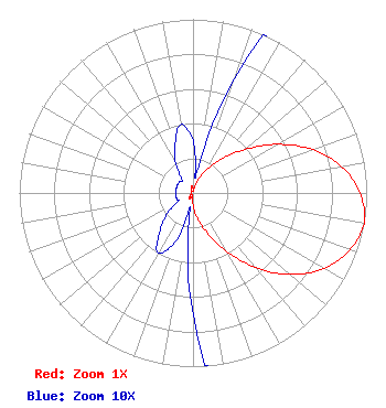 | ||||||||||||||||||
| Azimuth | Ratio | Azimuth | Ratio | Azimuth | Ratio | Azimuth | Ratio | ||||||||||||
| 0 | 0.030 | 10 | 0.010 | 20 | 0.070 | 30 | 0.150 | ||||||||||||
| 40 | 0.250 | 50 | 0.390 | 60 | 0.560 | 70 | 0.730 | ||||||||||||
| 80 | 0.870 | 90 | 0.960 | 100 | 1.000 | 110 | 0.960 | ||||||||||||
| 120 | 0.870 | 130 | 0.730 | 140 | 0.560 | 150 | 0.390 | ||||||||||||
| 160 | 0.250 | 170 | 0.150 | 180 | 0.070 | 190 | 0.010 | ||||||||||||
| 200 | 0.030 | 210 | 0.040 | 220 | 0.030 | 230 | 0.020 | ||||||||||||
| 240 | 0.010 | 250 | 0.010 | 260 | 0.010 | 270 | 0.010 | ||||||||||||
| 280 | 0.010 | 290 | 0.010 | 300 | 0.010 | 310 | 0.010 | ||||||||||||
| 320 | 0.010 | 330 | 0.020 | 340 | 0.030 | 350 | 0.040 | ||||||||||||
Structure Registration Number 1278248 Structure Type: LTOWER Registered To: CCATT LLC Structure Address: 91 Palehua Ridge Kapolei, HI County Name: Honolulu County ASR Issued: 05/09/2016 Date Built: 04/06/2007 Site Elevation: 829.1 m (2720 ft.) Structure Height: 45.7 m (150 ft.) Height Overall: 48.8 m (160 ft.) Overall Height AMSL: 877.9 m (2880 ft.) FAA Determination: 04/27/2016 FAA Study #: 2016-AWP-976-OE Paint & Light FAA Chapters: NONE PRIOR STUDY 2014-AWP-6507-OE 21-24-11.8 N 158-05-52.8 W (NAD 83) 21-24-23.2 N 158-06-02.7 W (Converted to NAD 27) |
38955 Hills Tech Dr. Farmington, HI 48331 Phone: 248-536-0776 Limited Liability Company | Title: President Date: 12/11/2023 Application Certifier Kailua Television, Llc P.o. Box 8969 Honolulu, HI 96810 Applicant Kevin T Fisher Smith And Fisher, Llc 4791 Wintergreen Court Woodbridge, VA 22192 Engineering Consultant Ari Meltzer, Esq Wiley Rein Llp 2050 M Street, N.w. Washington, DC 20036 | |||||||||||||||||