
FCCInfo.com
A Service of Cavell, Mertz & Associates, Inc.
(855) FCC-INFO
|
|
KSTR-DT from 10/15/1999 KSTR-DT from 12/28/1992 KSTR-DT from 06/01/1987 KSTR-DT from 06/27/1983 |
Post-repack Channel 34 Virtual Channel 49 |
|
|||||||||||||||||
|
|
Repacking Information: Pre-Repack Channel: 48 Post-Repack Channel: 34 Post-Repack ERP: 767 kW Phase: 3 Completion Deadline: 6/21/2019 Find nearby TV Facilities Status: License Application Accepted: 12/18/2023 License Expires: 08/01/2022 File Number: -0000233334 FCC Website Links: LMS Facility Details This Application Other KSTR-DT Applications Including Superseded Applications Mailing Address Correspondence for KSTR-DT Correspondence related to application -0000233334 Service Contour - Open Street Map or USGS Map (41 dBu) Service Contour - KML / Google Earth (41 dBu) Public Inspection Files Rabbit Ears Info Search for KSTR-DT Site Location: 32-32-35.4 N 96-57-32.9 W (NAD 83) Site Location: 32-32-34.9 N 96-57-31.9 W (Converted to NAD 27) ERP: 1000 kW Polarization: Elliptically polarized HAAT: 517 m (1696 ft.) Electrical Beam Tilt: 0.75 degrees R/C AGL: 472.1 m (1549 ft.) R/C AMSL: 719.9 m (2362 ft.) Site Elevation: 247.8 m. (813 ft.) Height Overall*: 500.2 m (1641 ft.) (* As Filed In This Application, may differ from ASR Data, Below.) Directional Antenna - Antenna Make/Model: R.F. Systems SAA26-KSTR-G300-ET6R-3433 Antenna ID: 1011336 Polarization: Elliptically polarized | |||||||||||||||||||
| Antenna Data for Antenna Id: 1011336 KSTR-DT DT File: -0000233334 R.F. Systems - SAA26-KSTR-G300-ET6R-3433 Service: DT Standard Pattern: N | 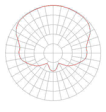 | |||||||||||||||||||
| Azimuth | Ratio | Azimuth | Ratio | Azimuth | Ratio | Azimuth | Ratio | |||||||||||||
| 0 | 1.000 | 10 | 0.997 | 20 | 0.987 | 30 | 0.981 | |||||||||||||
| 40 | 0.979 | 50 | 0.963 | 60 | 0.897 | 70 | 0.783 | |||||||||||||
| 80 | 0.710 | 83 | 0.706 | 90 | 0.713 | 100 | 0.686 | |||||||||||||
| 110 | 0.594 | 120 | 0.502 | 130 | 0.418 | 140 | 0.318 | |||||||||||||
| 150 | 0.252 | 160 | 0.283 | 170 | 0.350 | 180 | 0.380 | |||||||||||||
| 190 | 0.350 | 200 | 0.283 | 210 | 0.254 | 220 | 0.320 | |||||||||||||
| 230 | 0.420 | 240 | 0.502 | 250 | 0.595 | 260 | 0.686 | |||||||||||||
| 270 | 0.713 | 277 | 0.705 | 280 | 0.708 | 290 | 0.781 | |||||||||||||
| 300 | 0.894 | 310 | 0.960 | 320 | 0.976 | 330 | 0.978 | |||||||||||||
| 340 | 0.985 | 350 | 0.995 | |||||||||||||||||
Structure Registration Number 1059733 Structure Type: GTOWER Registered To: American Towers LLC Structure Address: 2133 Tar Rd (#282636) Cedar Hill, TX County Name: Ellis County ASR Issued: 04/03/2024 Date Built: 06/18/2000 Site Elevation: 247.8 m (813 ft.) Structure Height: 464.4 m (1524 ft.) Height Overall: 500.2 m (1641 ft.) Overall Height AMSL: 748 m (2454 ft.) FAA Determination: 04/10/2023 FAA Study #: 2022-ASW-23639-OE FAA Circular #: 70/7460-1M Paint & Light FAA Chapters: 4, 9, 15 PRIOR STUDY 2022-ASW-13327-OE 32-32-35.4 N 96-57-32.9 W (NAD 83) 32-32-34.9 N 96-57-31.9 W (Converted to NAD 27) |
101 Constitution Avenue, Nw, Suite 800w Washington, DC 20001 Phone: 310-348-3600 Limited Liability Company | Title: Senior Vice President Us Regulatory Date: 12/18/2023 Application Certifier UNIMAS DALLAS LLC Unimas Dallas Llc 101 Constitution Avenue, Nw, Suite 800w Washington, DC 20001 Applicant MATTHEW S. DELNERO Covington & Burling Llp One Citycenter 850 Tenth Street, Nw Washington, DC 20001 | ||||||||||||||||||
| ||||||||||||||||||||
