
FCCInfo.com
A Service of Cavell, Mertz & Associates, Inc.
(855) FCC-INFO
|
|
WIIW-LD from 07/17/2016 WIIW-LD from 06/01/2016 WIIW-LD from 08/01/2007 |
|
|
||||||||||||||||
|
|
Status: License Application Accepted: 12/13/2023 License Expires: 08/01/2029 File Number: -0000232650 FCC Website Links: LMS Facility Details This Application Other WIIW-LD Applications Including Superseded Applications Mailing Address Correspondence for WIIW-LD Correspondence related to application -0000232650 Service Contour - Open Street Map or USGS Map (51 dBu) Service Contour - KML / Google Earth (51 dBu) Rabbit Ears Info Search for WIIW-LD Site Location: 36-08-27.0 N 86-51-56.0 W (NAD 83) Site Location: 36-08-26.8 N 86-51-56.0 W (Converted to NAD 27) ERP: 15 kW Polarization: Elliptically polarized Electrical Beam Tilt: 0.75 degrees R/C AGL: 211.2 m (693 ft.) R/C AMSL: 416.9 m (1368 ft.) Emission Mask: Full Service Site Elevation: 205.7 m. (675 ft.) Height Overall*: 417.4 m (1369 ft.) (* As Filed In This Application, may differ from ASR Data, Below.) Directional Antenna - Antenna Make/Model: Alive ATC-BCE312UA-V1-14 Antenna ID: 1011319 Polarization: Elliptically polarized | ||||||||||||||||||
| Antenna Data for Antenna Id: 1011319 WIIW-LD LD File: -0000232650 Alive - ATC-BCE312UA-V1-14 Service: LD Standard Pattern: N | 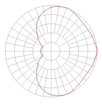 | ||||||||||||||||||
| Azimuth | Ratio | Azimuth | Ratio | Azimuth | Ratio | Azimuth | Ratio | ||||||||||||
| 0 | 0.950 | 10 | 0.980 | 20 | 1.000 | 30 | 0.975 | ||||||||||||
| 40 | 0.940 | 50 | 0.920 | 60 | 0.925 | 70 | 0.950 | ||||||||||||
| 80 | 0.970 | 90 | 1.000 | 100 | 0.970 | 110 | 0.950 | ||||||||||||
| 120 | 0.925 | 130 | 0.920 | 140 | 0.940 | 150 | 0.975 | ||||||||||||
| 160 | 1.000 | 170 | 0.980 | 180 | 0.950 | 190 | 0.875 | ||||||||||||
| 200 | 0.775 | 210 | 0.630 | 220 | 0.470 | 230 | 0.350 | ||||||||||||
| 240 | 0.230 | 250 | 0.220 | 260 | 0.225 | 270 | 0.230 | ||||||||||||
| 280 | 0.225 | 290 | 0.220 | 300 | 0.229 | 310 | 0.350 | ||||||||||||
| 320 | 0.470 | 330 | 0.630 | 340 | 0.775 | 350 | 0.875 | ||||||||||||
Structure Registration Number 1050735 Structure Type: GTOWER Registered To: Gray Media Group, Inc. Structure Address: 5700 Knob Road Nashville, TN County Name: Davidson County ASR Issued: 12/02/2021 Date Built: 01/01/1986 Site Elevation: 205.7 m (675 ft.) Structure Height: 391.4 m (1284 ft.) Height Overall: 417.4 m (1369 ft.) Overall Height AMSL: 623.1 m (2044 ft.) FAA Determination: 01/28/2021 FAA Study #: 2020-ASO-36673-OE FAA Circular #: 70/7460-1M Paint & Light FAA Chapters: 3, 4, 5, 15 PRIOR STUDY 1998-ASO-1912-OE 36-08-27.0 N 86-51-56.0 W (NAD 83) 36-08-26.8 N 86-51-56.0 W (Converted to NAD 27) |
38955 Hills Tech Dr. Farmington Hills, MI 48331 Phone: 248-536-0776 Limited Liability Company | Title: Ceo Date: 12/13/2023 Application Certifier Bridge News Llc 38955 Hills Tech Dr. Farmington Hills, MI 48331 Applicant Dan J Alpert The Law Office Of Dan J. Alpert 2120 21st Rd. N Arlington, VA 22201 Legal Counsel Erik C Swanson, PE Hatfield & Dawson 9500 Greenwood Ave N Seattle, WA 98103 Consulting Engineer | |||||||||||||||||