
FCCInfo.com
A Service of Cavell, Mertz & Associates, Inc.
(855) FCC-INFO
|
|
WBRL-CD from 11/26/2002 WBRL-CD from 09/08/1995 WBRL-CD from 01/08/1992 WBRL-CD from 01/12/1989 |
|
|
||||||||||||||||
|
|
Repacking Information: No changes Status: License Application Accepted: 12/12/2023 License Expires: 06/01/2021 File Number: -0000227323 FCC Website Links: LMS Facility Details This Application Other WBRL-CD Applications Including Superseded Applications Mailing Address Correspondence for WBRL-CD Correspondence related to application -0000227323 Service Contour - Open Street Map or USGS Map (51 dBu) Service Contour - KML / Google Earth (51 dBu) Public Inspection Files Rabbit Ears Info Search for WBRL-CD Site Location: 30-19-34.6 N 91-16-36.1 W (NAD 83) Site Location: 30-19-33.9 N 91-16-35.7 W (Converted to NAD 27) ERP: 10 kW Polarization: Horizontally polarized Electrical Beam Tilt: 0.75 degrees R/C AGL: 213.4 m (700 ft.) R/C AMSL: 217.1 m (712 ft.) Emission Mask: Simple Site Elevation: 3.7 m. (12 ft.) Height Overall*: 529.4 m (1737 ft.) (* As Filed In This Application, may differ from ASR Data, Below.) Directional Antenna - Antenna Make/Model: Andrew ALP-32L3-HSNR-21 Antenna ID: 89170 Polarization: Horizontally polarized | ||||||||||||||||||
| Antenna Data for Antenna Id: 89170 WBRL-CD DC File: -0000227323 Andrew - ALP-32L3-HSNR-21 Service: DC Standard Pattern: Y | 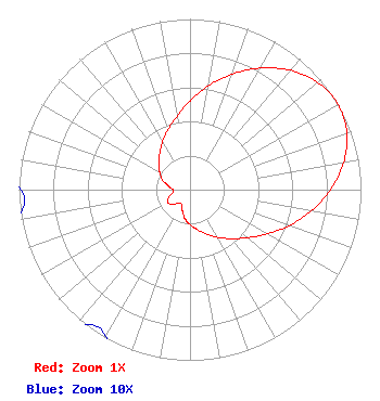 | ||||||||||||||||||
| Azimuth | Ratio | Azimuth | Ratio | Azimuth | Ratio | Azimuth | Ratio | ||||||||||||
| 0 | 0.520 | 10 | 0.617 | 20 | 0.721 | 30 | 0.822 | ||||||||||||
| 40 | 0.912 | 50 | 0.976 | 60 | 1.000 | 70 | 0.976 | ||||||||||||
| 80 | 0.912 | 90 | 0.822 | 100 | 0.721 | 110 | 0.617 | ||||||||||||
| 120 | 0.520 | 130 | 0.438 | 140 | 0.375 | 150 | 0.323 | ||||||||||||
| 160 | 0.276 | 170 | 0.237 | 180 | 0.205 | 190 | 0.172 | ||||||||||||
| 200 | 0.130 | 210 | 0.099 | 220 | 0.103 | 230 | 0.133 | ||||||||||||
| 240 | 0.151 | 250 | 0.133 | 260 | 0.103 | 270 | 0.099 | ||||||||||||
| 280 | 0.130 | 290 | 0.172 | 300 | 0.205 | 310 | 0.237 | ||||||||||||
| 320 | 0.276 | 330 | 0.323 | 340 | 0.375 | 350 | 0.438 | ||||||||||||
Structure Registration Number 1022810 Structure Type: TOWER Registered To: Pinnacle Towers LLC Structure Address: 1.9 Mi W Of St Hwy 1 On Hwy 1148 Addis, LA County Name: West Baton Rouge Parish ASR Issued: 05/06/2016 Date Built: 01/01/1986 Site Elevation: 3.7 m (12 ft.) Structure Height: 511.1 m (1677 ft.) Height Overall: 529.4 m (1737 ft.) Overall Height AMSL: 533.1 m (1749 ft.) FAA Determination: 07/11/2008 FAA Study #: 2008-ASW-4853-OE FAA Circular #: 70/7460-1K Paint & Light FAA Chapters: 4, 7, 12 PRIOR STUDY 1987-ASW-812-OE 30-19-34.6 N 91-16-36.1 W (NAD 83) 30-19-33.9 N 91-16-35.7 W (Converted to NAD 27) |
545 E. Carpenter Freeway Suite 700 Irving, TX 75062 Phone: 972-373-8800 Corporation | Title: Associate General Counsel Date: 12/12/2023 Application Certifier Nexstar Media Inc. 545 E. Carpenter Freeway Suite 700 Irving, TX 75062 Applicant Jason Roberts Nexstar Media Inc. 545 E John Carpenter Freeway Suite 700 Irving, TX 75062 Associate General Counsel | |||||||||||||||||
