
FCCInfo.com
A Service of Cavell, Mertz & Associates, Inc.
(855) FCC-INFO
|
|
|
Post-repack Channel 36 Virtual Channel 45 |
|
|||||||||||||||||
|
|
Repacking Information: Pre-Repack Channel: 30 Post-Repack Channel: 36 Post-Repack ERP: 563 kW Phase: 6 Completion Deadline: 10/18/2019 Upstream/Downstream Dependencies Other Linked Stations Find nearby TV Facilities Status: License Application Accepted: 12/19/2023 License Expires: 10/01/2021 File Number: -0000233417 FCC Website Links: LMS Facility Details This Application Other WRGT-TV Applications Including Superseded Applications Mailing Address Correspondence for WRGT-TV Correspondence related to application -0000233417 Service Contour - Open Street Map or USGS Map (41 dBu) Service Contour - KML / Google Earth (41 dBu) Public Inspection Files Rabbit Ears Info Search for WRGT-TV Site Location: 39-43-28.6 N 84-15-17.6 W (NAD 83) Site Location: 39-43-28.4 N 84-15-17.8 W (Converted to NAD 27) ERP: 1000 kW Polarization: Elliptically polarized HAAT: 351.0 m (1152 ft.) Electrical Beam Tilt: 0.75 degrees R/C AGL: 343 m (1125 ft.) R/C AMSL: 615.8 m (2020 ft.) Emission Mask: Simple Site Elevation: 272.8 m. (895 ft.) Height Overall*: 351.7 m (1154 ft.) (* As Filed In This Application, may differ from ASR Data, Below.) Directional Antenna - Antenna Make/Model: DIELECTRIC TFU-24ETT/VP-R S250 Antenna ID: 1011346 Polarization: Elliptically polarized | |||||||||||||||||||
| Antenna Data for Antenna Id: 1011346 WRGT-TV DT File: -0000233417 DIELECTRIC - TFU-24ETT/VP-R S250 Service: DT Standard Pattern: N | 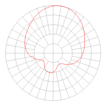 | |||||||||||||||||||
| Azimuth | Ratio | Azimuth | Ratio | Azimuth | Ratio | Azimuth | Ratio | |||||||||||||
| 0 | 0.986 | 10 | 1.000 | 20 | 0.986 | 30 | 0.945 | |||||||||||||
| 40 | 0.888 | 50 | 0.823 | 60 | 0.761 | 70 | 0.709 | |||||||||||||
| 80 | 0.667 | 90 | 0.630 | 100 | 0.588 | 110 | 0.532 | |||||||||||||
| 120 | 0.460 | 130 | 0.374 | 140 | 0.295 | 150 | 0.268 | |||||||||||||
| 160 | 0.287 | 170 | 0.349 | 180 | 0.402 | 190 | 0.422 | |||||||||||||
| 200 | 0.402 | 210 | 0.349 | 220 | 0.287 | 230 | 0.258 | |||||||||||||
| 240 | 0.295 | 250 | 0.374 | 260 | 0.460 | 270 | 0.532 | |||||||||||||
| 280 | 0.588 | 290 | 0.630 | 300 | 0.667 | 310 | 0.709 | |||||||||||||
| 320 | 0.761 | 330 | 0.823 | 340 | 0.888 | 350 | 0.945 | |||||||||||||
Structure Registration Number 1222924 Structure Type: GTOWER Registered To: American Towers LLC Structure Address: 2045 S. Gettysburg Ave. (#050893 / Dayton/ S Gettyburg) Dayton, OH County Name: Montgomery County ASR Issued: 03/29/2013 Date Built: 08/24/2001 Site Elevation: 272.8 m (895 ft.) Structure Height: 307.8 m (1010 ft.) Height Overall: 351.7 m (1154 ft.) Overall Height AMSL: 624.5 m (2049 ft.) FAA Determination: 03/14/2013 FAA Study #: 2013-AGL-2613-OE FAA Circular #: 70/7460-1K Paint & Light FAA Chapters: 4, 7, 12 PRIOR STUDY 2012-AGL-148-OE 39-43-28.6 N 84-15-17.6 W (NAD 83) 39-43-28.4 N 84-15-17.8 W (Converted to NAD 27) |
2000 West 41st Street Baltimore, MD 21211 Phone: 410-662-9688 Limited Liability Company | Title: Secretary Date: 12/19/2023 Application Certifier Wrgt Licensee, Llc 2000 West 41st Street Baltimore, MD 21211 Applicant Kevin Fisher Smith And Fisher, Llc 4791 Wintergreen Court Woodbridge, VA 22192 Scott R. Flick, Esq Pillsbury Winthrop Shaw Pittman Llp 1200 Seventeenth Street Nw Washington, DC 20036 | ||||||||||||||||||
