
FCCInfo.com
A Service of Cavell, Mertz & Associates, Inc.
(855) FCC-INFO
|
|
WRUG-LD from 03/26/2013 WRUG-LD from 05/29/2012 |
|
|
||||||||||||||||
|
|
Status: Construction Permit Application Accepted: 01/11/2024 WRUG-LD CP Expires: 02/28/2026 File Number: -0000235235 FCC Website Links: LMS Facility Details This Application Other WRUG-LD Applications Including Superseded Applications Mailing Address Correspondence for WRUG-LD Correspondence related to application -0000235235 Service Contour - Open Street Map or USGS Map (51 dBu) Service Contour - KML / Google Earth (51 dBu) Rabbit Ears Info Search for WRUG-LD Site Location: 30-25-04.6 N 91-00-31.7 W (NAD 83) Site Location: 30-25-03.9 N 91-00-31.3 W (Converted to NAD 27) ERP: 8.35 kW Polarization: Horizontally polarized R/C AGL: 62.5 m (205 ft.) R/C AMSL: 71.9 m (236 ft.) Emission Mask: Full Service Site Elevation: 9.4 m. (31 ft.) Height Overall*: 76.8 m (252 ft.) (* As Filed In This Application, may differ from ASR Data, Below.) Directional Antenna - Antenna Make/Model: Propagation System Inc PSILP12AER Antenna ID: 20349 Polarization: Horizontally polarized | ||||||||||||||||||
| Antenna Data for Antenna Id: 20349 WRUG-LD LD File: -0000235235 Propagation System Inc - PSILP12AER Service: LD Standard Pattern: Y Pattern and Field Values Include a 294.0° Clockwise Rotation | 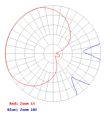 | ||||||||||||||||||
| Azimuth | Ratio | Azimuth | Ratio | Azimuth | Ratio | Azimuth | Ratio | ||||||||||||
| 4 | 0.886 | 14 | 0.815 | 24 | 0.725 | 34 | 0.624 | ||||||||||||
| 44 | 0.529 | 54 | 0.428 | 64 | 0.293 | 74 | 0.146 | ||||||||||||
| 84 | 0.067 | 94 | 0.085 | 104 | 0.136 | 114 | 0.147 | ||||||||||||
| 124 | 0.136 | 134 | 0.085 | 144 | 0.067 | 154 | 0.146 | ||||||||||||
| 164 | 0.293 | 174 | 0.428 | 184 | 0.529 | 194 | 0.624 | ||||||||||||
| 204 | 0.725 | 214 | 0.815 | 224 | 0.886 | 234 | 0.946 | ||||||||||||
| 244 | 0.988 | 254 | 1.000 | 264 | 1.000 | 274 | 1.000 | ||||||||||||
| 284 | 1.000 | 294 | 1.000 | 304 | 1.000 | 314 | 1.000 | ||||||||||||
| 324 | 1.000 | 334 | 1.000 | 344 | 0.988 | 354 | 0.946 | ||||||||||||
Structure Registration Number 1038164 Structure Type: LTOWER Registered To: American Towers LLC Structure Address: 3885 O'neal Lane (304830) Baton Rouge, LA County Name: East Baton Rouge Parish ASR Issued: 02/08/2024 Date Built: 08/16/2009 Site Elevation: 9.4 m (31 ft.) Structure Height: 75.3 m (247 ft.) Height Overall: 76.8 m (252 ft.) Overall Height AMSL: 86.2 m (283 ft.) FAA Determination: 03/09/2023 FAA Study #: 2022-ASW-7476-OE FAA Circular #: 70/7460-1J Paint & Light FAA Chapters: 4, 8, 13 PRIOR STUDY 2009-ASW-3782-OE 30-25-04.6 N 91-00-31.6 W (NAD 83) 30-25-03.9 N 91-00-31.2 W (Converted to NAD 27) |
Chattanooga, TN 37401 Phone: 423-468-5100 Limited Liability Company | Title: Coo Date: 01/11/2024 Application Certifier Digital Networks-Southeast, LLC Digital Networks-southeast, Llc Chattanooga, TN 37401 Applicant Timothy Z Sawyer T Z Sawyer Technical Consultants 2130 Hutchison Grove Court Suite 100 Falls Church, VA 22043 Technical Consultant Aaron P Shainis, Esq Shainis & Peltzman, Chartered 1850 M Street Nw Suite 240 Washington, DC 20036 FCC Counsel | |||||||||||||||||