
FCCInfo.com
A Service of Cavell, Mertz & Associates, Inc.
(855) FCC-INFO
|
|
|
Virtual Channel 6 |
|
||||||||||||||||||||||||||||
|
|
Status: STA – Special Temporary Authority Application Accepted: 02/06/2024 STA Expires: 08/25/2024 File Number: -0000238390 FCC Website Links: LMS Facility Details This Application Other WJAC-TV Applications Including Superseded Applications Mailing Address Correspondence for WJAC-TV Correspondence related to application -0000238390 Service Contour - Open Street Map or USGS Map (51 dBu) Service Contour - KML / Google Earth (51 dBu) History Cards for WJAC-TV Rabbit Ears Info Search for WJAC-TV Site Location: 41-02-43.0 N 78-42-10.0 W (NAD 83) Site Location: 41-02-42.8 N 78-42-10.9 W (Converted to NAD 27) ERP: 0.35 kW Polarization: Horizontally polarized Electrical Beam Tilt: 1 degree R/C AGL: 74 m (243 ft.) R/C AMSL: 696 m (2283 ft.) Emission Mask: Stringent Site Elevation: 622 m. (2041 ft.) Height Overall*: 98 m (322 ft.) (* As Filed In This Application, may differ from ASR Data, Below.) Directional Antenna - Antenna Make/Model: DIELECTRIC TUL-C3-01/03M-T Antenna ID: 106678 Polarization: Horizontally polarized
| ||||||||||||||||||||||||||||||
| Antenna Data for Antenna Id: 106678 WJAC-TV LD File: -0000238390 DIELECTRIC - TUL-C3-01/03M-T Service: LD Standard Pattern: Y | 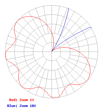 | ||||||||||||||||||||||||||||||
| Azimuth | Ratio | Azimuth | Ratio | Azimuth | Ratio | Azimuth | Ratio | ||||||||||||||||||||||||
| 0 | 0.415 | 10 | 0.253 | 20 | 0.120 | 30 | 0.032 | ||||||||||||||||||||||||
| 40 | 0.001 | 50 | 0.032 | 60 | 0.120 | 70 | 0.253 | ||||||||||||||||||||||||
| 80 | 0.415 | 90 | 0.585 | 100 | 0.744 | 110 | 0.873 | ||||||||||||||||||||||||
| 120 | 0.957 | 130 | 0.986 | 140 | 0.926 | 150 | 0.818 | ||||||||||||||||||||||||
| 160 | 0.850 | 170 | 0.977 | 175 | 1.000 | 180 | 0.977 | ||||||||||||||||||||||||
| 190 | 0.850 | 200 | 0.818 | 210 | 0.926 | 220 | 0.986 | ||||||||||||||||||||||||
| 230 | 0.926 | 240 | 0.818 | 250 | 0.850 | 260 | 0.977 | ||||||||||||||||||||||||
| 265 | 1.000 | 270 | 0.977 | 280 | 0.850 | 290 | 0.818 | ||||||||||||||||||||||||
| 300 | 0.926 | 310 | 0.986 | 320 | 0.957 | 330 | 0.873 | ||||||||||||||||||||||||
| 340 | 0.744 | 350 | 0.585 | ||||||||||||||||||||||||||||
Structure Registration Number 1025586 Structure Type: TOWER Registered To: Seven Mountains Media, LLC Structure Address: Along Rt 219 1 Mi E Luthersburg, PA County Name: Clearfield County ASR Issued: 02/12/2024 Date Built: 01/01/1992 Site Elevation: 622 m (2041 ft.) Structure Height: 90.9 m (298 ft.) Height Overall: 98 m (322 ft.) Overall Height AMSL: 720 m (2362 ft.) FAA Determination: 08/18/1992 FAA Study #: 92-AEA-1330-OE Paint & Light FAA Chapters: A1, H MEDIUM INTENSITY WHITE LIGHTS 41-02-43.0 N 78-42-10.0 W (NAD 83) 41-02-42.8 N 78-42-10.9 W (Converted to NAD 27) |
1200 Seventeenth Street, Nw Washington, DC 20036 Phone: 202-663-8195 Limited Liability Company | Title: Cfo Date: 02/06/2024 Application Certifier Wjac Licensee, Llc 1200 Seventeenth Street, Nw Washington, DC 20036 Applicant John E Hidle Carl T. Jones Corporation 7901 Yarnwood Court Springfield, VA 22135 Consulting Engineer Paul A Cicelski Lerman Senter Pllc 2001 L Street, Nw Suite 400 Washington, DC 20036 Legal Counsel | |||||||||||||||||||||||||||||
|
| ||||||||||||||||||||||||||||||