
FCCInfo.com
A Service of Cavell, Mertz & Associates, Inc.
(855) FCC-INFO
|
|
WTNB-CD from 06/12/2003 WTNB-CD from 07/01/1998 WTNB-CD from 12/08/1994 |
Post-repack Channel 5 |  |
|
|||||||||||||||
|
|
Repacking Information: Pre-Repack Channel: 27 Post-Repack Channel: 5 Post-Repack ERP: 1.67 kW Phase: 5 Completion Deadline: 9/11/2019 Upstream/Downstream Dependencies Other Linked Stations Find nearby TV Facilities Status: License Application Accepted: 02/16/2024 License Expires: 08/01/2029 File Number: -0000239097 FCC Website Links: LMS Facility Details This Application Other WTNB-CD Applications Including Superseded Applications Mailing Address Correspondence for WTNB-CD Correspondence related to application -0000239097 Service Contour - Open Street Map or USGS Map (43 dBu) Service Contour - KML / Google Earth (43 dBu) Public Inspection Files Rabbit Ears Info Search for WTNB-CD Site Location: 35-12-26.0 N 85-16-52.0 W (NAD 83) Site Location: 35-12-25.7 N 85-16-52.1 W (Converted to NAD 27) ERP: 3 kW Polarization: Circularly polarized Electrical Beam Tilt: 0.5 degrees R/C AGL: 106.7 m (350 ft.) R/C AMSL: 720 m (2362 ft.) Emission Mask: Simple Site Elevation: 613.3 m. (2012 ft.) Height Overall*: 135.6 m (445 ft.) (* As Filed In This Application, may differ from ASR Data, Below.) Directional Antenna - Antenna Make/Model: DIELECTRIC DCRQ2C50T050 Antenna ID: 1011486 Polarization: Circularly polarized | ||||||||||||||||||
| Antenna Data for Antenna Id: 1011486 WTNB-CD DC File: -0000239097 DIELECTRIC - DCRQ2C50T050 Service: DC Standard Pattern: N | 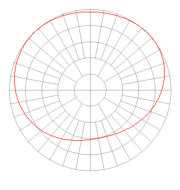 | ||||||||||||||||||
| Azimuth | Ratio | Azimuth | Ratio | Azimuth | Ratio | Azimuth | Ratio | ||||||||||||
| 0 | 0.964 | 10 | 0.966 | 20 | 0.975 | 30 | 0.987 | ||||||||||||
| 40 | 0.997 | 50 | 1.000 | 60 | 0.990 | 70 | 0.968 | ||||||||||||
| 80 | 0.932 | 90 | 0.887 | 100 | 0.837 | 110 | 0.785 | ||||||||||||
| 120 | 0.736 | 130 | 0.693 | 140 | 0.656 | 150 | 0.630 | ||||||||||||
| 160 | 0.613 | 170 | 0.609 | 180 | 0.616 | 190 | 0.634 | ||||||||||||
| 200 | 0.662 | 210 | 0.698 | 220 | 0.738 | 230 | 0.780 | ||||||||||||
| 240 | 0.821 | 250 | 0.859 | 260 | 0.893 | 270 | 0.922 | ||||||||||||
| 280 | 0.946 | 290 | 0.965 | 300 | 0.978 | 310 | 0.986 | ||||||||||||
| 320 | 0.987 | 330 | 0.983 | 340 | 0.976 | 350 | 0.968 | ||||||||||||
Structure Registration Number 1042763 Structure Type: GTOWER Registered To: GREATER CHATTANOOGA PUBLIC TELEVISION CORPORATION Structure Address: Sawyer Cemetery Rd Signal Mountain, TN County Name: Hamilton County ASR Issued: 06/09/2022 Date Built: 06/10/2022 Site Elevation: 613.3 m (2012 ft.) Structure Height: 135.6 m (445 ft.) Height Overall: 135.6 m (445 ft.) Overall Height AMSL: 748.9 m (2457 ft.) FAA Determination: 09/09/2014 FAA Study #: 2014-ASO-8387-OE FAA Circular #: 70/7460-1K Paint & Light FAA Chapters: 3, 4, 5, 12 PRIOR STUDY 1992-ASO-1871-OE 35-12-26.0 N 85-16-52.0 W (NAD 83) 35-12-25.7 N 85-16-52.1 W (Converted to NAD 27) |
6922 142nd Ave Largo, FL 33771 Phone: 727-535-5622 Not-for-Profit | Title: President Date: 02/16/2024 Application Certifier VOLUNTEER CHRISTIAN TELEVISION, INC. Volunteer Christian Television, Inc. 6922 142nd Ave Largo, FL 33771 Applicant JOSEPH C. CHAUTIN, III Hardy, Carey, Chautin & Balkin, Llp 1080 West Causeway Approach Mandeville, LA 70471 Esq. | |||||||||||||||||