
FCCInfo.com
A Service of Cavell, Mertz & Associates, Inc.
(855) FCC-INFO
|
|
W45BZ from 08/12/1999 W45BZ from 08/12/1998 W45BZ from 03/14/1997 W45BZ from 03/28/1995 |
|
|
||||||||||||||||
|
|
Status: License Application Accepted: 02/20/2024 License Expires: 02/01/2029 File Number: -0000239481 FCC Website Links: LMS Facility Details This Application Other W26EX-D Applications Including Superseded Applications Mailing Address Correspondence for W26EX-D Correspondence related to application -0000239481 Service Contour - Open Street Map or USGS Map (51 dBu) Service Contour - KML / Google Earth (51 dBu) Rabbit Ears Info Search for W26EX-D Site Location: 30-16-35.0 N 81-33-50.7 W (NAD 83) Site Location: 30-16-34.1 N 81-33-51.4 W (Converted to NAD 27) ERP: 15 kW Polarization: Elliptically polarized Electrical Beam Tilt: 1.25 degrees R/C AGL: 118.3 m (388 ft.) R/C AMSL: 127.4 m (418 ft.) Emission Mask: Full Service Site Elevation: 9.1 m. (30 ft.) Height Overall*: 323.4 m (1061 ft.) (* As Filed In This Application, may differ from ASR Data, Below.) Directional Antenna - Antenna Make/Model: Alive ATC-BCE512CEC-V1-26 Antenna ID: 1011496 Polarization: Elliptically polarized | ||||||||||||||||||
| Antenna Data for Antenna Id: 1011496 W26EX-D LD File: -0000239481 Alive - ATC-BCE512CEC-V1-26 Service: LD Standard Pattern: N Pattern and Field Values Include a 270° Clockwise Rotation | 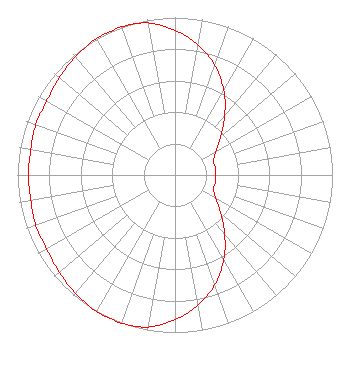 | ||||||||||||||||||
| Azimuth | Ratio | Azimuth | Ratio | Azimuth | Ratio | Azimuth | Ratio | ||||||||||||
| 0 | 0.920 | 10 | 0.840 | 20 | 0.740 | 30 | 0.620 | ||||||||||||
| 40 | 0.490 | 50 | 0.380 | 60 | 0.300 | 70 | 0.260 | ||||||||||||
| 80 | 0.260 | 90 | 0.260 | 100 | 0.260 | 110 | 0.260 | ||||||||||||
| 120 | 0.300 | 130 | 0.380 | 140 | 0.490 | 150 | 0.620 | ||||||||||||
| 160 | 0.740 | 170 | 0.840 | 180 | 0.920 | 190 | 0.980 | ||||||||||||
| 200 | 1.000 | 210 | 1.000 | 220 | 0.980 | 230 | 0.960 | ||||||||||||
| 240 | 0.940 | 250 | 0.940 | 260 | 0.930 | 270 | 0.930 | ||||||||||||
| 280 | 0.930 | 290 | 0.940 | 300 | 0.940 | 310 | 0.960 | ||||||||||||
| 320 | 0.980 | 330 | 1.000 | 340 | 1.000 | 350 | 0.980 | ||||||||||||
Structure Registration Number 1020783 Structure Type: GTOWER Registered To: American Towers, LLC Structure Address: 8541 Newton Rd (#302757) Jacksonville, FL County Name: Duval County ASR Issued: 02/07/2020 Date Built: 11/05/2008 Site Elevation: 9.1 m (30 ft.) Structure Height: 317.9 m (1043 ft.) Height Overall: 323.4 m (1061 ft.) Overall Height AMSL: 332.5 m (1091 ft.) FAA Determination: 12/02/2014 FAA Study #: 2014-ASO-12162-OE FAA Circular #: 70/7460-1K Paint & Light FAA Chapters: 4, 7, 12 PRIOR STUDY 2013-ASO-4505-OE 30-16-35.0 N 81-33-50.7 W (NAD 83) 30-16-34.1 N 81-33-51.4 W (Converted to NAD 27) |
11802 Aurellio Ln Orlando, FL 32827 Phone: 212-786-2365 Limited Liability Company | Title: Owner Date: 02/20/2024 Application Certifier 120 Commerce Drive Suite 120-a Plano, TX 75093 Applicant James Stenberg Over The Air Rf Consulting Llc 25 Stroudwater Road Portland, ME 04102 DEEPAK VISWANATH 120 Commerce Drive Suite 120-a Plano, TX 75093 AARON P SHAINIS Shainis & Peltzman, Chartered 1850 M Street Nw Suite 240 Washington, DC 20036 LEGAL COUNSEL | |||||||||||||||||