
FCCInfo.com
A Service of Cavell, Mertz & Associates, Inc.
(855) FCC-INFO
|
|
|
Virtual Channel 13 |  |
|
|||||||||||||||||||||||||||
|
|
Repacking Information: No changes Status: Construction Permit Application Accepted: 04/04/2024 KIPT CP Expires: 04/10/2027 File Number: -0000243106 FCC Website Links: LMS Facility Details This Application Other KIPT Applications Including Superseded Applications Mailing Address Correspondence for KIPT Correspondence related to application -0000243106 Service Contour - Open Street Map or USGS Map (41 dBu) Service Contour - KML / Google Earth (41 dBu) Public Inspection Files Rabbit Ears Info Search for KIPT DTS Site Number: 2 Site Location: 43-16-50.0 N 114-09-17.0 W (NAD 83) Site Location: 43-16-50.3 N 114-09-13.9 W (Converted to NAD 27) ERP: 0.1 kW Polarization: Horizontally polarized HAAT: 487 m (1598 ft.) R/C AGL: 12.2 m (40 ft.) R/C AMSL: 2015.7 m (6613 ft.) Site Elevation: 2003.5 m. (6573 ft.) Height Overall*: 39.6 m (130 ft.) (* As Filed In This Application, may differ from ASR Data, Below.) Directional Antenna - Antenna Make/Model: Scala 4DR-8S Antenna ID: 20753 Polarization: Horizontally polarized
| ||||||||||||||||||||||||||||||
| Antenna Data for Antenna Id: 20753 KIPT DD File: -0000243106 Scala - 4DR-8S Service: DD Standard Pattern: Y | 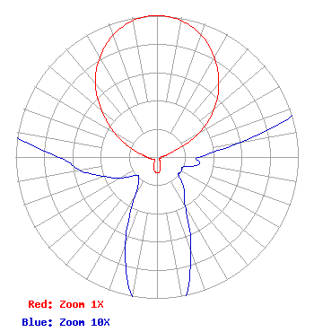 | ||||||||||||||||||||||||||||||
| Azimuth | Ratio | Azimuth | Ratio | Azimuth | Ratio | Azimuth | Ratio | ||||||||||||||||||||||||
| 0 | 1.000 | 10 | 0.980 | 20 | 0.917 | 30 | 0.813 | ||||||||||||||||||||||||
| 40 | 0.680 | 50 | 0.530 | 60 | 0.350 | 70 | 0.140 | ||||||||||||||||||||||||
| 80 | 0.060 | 90 | 0.030 | 100 | 0.030 | 110 | 0.020 | ||||||||||||||||||||||||
| 120 | 0.020 | 130 | 0.020 | 140 | 0.030 | 150 | 0.040 | ||||||||||||||||||||||||
| 160 | 0.070 | 170 | 0.105 | 180 | 0.110 | 190 | 0.100 | ||||||||||||||||||||||||
| 200 | 0.065 | 210 | 0.030 | 220 | 0.020 | 230 | 0.020 | ||||||||||||||||||||||||
| 240 | 0.030 | 250 | 0.040 | 260 | 0.055 | 270 | 0.070 | ||||||||||||||||||||||||
| 280 | 0.115 | 290 | 0.210 | 300 | 0.350 | 310 | 0.510 | ||||||||||||||||||||||||
| 320 | 0.680 | 330 | 0.810 | 340 | 0.915 | 350 | 0.980 | ||||||||||||||||||||||||
Structure Registration Number 1234527 Structure Type: LTOWER Registered To: American Towers LLC Structure Address: Picabo Mt. (207818) Gannett, ID County Name: Blaine County ASR Issued: 12/29/2022 Date Built: 01/02/2003 Site Elevation: 2003.5 m (6573 ft.) Structure Height: 39.6 m (130 ft.) Height Overall: 39.6 m (130 ft.) Overall Height AMSL: 2043.1 m (6703 ft.) FAA Determination: 12/15/2022 FAA Study #: 2022-ANM-3312-OE Paint & Light FAA Chapters: NONE PRIOR STUDY 2002-ANM-785-OE 43-16-50.0 N 114-09-17.0 W (NAD 83) 43-16-50.3 N 114-09-13.9 W (Converted to NAD 27) |
1455 North Orchard Street Attn: Craig Koster Boise, ID 83706 Phone: 208-373-7220 Fax: 208-373-7245 Government Entity | Title: Director Of Technology Date: 04/04/2024 Application Certifier IDAHO PUBLIC TELEVISION State Board Of Education, State Of Idaho 1455 North Orchard Street Attn: Craig Koster Boise, ID 83706 Phone: 208-373-7245 Applicant ANNE GOODWIN CRUMP, ESQ Fletcher, Heald And Hildreth, P.l.c. 1300 North 17th Street 11th Floor Arlington, VA 22209 Carl E. Gluck Carl T. Jones Corporation 7901 Yarnwood Court Springfield, VA 22153-2827 Technical Consultant | |||||||||||||||||||||||||||||
| |||||||||||||||||||||||||||||||