
FCCInfo.com
A Service of Cavell, Mertz & Associates, Inc.
(855) FCC-INFO
|
|
K24NR-D from 07/26/2004 |
|
|
||||||||||||||||
|
|
Status: License Application Accepted: 07/30/2007 License Expires: 08/01/2022 File Number: BLTTL-20070730AKW Prefix Type: This is a license for a UHF LPTV station FCC Website Links: LMS Facility Details This Application Other K24NR-D Applications Including Superseded Applications Mailing Address Correspondence for K24NR-D Correspondence related to application BLTTL-20070730AKW Service Contour - Open Street Map or USGS Map (74 dBu) Service Contour - KML / Google Earth (74 dBu) Rabbit Ears Info Search for K24NR-D Site Location: 35-16-26.8 N 101-34-38.9 W (NAD 83) Site Location: 35-16-26.6 N 101-34-37.3 W (Converted to NAD 27) ERP: 0.1 kW R/C AGL: 7 m (23 ft.) R/C AMSL: 1082 m (3550 ft.) Site Elevation: 1075 m. (3527 ft.) Height Overall*: 76.2 m (250 ft.) (* As Filed In This Application, may differ from ASR Data, Below.) Directional Antenna - Antenna Make/Model: Scala CL-1469 Antenna ID: 20778 | ||||||||||||||||||
| Antenna Data for Antenna Id: 20778 K24NR-D TX File: BLTTL-20070730AKW Scala - CL-1469 Service: TX Standard Pattern: Y Pattern and Field Values Include a 330° Clockwise Rotation | 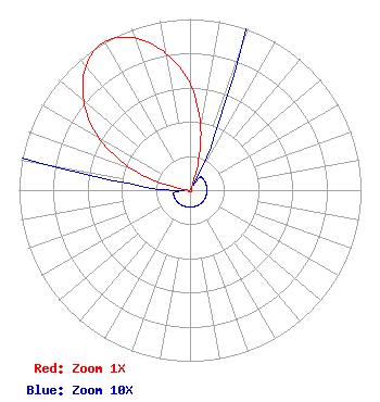 | ||||||||||||||||||
| Azimuth | Ratio | Azimuth | Ratio | Azimuth | Ratio | Azimuth | Ratio | ||||||||||||
| 0 | 0.622 | 10 | 0.361 | 20 | 0.086 | 30 | 0.010 | ||||||||||||
| 40 | 0.010 | 50 | 0.010 | 60 | 0.010 | 70 | 0.010 | ||||||||||||
| 80 | 0.010 | 90 | 0.010 | 100 | 0.010 | 110 | 0.010 | ||||||||||||
| 120 | 0.010 | 130 | 0.010 | 140 | 0.010 | 150 | 0.010 | ||||||||||||
| 160 | 0.010 | 170 | 0.010 | 180 | 0.010 | 190 | 0.010 | ||||||||||||
| 200 | 0.010 | 210 | 0.010 | 220 | 0.010 | 230 | 0.010 | ||||||||||||
| 240 | 0.010 | 250 | 0.010 | 260 | 0.010 | 270 | 0.010 | ||||||||||||
| 280 | 0.086 | 290 | 0.361 | 300 | 0.622 | 310 | 0.812 | ||||||||||||
| 320 | 0.947 | 330 | 1.000 | 340 | 0.947 | 350 | 0.812 | ||||||||||||
Structure Registration Number 1064843 Structure Type: TOWER Registered To: American Towers LLC Structure Address: 22310 U.s. Hwy 60 (pantex #75624) Amarillo, TX County Name: Carson County ASR Issued: 06/24/2016 Date Built: 07/23/2009 Site Elevation: 1075 m (3527 ft.) Structure Height: 73.8 m (242 ft.) Height Overall: 76.2 m (250 ft.) Overall Height AMSL: 1151.2 m (3777 ft.) FAA Determination: 07/22/2009 FAA Study #: 2009-ASW-3448-OE FAA Circular #: 70/7460-1J Paint & Light FAA Chapters: 4, 8, 13 PRIOR STUDY 2004-ASW-5538-OE 35-16-26.8 N 101-34-38.9 W (NAD 83) 35-16-26.6 N 101-34-37.3 W (Converted to NAD 27) |
1498 Buford Hwy Ste C 275 Sugar Hill, GA 30518 Phone: 770-771-1644 Corporation | Date: 07/30/2007 Application Certifier PRISM BROADCASTING NETWORK, INC. 7742 Spalding Dr. Suite 475 Norcross, GA 30092 Applicant B. W. ST. CLAIR 2355 Ranch Drive Westminster, CO 80234 ENGINEERING CONSULTANT PRISM BROADCASTING NETWORK, INC. | |||||||||||||||||