
FCCInfo.com
A Service of Cavell, Mertz & Associates, Inc.
(855) FCC-INFO
|
|
WYMI-LD from 10/07/2011 WYMI-LD from 08/05/2003 |
|
|
||||||||||||||||
|
|
Status: License Application Accepted: 08/03/2006 License Expires: 02/01/2021 File Number: BLTTL-20060803ALL Prefix Type: This is a license for a UHF LPTV station FCC Website Links: LMS Facility Details This Application Other WYMI-LD Applications Including Superseded Applications Mailing Address Correspondence for WYMI-LD Correspondence related to application BLTTL-20060803ALL Service Contour - Open Street Map or USGS Map (74 dBu) Service Contour - KML / Google Earth (74 dBu) Rabbit Ears Info Search for WYMI-LD Site Location: 24-40-37.4 N 81-30-38.0 W (NAD 83) Site Location: 24-40-35.9 N 81-30-38.7 W (Converted to NAD 27) ERP: 60 kW R/C AGL: 150 m (492 ft.) R/C AMSL: 151.2 m (496 ft.) Site Elevation: 1.2 m. (4 ft.) Height Overall*: 185 m (607 ft.) (* As Filed In This Application, may differ from ASR Data, Below.) Directional Antenna - Antenna Make/Model: Andrew ALP16L2-HSNR Antenna ID: 45028 | ||||||||||||||||||
| Antenna Data for Antenna Id: 45028 WYMI-LD TX File: BLTTL-20060803ALL Andrew - ALP16L2-HSNR Service: TX Standard Pattern: Y Pattern and Field Values Include a 240° Clockwise Rotation | 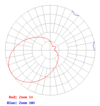 | ||||||||||||||||||
| Azimuth | Ratio | Azimuth | Ratio | Azimuth | Ratio | Azimuth | Ratio | ||||||||||||
| 0 | 0.200 | 10 | 0.170 | 20 | 0.130 | 30 | 0.100 | ||||||||||||
| 40 | 0.100 | 50 | 0.130 | 60 | 0.150 | 70 | 0.130 | ||||||||||||
| 80 | 0.100 | 90 | 0.100 | 100 | 0.130 | 110 | 0.170 | ||||||||||||
| 120 | 0.200 | 130 | 0.240 | 140 | 0.280 | 150 | 0.320 | ||||||||||||
| 160 | 0.380 | 170 | 0.440 | 180 | 0.520 | 190 | 0.620 | ||||||||||||
| 200 | 0.720 | 210 | 0.820 | 220 | 0.910 | 230 | 0.980 | ||||||||||||
| 240 | 1.000 | 250 | 0.980 | 260 | 0.910 | 270 | 0.820 | ||||||||||||
| 280 | 0.720 | 290 | 0.620 | 300 | 0.520 | 310 | 0.440 | ||||||||||||
| 320 | 0.380 | 330 | 0.320 | 340 | 0.280 | 350 | 0.240 | ||||||||||||
Structure Registration Number 1053369 Structure Type: GTOWER Registered To: Vertical Bridge CC FM, LLC Structure Address: Mm 23 Us 1 Off Blimp Rd Cudjoe Key, FL County Name: Monroe County ASR Issued: 03/22/2018 Date Built: 06/02/2012 Site Elevation: 1.2 m (4 ft.) Structure Height: 184 m (604 ft.) Height Overall: 185 m (607 ft.) Overall Height AMSL: 186.2 m (611 ft.) FAA Determination: 03/12/2018 FAA Study #: 2017-ASO-17876-OE FAA Circular #: 70/7460-1L Paint & Light FAA Chapters: 4, 8, 12 Removed expiration date from determination. Scenario 1./jjs/case#635066 24-40-37.4 N 81-30-38.0 W (NAD 83) 24-40-35.9 N 81-30-38.7 W (Converted to NAD 27) |
7812 W. Sage Creek Ct. Tuscon, AZ 85743 Phone: 520-971-9274 Corporation | Date: 08/03/2006 Application Certifier IGLESIA JESUCRISTO ES MI REFUGIO, INC. P.o. Box 223985 Dallas, TX 75222 Applicant ANTONIO CESAR GUEL 1482 Oakwood Lane Balch Springs, TX 75180 CONSULTANT JOHN JOSEPH MCVEIGH, ESQ. J.j. Mcveigh, Attorney At Law | |||||||||||||||||