
FCCInfo.com
A Service of Cavell, Mertz & Associates, Inc.
(855) FCC-INFO
|
|
|
|
|
||||||||||||||||
|
|
Status: License Application Accepted: 07/15/2013 License Expires: 02/01/2023 File Number: BLDTL-20130715ADK Prefix Type: This is BLDTL FCC Website Links: LMS Facility Details This Application Other K31KT-D Applications Including Superseded Applications Mailing Address Correspondence for K31KT-D Correspondence related to application BLDTL-20130715ADK Service Contour - Open Street Map or USGS Map (51 dBu) Service Contour - KML / Google Earth (51 dBu) Rabbit Ears Info Search for K31KT-D Site Location: 47-11-47.8 N 119-13-33.4 W (NAD 83) Site Location: 47-11-48.3 N 119-13-29.3 W (Converted to NAD 27) ERP: 1 kW R/C AGL: 60 m (197 ft.) R/C AMSL: 447.1 m (1467 ft.) Emission Mask: Simple Site Elevation: 387.1 m. (1270 ft.) Height Overall*: 65.5 m (215 ft.) (* As Filed In This Application, may differ from ASR Data, Below.) Directional Antenna - Antenna Make/Model: Scala 4DR-4-2HW Antenna ID: 20741 | ||||||||||||||||||
| Antenna Data for Antenna Id: 20741 K31KT-D LD File: BLDTL-20130715ADK Scala - 4DR-4-2HW Service: LD Standard Pattern: Y Pattern and Field Values Include a 240° Clockwise Rotation | 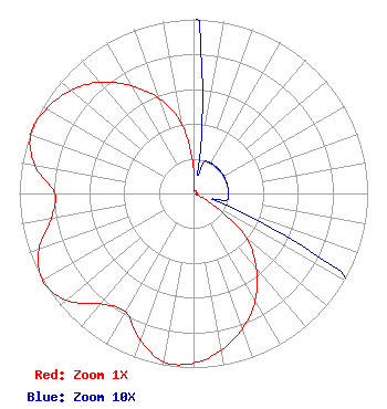 | ||||||||||||||||||
| Azimuth | Ratio | Azimuth | Ratio | Azimuth | Ratio | Azimuth | Ratio | ||||||||||||
| 0 | 0.135 | 10 | 0.020 | 20 | 0.020 | 30 | 0.020 | ||||||||||||
| 40 | 0.020 | 50 | 0.020 | 60 | 0.020 | 70 | 0.020 | ||||||||||||
| 80 | 0.020 | 90 | 0.020 | 100 | 0.020 | 110 | 0.020 | ||||||||||||
| 120 | 0.130 | 130 | 0.395 | 140 | 0.560 | 150 | 0.710 | ||||||||||||
| 160 | 0.825 | 170 | 0.915 | 180 | 0.975 | 190 | 0.983 | ||||||||||||
| 200 | 0.895 | 210 | 0.784 | 220 | 0.827 | 230 | 0.955 | ||||||||||||
| 240 | 1.000 | 250 | 0.945 | 260 | 0.830 | 270 | 0.795 | ||||||||||||
| 280 | 0.925 | 290 | 0.995 | 300 | 0.975 | 310 | 0.920 | ||||||||||||
| 320 | 0.835 | 330 | 0.715 | 340 | 0.580 | 350 | 0.410 | ||||||||||||
Structure Registration Number 1218480 Structure Type: TOWER Registered To: American Towers LLC Structure Address: 12406 Road 7 Ne (moses Lake #43109) Moses Lake, WA County Name: Grant County ASR Issued: 01/15/2013 Date Built: 01/31/2001 Site Elevation: 387.1 m (1270 ft.) Structure Height: 62.8 m (206 ft.) Height Overall: 65.5 m (215 ft.) Overall Height AMSL: 452.6 m (1485 ft.) FAA Determination: 09/16/2005 FAA Study #: 2005-ANM-2184-OE FAA Circular #: 70/7460-1K Paint & Light FAA Chapters: 4, 8, 12 PRIOR STUDY 2000-ANM-1190-OE 47-11-47.8 N 119-13-33.4 W (NAD 83) 47-11-48.3 N 119-13-29.3 W (Converted to NAD 27) |
9834 17th Ave., Sw Seattle, WA 98106 Phone: 206-763-1680 Applicant | Date: 07/15/2013 Application Certifier IGLESIA PENTECOSTAL VISPERIA DEL FIN 9834 17th Ave., Sw Seattle, WA 98106 Applicant B. W. ST. CLAIR 2355 Ranch Drive Westminster, CO 80234 ENGINEERING CONSULTANT RICHARD R. ZARAGOZA, ESQ. Pillsbury Winthrop Shaw Pittman Llp | |||||||||||||||||