
FCCInfo.com
A Service of Cavell, Mertz & Associates, Inc.
(855) FCC-INFO
|
|
|
|
|
||||||||||||||||
|
|
Status: License Application Accepted: 08/23/2011 License Expires: 10/01/2022 File Number: BLDTT-20110823ACN Prefix Type: This is BLDTT FCC Website Links: LMS Facility Details This Application Other K21IB-D Applications Including Superseded Applications Mailing Address Correspondence for K21IB-D Correspondence related to application BLDTT-20110823ACN Service Contour - Open Street Map or USGS Map (51 dBu) Service Contour - KML / Google Earth (51 dBu) Rabbit Ears Info Search for K21IB-D Site Location: 38-12-40.8 N 112-14-04.1 W (NAD 83) Site Location: 38-12-40.9 N 112-14-01.4 W (Converted to NAD 27) ERP: 0.065 kW R/C AGL: 8 m (26 ft.) R/C AMSL: 1988 m (6522 ft.) Emission Mask: Simple Site Elevation: 1980 m. (6496 ft.) Height Overall*: 10.3 m (34 ft.) (* As Filed In This Application, may differ from ASR Data, Below.) Directional Antenna - Antenna Make/Model: Scala 1X2KBBU Antenna ID: 20718
| ||||||||||||||||||
| Antenna Data for Antenna Id: 20718 K21IB-D LD File: BLDTT-20110823ACN Scala - 1X2KBBU Service: LD Standard Pattern: Y Pattern and Field Values Include a 120° Clockwise Rotation | 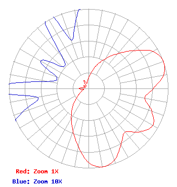 | ||||||||||||||||||
| Azimuth | Ratio | Azimuth | Ratio | Azimuth | Ratio | Azimuth | Ratio | ||||||||||||
| 0 | 0.131 | 10 | 0.202 | 20 | 0.316 | 30 | 0.432 | ||||||||||||
| 40 | 0.570 | 50 | 0.738 | 60 | 0.931 | 70 | 1.000 | ||||||||||||
| 80 | 0.955 | 90 | 0.813 | 100 | 0.717 | 110 | 0.846 | ||||||||||||
| 120 | 0.931 | 130 | 0.846 | 140 | 0.717 | 150 | 0.813 | ||||||||||||
| 160 | 0.955 | 170 | 1.000 | 180 | 0.931 | 190 | 0.738 | ||||||||||||
| 200 | 0.570 | 210 | 0.432 | 220 | 0.316 | 230 | 0.202 | ||||||||||||
| 240 | 0.131 | 250 | 0.089 | 260 | 0.065 | 270 | 0.116 | ||||||||||||
| 280 | 0.051 | 290 | 0.043 | 300 | 0.069 | 310 | 0.043 | ||||||||||||
| 320 | 0.051 | 330 | 0.116 | 340 | 0.065 | 350 | 0.089 | ||||||||||||
Structure Registration Number 1273462 Structure Type: TOWER Registered To: Piute County Structure Address: Approx. 2 Miles Sw Of Junction, Utah. Junction, UT County Name: Piute County ASR Issued: 03/10/2010 Date Built: 11/10/2008 Site Elevation: 1980 m (6496 ft.) Structure Height: 10.3 m (34 ft.) Height Overall: 10.3 m (34 ft.) Overall Height AMSL: 1990.3 m (6530 ft.) FAA Determination: 02/23/2010 FAA Study #: 2010-ANM-152-OE Paint & Light FAA Chapters: NONE Removed expiration date from determination. Scenario 1./jjs/case#635066 38-12-40.8 N 112-14-04.1 W (NAD 83) 38-12-40.9 N 112-14-01.4 W (Converted to NAD 27) |
550 North Main Junction, UT 84740 Applicant | Date: 08/23/2011 Application Certifier PIUTE COUNTY Courthouse Building Junction, UT 84740 Applicant MAURI KENT PARSONS 390 South 500 East P.o. Box 473 Monroe, UT 84754 FIELD ENGINEER MAURI PARSONS Piute County | |||||||||||||||||